Villars, Vaucluse
Villars | |
|---|---|
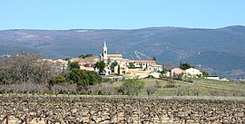 View of Villars with vineyards | |
 Coat of arms | |
show Location of Villars | |
 Villars | |
| Coordinates: 43°55′27″N 5°24′22″E / 43.9242°N 5.4061°ECoordinates: 43°55′27″N 5°24′22″E / 43.9242°N 5.4061°E | |
| Country | France |
| Region | Provence-Alpes-Côte d'Azur |
| Department | Vaucluse |
| Arrondissement | Apt |
| Canton | Apt |
| Government | |
| • Mayor (2020–2026) | Sylvie Pereira[1] |
| Area 1 | 30.05 km2 (11.60 sq mi) |
| Population (Jan. 2018)[2] | 778 |
| • Density | 26/km2 (67/sq mi) |
| Time zone | UTC+01:00 (CET) |
| • Summer (DST) | UTC+02:00 (CEST) |
| INSEE/Postal code | 84145 /84400 |
| Elevation | 247–1,184 m (810–3,885 ft) (avg. 300 m or 980 ft) |
| 1 French Land Register data, which excludes lakes, ponds, glaciers > 1 km2 (0.386 sq mi or 247 acres) and river estuaries. | |


Villars (Occitan: Lo Vilar) is a commune in the Vaucluse department in the Provence-Alpes-Côte d'Azur region in southeastern France.
See also[]
- Communes of the Vaucluse department
- Luberon
References[]
- ^ "Répertoire national des élus: les maires". data.gouv.fr, Plateforme ouverte des données publiques françaises (in French). 2 December 2020. Retrieved 7 December 2020.
- ^ "Populations légales 2018". INSEE. 28 December 2020.
| Wikimedia Commons has media related to Villars, Vaucluse. |
This Vaucluse geographical article is a stub. You can help Wikipedia by . |
Categories:
- Communes of Vaucluse
- Vaucluse geography stubs