Eyguières
show This article may be expanded with text translated from the corresponding article in French. (December 2008) Click [show] for important translation instructions. |
Eyguières | |
|---|---|
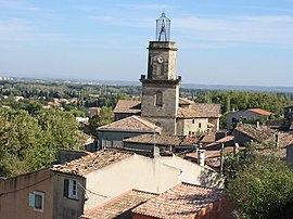 A general view of the village of Eyguières | |
 Coat of arms | |
show Location of Eyguières | |
 Eyguières | |
| Coordinates: 43°41′43″N 5°01′52″E / 43.6953°N 5.0311°ECoordinates: 43°41′43″N 5°01′52″E / 43.6953°N 5.0311°E | |
| Country | France |
| Region | Provence-Alpes-Côte d'Azur |
| Department | Bouches-du-Rhône |
| Arrondissement | Aix-en-Provence |
| Canton | Salon-de-Provence-1 |
| Intercommunality | Aix-Marseille-Provence |
| Government | |
| • Mayor (2020–2026) | Henri Pons[1] (UDI) |
| Area 1 | 68.75 km2 (26.54 sq mi) |
| Population (Jan. 2018)[2] | 6,926 |
| • Density | 100/km2 (260/sq mi) |
| Time zone | UTC+01:00 (CET) |
| • Summer (DST) | UTC+02:00 (CEST) |
| INSEE/Postal code | 13035 /13430 |
| Elevation | 63–496 m (207–1,627 ft) |
| 1 French Land Register data, which excludes lakes, ponds, glaciers > 1 km2 (0.386 sq mi or 247 acres) and river estuaries. | |


Eyguières (French pronunciation: [ɛɡjɛʁ]; Occitan: Aiguiera) is a commune in the Bouches-du-Rhône department in southern France.
Population[]
|
|
See also[]
References[]
- ^ "Répertoire national des élus: les maires". data.gouv.fr, Plateforme ouverte des données publiques françaises (in French). 2 December 2020. Retrieved 7 December 2020.
- ^ "Populations légales 2018". INSEE. 28 December 2020.
External links[]
- Tourism office website (in French and English)
| Wikimedia Commons has media related to Eyguières. |
| show Authority control |
|---|
This Bouches-du-Rhône geographical article is a stub. You can help Wikipedia by . |
Categories:
- Communes of Bouches-du-Rhône
- Bouches-du-Rhône geography stubs