Saint-Pierre-de-Mézoargues
This article may be expanded with text translated from the corresponding article in French. (December 2008) Click [show] for important translation instructions.
|
Saint-Pierre-de-Mézoargues | |
|---|---|
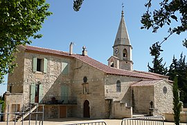 The church in Saint-Pierre-de-Mézoargues | |
 Coat of arms | |
Location of Saint-Pierre-de-Mézoargues  | |
 Saint-Pierre-de-Mézoargues | |
| Coordinates: 43°51′35″N 4°38′59″E / 43.8597°N 4.6497°ECoordinates: 43°51′35″N 4°38′59″E / 43.8597°N 4.6497°E | |
| Country | France |
| Region | Provence-Alpes-Côte d'Azur |
| Department | Bouches-du-Rhône |
| Arrondissement | Arles |
| Canton | Châteaurenard |
| Intercommunality | CA Arles-Crau-Camargue-Montagnette |
| Government | |
| • Mayor (2020–2026) | Laurie Pons |
| Area 1 | 4.13 km2 (1.59 sq mi) |
| Population (Jan. 2018)[1] | 210 |
| • Density | 51/km2 (130/sq mi) |
| Time zone | UTC+01:00 (CET) |
| • Summer (DST) | UTC+02:00 (CEST) |
| INSEE/Postal code | 13061 /13150 |
| Elevation | 9–18 m (30–59 ft) (avg. 12 m or 39 ft) |
| 1 French Land Register data, which excludes lakes, ponds, glaciers > 1 km2 (0.386 sq mi or 247 acres) and river estuaries. | |


Saint-Pierre-de-Mézoargues (French pronunciation: [sɛ̃ pjɛʁ də mezoaʁg]; Occitan: Sant Pèire de Mesoarga) is a commune in the Bouches-du-Rhône department in southern France.
Population[]
| Year | Pop. | ±% |
|---|---|---|
| 1793 | 198 | — |
| 1800 | 198 | +0.0% |
| 1806 | 190 | −4.0% |
| 1821 | 187 | −1.6% |
| 1831 | 200 | +7.0% |
| 1836 | 210 | +5.0% |
| 1841 | 210 | +0.0% |
| 1846 | 195 | −7.1% |
| 1851 | 226 | +15.9% |
| 1856 | 226 | +0.0% |
| 1861 | 242 | +7.1% |
| 1866 | 229 | −5.4% |
| 1872 | 223 | −2.6% |
| 1876 | 219 | −1.8% |
| 1881 | 119 | −45.7% |
| 1886 | 224 | +88.2% |
| 1891 | 196 | −12.5% |
| 1896 | 205 | +4.6% |
| 1901 | 213 | +3.9% |
| 1906 | 210 | −1.4% |
| 1911 | 204 | −2.9% |
| 1921 | 190 | −6.9% |
| 1926 | 215 | +13.2% |
| 1931 | 258 | +20.0% |
| 1936 | 198 | −23.3% |
| 1946 | 193 | −2.5% |
| 1954 | 204 | +5.7% |
| 1962 | 218 | +6.9% |
| 1968 | 204 | −6.4% |
| 1975 | 182 | −10.8% |
| 1982 | 215 | +18.1% |
| 1990 | 217 | +0.9% |
| 1999 | 225 | +3.7% |
| 2008 | 256 | +13.8% |
See also[]
References[]
- ^ "Populations légales 2018". The National Institute of Statistics and Economic Studies. 28 December 2020.
| Wikimedia Commons has media related to Saint-Pierre-de-Mezoargues. |
This Bouches-du-Rhône geographical article is a stub. You can help Wikipedia by . |
Categories:
- Communes of Bouches-du-Rhône
- Bouches-du-Rhône geography stubs