Rognac
show This article may be expanded with text translated from the corresponding article in French. (December 2008) Click [show] for important translation instructions. |
Rognac | |
|---|---|
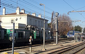 Rognac railway station, with a passing freight train and an Intercity-TER | |
 Coat of arms | |
show Location of Rognac | |
 Rognac | |
| Coordinates: 43°29′19″N 5°13′59″E / 43.4886°N 5.2331°ECoordinates: 43°29′19″N 5°13′59″E / 43.4886°N 5.2331°E | |
| Country | France |
| Region | Provence-Alpes-Côte d'Azur |
| Department | Bouches-du-Rhône |
| Arrondissement | Istres |
| Canton | Berre-l'Étang |
| Intercommunality | Aix-Marseille-Provence |
| Government | |
| • Mayor (2020–2026) | Sylvie Miceli-Houdais |
| Area 1 | 17.46 km2 (6.74 sq mi) |
| Population (Jan. 2018)[1] | 12,080 |
| • Density | 690/km2 (1,800/sq mi) |
| Time zone | UTC+01:00 (CET) |
| • Summer (DST) | UTC+02:00 (CEST) |
| INSEE/Postal code | 13081 /13340 |
| Elevation | 0–271 m (0–889 ft) (avg. 15 m or 49 ft) |
| 1 French Land Register data, which excludes lakes, ponds, glaciers > 1 km2 (0.386 sq mi or 247 acres) and river estuaries. | |


Rognac (French pronunciation: [ʁɔɲak]; Occitan: Ronhac) is a commune in the Bouches-du-Rhône department in southern France.
International relations[]
Rognac is twinned with:
- Rockenhausen, Germany
 Veria, Greece
Population[]
|
|
See also[]
References[]
- ^ "Populations légales 2018". INSEE. 28 December 2020.
| Wikimedia Commons has media related to Rognac. |
| show Authority control |
|---|
This Bouches-du-Rhône geographical article is a stub. You can help Wikipedia by . |
Categories:
- Communes of Bouches-du-Rhône
- Bouches-du-Rhône geography stubs