Peyrolles-en-Provence
show This article may be expanded with text translated from the corresponding article in French. (December 2008) Click [show] for important translation instructions. |
Peyrolles-en-Provence | |
|---|---|
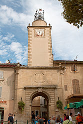 The 17th century bell tower in Peyrolles-en-Provence | |
 Coat of arms | |
show Location of Peyrolles-en-Provence | |
 Peyrolles-en-Provence | |
| Coordinates: 43°38′47″N 5°35′09″E / 43.6464°N 5.5858°ECoordinates: 43°38′47″N 5°35′09″E / 43.6464°N 5.5858°E | |
| Country | France |
| Region | Provence-Alpes-Côte d'Azur |
| Department | Bouches-du-Rhône |
| Arrondissement | Aix-en-Provence |
| Canton | Trets |
| Intercommunality | Aix-Marseille-Provence |
| Government | |
| • Mayor (2020–2026) | Olivier Frégeac |
| Area 1 | 34.9 km2 (13.5 sq mi) |
| Population (Jan. 2018)[1] | 5,125 |
| • Density | 150/km2 (380/sq mi) |
| Time zone | UTC+01:00 (CET) |
| • Summer (DST) | UTC+02:00 (CEST) |
| INSEE/Postal code | 13074 /13860 |
| Elevation | 201–782 m (659–2,566 ft) (avg. 220 m or 720 ft) |
| 1 French Land Register data, which excludes lakes, ponds, glaciers > 1 km2 (0.386 sq mi or 247 acres) and river estuaries. | |


Peyrolles-en-Provence (French pronunciation: [pɛʁɔl ɑ̃ pʁɔvɑ̃s]; Occitan: Peiròla de Provença) is a commune in the Bouches-du-Rhône department in southern France.
Population[]
| Year | Pop. | ±% |
|---|---|---|
| 1793 | 769 | — |
| 1800 | 775 | +0.8% |
| 1806 | 913 | +17.8% |
| 1821 | 1,135 | +24.3% |
| 1831 | 1,171 | +3.2% |
| 1836 | 1,170 | −0.1% |
| 1841 | 1,203 | +2.8% |
| 1846 | 1,159 | −3.7% |
| 1851 | 1,222 | +5.4% |
| 1856 | 1,216 | −0.5% |
| 1861 | 1,260 | +3.6% |
| 1866 | 1,260 | +0.0% |
| 1872 | 1,255 | −0.4% |
| 1876 | 1,194 | −4.9% |
| 1881 | 1,040 | −12.9% |
| 1886 | 1,022 | −1.7% |
| 1891 | 974 | −4.7% |
| 1896 | 1,005 | +3.2% |
| 1901 | 927 | −7.8% |
| 1906 | 886 | −4.4% |
| 1911 | 921 | +4.0% |
| 1921 | 804 | −12.7% |
| 1926 | 811 | +0.9% |
| 1931 | 860 | +6.0% |
| 1936 | 906 | +5.3% |
| 1946 | 1,049 | +15.8% |
| 1954 | 1,199 | +14.3% |
| 1962 | 2,003 | +67.1% |
| 1968 | 2,249 | +12.3% |
| 1975 | 2,297 | +2.1% |
| 1982 | 2,560 | +11.4% |
| 1990 | 2,918 | +14.0% |
| 1999 | 3,914 | +34.1% |
| 2008 | 4,477 | +14.4% |
See also[]
References[]
- ^ "Populations légales 2018". INSEE. 28 December 2020.
External links[]
- Official website (in French)
| Wikimedia Commons has media related to Peyrolles-en-Provence. |
| show Authority control |
|---|
This Bouches-du-Rhône geographical article is a stub. You can help Wikipedia by . |
Categories:
- Communes of Bouches-du-Rhône
- Bouches-du-Rhône geography stubs