Carnoux-en-Provence
Carnoux-en-Provence
Carnós de Provença (Occitan) | |
|---|---|
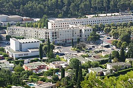 A view of Carnoux-en-Provence | |
 Coat of arms | |
show Location of Carnoux-en-Provence | |
 Carnoux-en-Provence | |
| Coordinates: 43°15′23″N 5°33′52″E / 43.2564°N 5.5644°ECoordinates: 43°15′23″N 5°33′52″E / 43.2564°N 5.5644°E | |
| Country | France |
| Region | Provence-Alpes-Côte d'Azur |
| Department | Bouches-du-Rhône |
| Arrondissement | Marseille |
| Canton | La Ciotat |
| Intercommunality | Aix-Marseille-Provence |
| Government | |
| • Mayor (2020–2026) | Jean-Pierre Giorgi |
| Area 1 | 3.45 km2 (1.33 sq mi) |
| Population (Jan. 2018)[1] | 6,564 |
| • Density | 1,900/km2 (4,900/sq mi) |
| Time zone | UTC+01:00 (CET) |
| • Summer (DST) | UTC+02:00 (CEST) |
| INSEE/Postal code | 13119 /13470 |
| Dialling codes | 0491 |
| Elevation | 180–380 m (590–1,250 ft) |
| 1 French Land Register data, which excludes lakes, ponds, glaciers > 1 km2 (0.386 sq mi or 247 acres) and river estuaries. | |


Carnoux-en-Provence (French pronunciation: [kaʁnu ɑ̃ pʁɔvɑ̃s]; Occitan: Carnós de Provença), commonly referred to as Carnoux, is a commune located 16.4 km (10.2 mi) from the northeast of Marseille in the Bouches-du-Rhône department in the Provence-Alpes-Côte d'Azur region in Southern France. It was created in 1966 from the commune of Roquefort-la-Bédoule. In 2018, it had a population of 6,564.
Camp de Carpiagne, the garrison for the 1st-11th Cuirassier Regiment armoured (tank) regiment of the French Army is found here.
History[]
In 1957, French citizens repatriated from Morocco established the town of Carnoux on the land of Roquefort-la-Bédoule, where those repatriated from Algeria were also welcomed from 1962.[2]
In 1966, the commune of Carnoux-en-Provence was officially created, becoming the 119th commune in Bouches-du-Rhône.[3] The city's urban and municipal policies were developed by French architect Jean Rozan (1887–1977).
Population[]
Population development since 1968:
| Year | Pop. | ±% |
|---|---|---|
| 1968 | 2,207 | — |
| 1975 | 3,120 | +41.4% |
| 1982 | 5,149 | +65.0% |
| 1990 | 6,363 | +23.6% |
| 1999 | 7,042 | +10.7% |
| 2008 | 6,999 | −0.6% |
| 2016 | 6,546 | −6.5% |
Geography[]
Situation[]
Carnoux-en-Provence is situated to the east of Marseille, with Aubagne to the north and Cassis to the south, with hills to the east extending to the Massif de Saint-Cyr.
Climat[]
Carnoux-en-Provence benefits from a Mediterranean weather.
Adjacent towns[]
- Aubagne to the north and west;
- Cassis to the south;
- Roquefort-la-Bédoule to the southeast and east.
List of mayors[]
| Term start | Term end | Name | Affiliation |
|---|---|---|---|
| January 1967 | March 1971 | Pierre Maret | |
| March 1971 | December 1977 (resignation) |
Adolphe Faure | |
| January 1978 | March 1983 | Marc Laprie | |
| March 1983 | March 2001 | Jean Chaland[5] | DVD |
| March 2001 | In office | Jean-Pierre Giorgi | DVD |
See also[]
References[]
- ^ "Populations légales 2018". INSEE. 28 December 2020.
- ^ "Histoire de Carnoux". Archived from the original on 2011-11-23. Retrieved 2019-12-15.
- ^ Site sur la Population et les Limites Administratives de la France
- ^ Discours de Jean Chaland à l'occasion des 30 ans de Carnoux-en-Provence
- ^ "Jean Chaland nous a quittés". La Provence. 2014-02-14.
| Wikimedia Commons has media related to Carnoux-en-Provence. |
| show Authority control |
|---|
- Communes of Bouches-du-Rhône