Fergana Oblast
| Fergana Oblast Ферганская область Fargʻona viloyati | |||||||||
|---|---|---|---|---|---|---|---|---|---|
| Oblast of Russia | |||||||||
| 1876–1917 | |||||||||
 Coat of arms
| |||||||||
 | |||||||||
| Capital | Kokand | ||||||||
| History | |||||||||
| History | |||||||||
• Established | 1876 | ||||||||
| 1917 | |||||||||
| |||||||||
| Today part of | Uzbekistan Tajikistan Kyrgyzstan | ||||||||
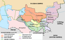
The Fergana Oblast (Russian: Ферганская область; Uzbek: Fargʻona viloyati) was an oblast (province) of the Russian Empire. It roughly corresponded to most of present-day Fergana Valley. It was created in 1876 when the territories of the former Khanate of Kokand were annexed to Russia (except for the oblasts of Syr-Darya Oblast and Semirechye Oblast, which were part of the khanate before Russian conquest between 1853 and 1865). Its administrative center was the city of Kokand.
The Oblast was disbanded after the Russian Revolution and on April 30, 1918 the region became a part of the Turkestan ASSR.
Administrative division[]
As of 1897, the Fergana Oblast was divided into 5 uyezds:
| Uyezd | Uyezd city (pop.) | Area, sq versta |
Population[1] |
|---|---|---|---|
| Margelan | Novy Margelan (8,928) | 14069.1 | 321,860 |
| Andizhan | Andizhan (47,627) | 13333.2 | 360,267 |
| Kokand | Kokand (81,354) | 13212.6 | 364,658 |
| Namangan | Namangan (62,017) | 15273.4 | 363,789 |
| Osh | Osh (34,157) | 65252.7 | 161,640 |
Demographics[]
As of 1897, 1,572,214 people populated the oblast. Turkic speaking Sarts (Today called Uzbeks) constituted the majority of the population. Significant minorities consisted of Kyrgyz and Tajiks. Total Turkic speaking were 1.439,989 (91,6% of the total population of the oblast).
Ethnic groups in 1897[2][]
| TOTAL | 1,572,214 | 100% |
|---|---|---|
| Sarts | 788,989 | 50,2% |
| Unspecified Turkic dialects | 261,234 | 16,6% |
| Kyrgyz | 201,579 | 12,8% |
| Uzbeks | 153,780 | 9,8% |
| Tajiks | 114,081 | 7,3% |
| Uyghurs | 14,915 | 0,9% |
| Karakalpaks | 11,056 | 0,7% |
| Russians | 8,140 | 0,5% |
| Kipchak | 7,584 | 0,5% |
| Jews | 1,378 | ... |
References[]
- ^ demoscope.ru 1897 census results.
- ^ "Демоскоп Weekly - Приложение. Справочник статистических показателей".

- States and territories established in 1876
- States and territories disestablished in 1917
- Fergana Oblast
- Oblasts of the Russian Empire
- Central Asia in the Russian Empire