Mogilev Governorate
Mogilev Governorate | |
|---|---|
 Coat of arms | |
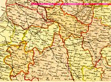 Belarusian Governorates in 1882 maps | |
| Country | Russia |
| Political status | Governorate |
| Region | European Russia |
| Established | 1772 |
| Abolished | 1919 |
| Area | |
| • Total | 47,951 km2 (18,514 sq mi) |
| Population (1897) | |
| • Total | 1,686,764 |
| • Density | 35/km2 (91/sq mi) |
The Mogilev Governorate (Mogilevskaya Gubernya) or Government of Mogilev was a governorate (guberniya) of the Russian Empire in the territory of the present day Belarus. Its capital was in Mogilev, referred to as Mogilev-on-the-Dnieper, or Mogilev Gubernskiy.[1]
The area of the governorate was inhabited in the 10th century by the Slav tribes of the Krivichi and Radimichi. In the 14th century, the land became part of Lithuania, and later Poland.[1] The governorate was formed in 1772, in the aftermath of the First partition of Poland, from parts of the voivodeships of Witebsk, Mścisław, Połock and Inflanty. Parts of these territories were also used to form the Pskov Governorate. In 1796, Mogilev and Governorates were united and formed . In 1802, Belorussian Governorate was divided into Vitebsk Governorate and Mogilev Governorate. In 1917, Vitebsk, Mogilev and parts of Minsk Governorate and Vilna Governorate were united into the (from 1918 known as ). In 1918, it was joined by Smolensk Governorate and in October 1919, Mogilev Governorate was reformed into Gomel Governorate.[2]
Subdivisions[]
- Bykhovsky Uyezd
- Gomelsky Uyezd
- Goretsky Uyezd
- Klimovichskiy Uyezd
- Mogilyovsky Uyezd
- Mstislavsky Uyezd
- Orshansky Uyezd
- Rogachyovsky Uyezd
- Sennensky Uyezd
- Chaussky Uyezd
- Cherikovsky Uyezd
References[]
- ^ a b Chisholm, Hugh, ed. (1911). . Encyclopædia Britannica (11th ed.). Cambridge University Press.
- ^ http://www.jewishgen.org/Belarus/grodno/distcent.htm
External links[]
Coordinates: 53°55′00″N 30°21′00″E / 53.9167°N 30.3500°E

This Belarus location article is a stub. You can help Wikipedia by . |
This Russian history–related article is a stub. You can help Wikipedia by . |
- Mogilev Governorate
- Governorates of the Russian Empire
- States and territories established in 1772
- States and territories disestablished in 1919
- History of Mogilev
- Former subdivisions of Belarus
- 1772 establishments in the Russian Empire
- 1919 disestablishments in Russia
- Belarus geography stubs
- Russian history stubs