Flastroff
Flastroff | |
|---|---|
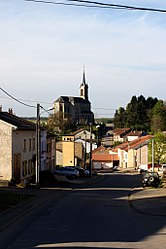 The Rue Saint-Éloi in Flastroff | |
 Coat of arms | |
show Location of Flastroff | |
 Flastroff | |
| Coordinates: 49°22′03″N 6°32′01″E / 49.3675°N 6.5336°ECoordinates: 49°22′03″N 6°32′01″E / 49.3675°N 6.5336°E | |
| Country | France |
| Region | Grand Est |
| Department | Moselle |
| Arrondissement | Thionville |
| Canton | Bouzonville |
| Intercommunality | Bouzonvillois-Trois Frontières |
| Government | |
| • Mayor (2020–2026) | Roland Schneider[1] |
| Area 1 | 8.38 km2 (3.24 sq mi) |
| Population (Jan. 2018)[2] | 324 |
| • Density | 39/km2 (100/sq mi) |
| Time zone | UTC+01:00 (CET) |
| • Summer (DST) | UTC+02:00 (CEST) |
| INSEE/Postal code | 57215 /57320 |
| Elevation | 214–307 m (702–1,007 ft) (avg. 220 m or 720 ft) |
| 1 French Land Register data, which excludes lakes, ponds, glaciers > 1 km2 (0.386 sq mi or 247 acres) and river estuaries. | |


Flastroff (German: Flasdorf; Lorraine Franconian: Flooschtroff) is a commune in the Moselle department in Grand Est in north-eastern France.
Localities of the commune: Zeurange (German: Zeringen).
See also[]
| Wikimedia Commons has media related to Flastroff. |
References[]
- ^ "Répertoire national des élus: les maires". data.gouv.fr, Plateforme ouverte des données publiques françaises (in French). 2 December 2020.
- ^ "Populations légales 2018". INSEE. 28 December 2020.
Categories:
- Communes of Moselle (department)
- Thionville arrondissement geography stubs