Hillsborough, New Brunswick
Hillsborough | |
|---|---|
Village | |
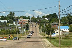 Main Street (Route 114) looking north | |
 Seal | |
 Hillsborough Location of Hillsborough, New Brunswick | |
| Coordinates: 45°55′22″N 64°38′43″W / 45.92277°N 64.64523°W | |
| Country | Canada |
| Province | New Brunswick |
| County | Albert County |
| Parish | Hillsborough Parish |
| Founded | 1700s |
| Incorporated Village | 1966 |
| Area | |
| • Land | 12.98 km2 (5.01 sq mi) |
| Population (2016) | |
| • Total | 1,277 |
| • Density | 104.0/km2 (269/sq mi) |
| Time zone | UTC-4 (Atlantic (AST)) |
| • Summer (DST) | UTC-3 () |
| Canadian Postal code | E |
| Area code(s) | 506 |
| Telephone Exchange | 203 734 |
| Highway | |
| Website | villageofhillsborough.ca |

Hillsborough is a village in Albert County in the Canadian province of New Brunswick. The village is situated on a hill overlooking the Petitcodiac River near the intersection of Route 910 and Route 114. Hillsborough is the largest settlement in Hillsborough Parish.
History[]
Originally established around 1700 as "Blanchard's Village" by Acadian farmers, they lived here for sixty years, building dykes that are still in use. Before the Great Expulsion of the Acadians in 1755, the area was almost 100% French. Now, few Acadians live there, though there are several Acadian settlements on the opposite bank of the Petitcodiac River, such as Pre d'en Haut, New Brunswick.
On September 4, 1755, the Battle of Petitcodiac was fought near Hillsborough. After the capture of Fort Beausejour during the Seven Years' War, in an attempt to gain control over the region, the British sent a punitive expedition consisting of two companies of British colonial troops into the Petitcodiac River Valley to destroy the Acadian settlements located there. While the main body finished their operation on the eastern bank, a detachment was dispatched to the western bank. When the detachment under Major Joseph Frye approached Blanchard's Village, located near where Hillsborough now stands, it encountered French forces under the command of Captain Charles Deschamps de Boishébert and was driven off with heavy losses. The site is marked by a National Historic Sites and Monument plaque.
In 1766, a group of settlers arrived in the area led by Matthias Somers, Michael Lutz, Jacob Trietz (Trites), Charles Jones, and Heinrich Stieff (Steeves).[1] Heinrich Steeves had seven sons and the name Steeves is still common among residents.
Demographics[]
| Year | Pop. | ±% |
|---|---|---|
| 1981 | 1,239 | — |
| 1986 | 1,214 | −2.0% |
| 1996 | 1,272 | +4.8% |
| 2001 | 1,288 | +1.3% |
| 2006 | 1,292 | +0.3% |
| 2011 | 1,350 | +4.5% |
Places of note[]

- Hillsborough is home to the Albert County Chamber of Commerce and the historic New Brunswick Railway Museum[2] and the Hon. William Henry Steeves House Museum.
- Grays Island is a cemetery.
- Surrey was amalgamated into Hillsborough.
Education[]
Notable people[]
- William Steeves, one of the Fathers of Confederation
- Hugh McMonagle
- William James Lewis
- Neil McNeil, former Catholic archbishop of Toronto, was a native of Hillsborough.
- Burpee L. Steeves Lieutenant Governor of Idaho
See also[]
References[]
External links[]
| Wikimedia Commons has media related to Hillsborough, New Brunswick. |
Places adjacent to Hillsborough, New Brunswick | ||||||||||||||||
|---|---|---|---|---|---|---|---|---|---|---|---|---|---|---|---|---|
| ||||||||||||||||
Subdivisions of New Brunswick | |
|---|---|
| Subdivisions |
|
| Cities | |
| Villages |
|
| |
- Communities in Albert County, New Brunswick
- Villages in New Brunswick
- Communities in Greater Moncton
- Mining communities in New Brunswick