Hyannis, Nebraska
Hyannis, Nebraska | |
|---|---|
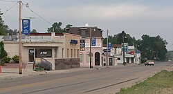 Downtown Hyannis, looking southwest. Nebraska Highway 2/61 is in the foreground | |
 Location of Hyannis, Nebraska | |
| Coordinates: 42°0′3″N 101°45′55″W / 42.00083°N 101.76528°WCoordinates: 42°0′3″N 101°45′55″W / 42.00083°N 101.76528°W | |
| Country | United States |
| State | Nebraska |
| County | Grant |
| Area | |
| • Total | 0.52 sq mi (1.35 km2) |
| • Land | 0.52 sq mi (1.35 km2) |
| • Water | 0.00 sq mi (0.00 km2) |
| Elevation | 3,757 ft (1,145 m) |
| Population | |
| • Total | 182 |
| • Estimate (2019)[3] | 184 |
| • Density | 353.17/sq mi (136.39/km2) |
| Time zone | UTC-7 (Mountain (MST)) |
| • Summer (DST) | UTC-6 (MDT) |
| ZIP code | 69350 |
| Area code(s) | 308 |
| FIPS code | 31-23655[4] |
| GNIS feature ID | 0830221[5] |

Hyannis is a village in Grant County, Nebraska, United States. The population was 182 at the 2010 census. It is the county seat of Grant County.[6] It is centrally located in the extensive, unique and remote region of grasslands known as the Sandhills of Nebraska at the intersection of two Nebraska State Highways: NSH 61 which runs north and south, and NSH 2, which runs east and west.
History[]
Hyannis was laid out in 1888 when the Chicago, Burlington and Quincy Railroad was extended to that point.[7] It was named after the town of Hyannis, Massachusetts by a railroad official.[8][9]
Geography[]
Hyannis is located at 42°0′3″N 101°45′55″W / 42.00083°N 101.76528°W (42.000817, -101.765202),[10] in the Nebraska Sandhills. According to the United States Census Bureau, the village has a total area of 0.52 square miles (1.35 km2), all land.[11]
Demographics[]
| Historical population | |||
|---|---|---|---|
| Census | Pop. | %± | |
| 1910 | 262 | — | |
| 1920 | 384 | 46.6% | |
| 1930 | 384 | 0.0% | |
| 1940 | 449 | 16.9% | |
| 1950 | 432 | −3.8% | |
| 1960 | 373 | −13.7% | |
| 1970 | 345 | −7.5% | |
| 1980 | 336 | −2.6% | |
| 1990 | 210 | −37.5% | |
| 2000 | 287 | 36.7% | |
| 2010 | 182 | −36.6% | |
| 2019 (est.) | 184 | [3] | 1.1% |
| U.S. Decennial Census[12] | |||
2010 census[]
As of the census[2] of 2010, there were 182 people, 98 households, and 61 families residing in the village. The population density was 350.0 inhabitants per square mile (135.1/km2). There were 132 housing units at an average density of 253.8 per square mile (98.0/km2). The racial makeup of the village was 97.8% White and 2.2% from two or more races. Hispanic or Latino of any race were 1.6% of the population.
There were 98 households, of which 12.2% had children under the age of 18 living with them, 56.1% were married couples living together, 4.1% had a female householder with no husband present, 2.0% had a male householder with no wife present, and 37.8% were non-families. 33.7% of all households were made up of individuals, and 15.3% had someone living alone who was 65 years of age or older. The average household size was 1.86 and the average family size was 2.30.
The median age in the village was 54.2 years. 12.1% of residents were under the age of 18; 4.9% were between the ages of 18 and 24; 14.2% were from 25 to 44; 38.3% were from 45 to 64; and 30.2% were 65 years of age or older. The gender makeup of the village was 50.0% male and 50.0% female.
2000 census[]
As of the census[4] of 2000, there were 287 people, 116 households, and 88 families residing in the village. The population density was 422.8 people per square mile (163.0/km2). There were 165 housing units at an average density of 243.1 per square mile (93.7/km2). The racial makeup of the village was 98.61% White, 1.39% from other races. Hispanic or Latino of any race were 2.79% of the population.
There were 116 households, out of which 36.2% had children under the age of 18 living with them, 64.7% were married couples living together, 9.5% had a female householder with no husband present, and 23.3% were non-families. 23.3% of all households were made up of individuals, and 9.5% had someone living alone who was 65 years of age or older. The average household size was 2.47 and the average family size was 2.91.
In the village, the population was spread out, with 28.2% under the age of 18, 5.6% from 18 to 24, 24.7% from 25 to 44, 26.5% from 45 to 64, and 15.0% who were 65 years of age or older. The median age was 41 years. For every 100 females, there were 111.0 males. For every 100 females age 18 and over, there were 102.0 males.
As of 2000 the median income for a household in the village was $29,688, and the median income for a family was $35,313. Males had a median income of $26,000 versus $13,906 for females. The per capita income for the village was $13,906. About 4.7% of families and 6.0% of the population were below the poverty line, including 9.1% of those under the age of eighteen and none of those 65 or over.
Notable people[]
- Al Davis, former member of the Nebraska Legislature
- Skeeter Thurston, retired rodeo competitor
References[]
- ^ "2019 U.S. Gazetteer Files". United States Census Bureau. Retrieved July 26, 2020.
- ^ a b "U.S. Census website". United States Census Bureau. Retrieved 2012-06-24.
- ^ a b "Population and Housing Unit Estimates". United States Census Bureau. May 24, 2020. Retrieved May 27, 2020.
- ^ a b "U.S. Census website". United States Census Bureau. Retrieved 2008-01-31.
- ^ "US Board on Geographic Names". United States Geological Survey. 2007-10-25. Retrieved 2008-01-31.
- ^ "Find a County". National Association of Counties. Archived from the original on May 31, 2011. Retrieved 2011-06-07.
- ^ Burr, George L. (1921). History of Hamilton and Clay Counties, Nebraska, Volume 1. S.J. Clarke Publishing Company. p. 114.
- ^ Alan Boye (1 April 2007). The Complete Roadside Guide to Nebraska. U of Nebraska Press. p. 386. ISBN 978-0-8032-3378-2.
- ^ Fitzpatrick, Lillian L. (1960). Nebraska Place-Names. University of Nebraska Press. p. 68. ISBN 0-8032-5060-6. A 1925 edition is available for download at University of Nebraska—Lincoln Digital Commons.
- ^ "US Gazetteer files: 2010, 2000, and 1990". United States Census Bureau. 2011-02-12. Retrieved 2011-04-23.
- ^ "US Gazetteer files 2010". United States Census Bureau. Archived from the original on January 12, 2012. Retrieved 2012-06-24.
- ^ "Census of Population and Housing". Census.gov. Retrieved June 4, 2015.
Municipalities and communities of Grant County, Nebraska, United States | ||
|---|---|---|
| Village | ||
| Unincorporated communities | ||
| ||
- Villages in Grant County, Nebraska
- Villages in Nebraska
- County seats in Nebraska