La Souterraine
La Souterraine | |
|---|---|
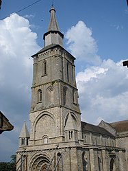 The bell tower of the church in La Souterraine | |
 Coat of arms | |
show Location of La Souterraine | |
 La Souterraine | |
| Coordinates: 46°14′15″N 1°29′10″E / 46.2374°N 1.4862°ECoordinates: 46°14′15″N 1°29′10″E / 46.2374°N 1.4862°E | |
| Country | France |
| Region | Nouvelle-Aquitaine |
| Department | Creuse |
| Arrondissement | Guéret |
| Canton | La Souterraine |
| Intercommunality | CC Pays Sostranien |
| Government | |
| • Mayor (2008–2014) | Jean-François Muguay |
| Area 1 | 37.07 km2 (14.31 sq mi) |
| Population (Jan. 2018)[1] | 5,094 |
| • Density | 140/km2 (360/sq mi) |
| Time zone | UTC+01:00 (CET) |
| • Summer (DST) | UTC+02:00 (CEST) |
| INSEE/Postal code | 23176 /23300 |
| Elevation | 284–456 m (932–1,496 ft) |
| 1 French Land Register data, which excludes lakes, ponds, glaciers > 1 km2 (0.386 sq mi or 247 acres) and river estuaries. | |


La Souterraine (Limousin: La Sotarrana) is a commune in the Creuse department in the Nouvelle-Aquitaine region in central France.
Geography[]
La Souterraine is an area of farming and light industry, comprising the town and a few small hamlets. It is situated some 20 miles (32 km) west of Guéret, at the junction of the D1, D912, D951 and the N145 roads. It is also served by a TER railway link. The small river Sédelle, a tributary of the Creuse, flows through the town. The sources of the Benaize, a tributary of the Anglin, and the Brame, a tributary of the Gartempe, are both in the commune.
History[]
There is evidence of pre-Roman occupation here, attested by the discovery of Stone Age tools and a menhir. Remains of Roman villas and temples have been unearthed. In medieval times, a church and fortified walls were built. The name of the town, translating as ‘subterranean’, comes from the underground parts of the church, the crypt.
Population[]
| Year | Pop. | ±% |
|---|---|---|
| 1962 | 4,718 | — |
| 1968 | 5,104 | +8.2% |
| 1975 | 5,302 | +3.9% |
| 1982 | 5,690 | +7.3% |
| 1990 | 5,490 | −3.5% |
| 1999 | 5,320 | −3.1% |
| 2008 | 5,435 | +2.2% |
Sights[]
- The church dating from the eleventh century, with its Roman crypt.
- The fifteenth-century Manorhouse de Châteaurenaud.
- The thirteenth-century gate, the Porte de St.Jean, and the rest of the ramparts.
- A feudal motte, circular tower and the castle at Bridiers.
- The eighteenth-century chapel of the hospital.
- The ancient chapel of Sainte-Eutrope.
- The fourteenth-century church at Bussière-Madeleine.

See also[]
References[]
- ^ "Populations légales 2018". INSEE. 28 December 2020.
External links[]
- Official website of La Souterraine (in French)
| Wikimedia Commons has media related to La Souterraine. |
| show Authority control |
|---|
This Creuse geographical article is a stub. You can help Wikipedia by . |
- Communes of Creuse
- County of La Marche
- Creuse geography stubs