Les Montils
Les Montils | |
|---|---|
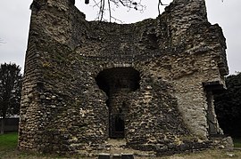 Ruins of a tower | |
 Coat of arms | |
show Location of Les Montils | |
 Les Montils | |
| Coordinates: 47°29′46″N 1°17′52″E / 47.4961°N 1.2978°ECoordinates: 47°29′46″N 1°17′52″E / 47.4961°N 1.2978°E | |
| Country | France |
| Region | Centre-Val de Loire |
| Department | Loir-et-Cher |
| Arrondissement | Blois |
| Canton | Blois-3 |
| Intercommunality | CA Blois Agglopolys |
| Government | |
| • Mayor (2020–2026) | Alain Duchalais |
| Area 1 | 9.27 km2 (3.58 sq mi) |
| Population (Jan. 2018)[1] | 1,919 |
| • Density | 210/km2 (540/sq mi) |
| Time zone | UTC+01:00 (CET) |
| • Summer (DST) | UTC+02:00 (CEST) |
| INSEE/Postal code | 41147 /41120 |
| Elevation | 62–101 m (203–331 ft) (avg. 92 m or 302 ft) |
| 1 French Land Register data, which excludes lakes, ponds, glaciers > 1 km2 (0.386 sq mi or 247 acres) and river estuaries. | |


Les Montils (French pronunciation: [le mɔ̃til]) is a commune in the Loir-et-Cher department of central France.
Geography[]
Les Montils is at the edge of the Sologne, at an altitude of 80 m (approx.). This town is bordered by the Cosson in the north, through the Beuvron. To the west of the village, the Bièvre flows into Beuvron. At this point, there are numerous beavers.
Tourism[]
- Recreation area Masnières
- A model railway with a train that can be ridden by visitors in the summer months.
Sights[]
- From the old village remains a strong tower, the tower of Montils, an arch and some walls.
- Château de Frileuse
Agriculture[]
- Wine : Cheverny, AOC
Population[]
| Year | Pop. | ±% |
|---|---|---|
| 1962 | 707 | — |
| 1968 | 717 | +1.4% |
| 1975 | 808 | +12.7% |
| 1982 | 1,046 | +29.5% |
| 1990 | 1,196 | +14.3% |
| 1999 | 1,436 | +20.1% |
| 2007 | 1,693 | +17.9% |
Personalities[]
- Antonio de La Gandara (1861–1917), painter
See also[]
- Communes of the Loir-et-Cher department
References[]
- ^ "Populations légales 2018". INSEE. 28 December 2020.
| Wikimedia Commons has media related to Les Montils. |
| show Communes of the Loir-et-Cher department |
|---|
| show Authority control |
|---|
This Loir-et-Cher geographical article is a stub. You can help Wikipedia by . |
Categories:
- Communes of Loir-et-Cher
- Loir-et-Cher geography stubs