Monee Township, Will County, Illinois
Monee Township | |
|---|---|
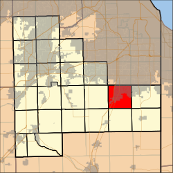 Location in Will County | |
 Will County's location in Illinois | |
| Coordinates: 41°25′28″N 87°43′25″W / 41.42444°N 87.72361°WCoordinates: 41°25′28″N 87°43′25″W / 41.42444°N 87.72361°W | |
| Country | United States |
| State | Illinois |
| County | Will |
| Established | November 6, 1849 |
| Government | |
| • Supervisor | Donna T. Dettbarn |
| Area | |
| • Total | 35.87 sq mi (92.9 km2) |
| • Land | 35.8 sq mi (92.72 km2) |
| • Water | 0.07 sq mi (0.18 km2) 0.20% |
| Elevation | 774 ft (236 m) |
| Population (2010) | |
| • Estimate (2016)[1] | 15,490 |
| • Density | 437.7/sq mi (169.0/km2) |
| Time zone | UTC-6 (CST) |
| • Summer (DST) | UTC-5 (CDT) |
| ZIP codes | 60417, 60449, 60466, 60484 |
| Area code(s) | 708 |
| FIPS code | 17-197-49958 |
| Website | www |


Monee Township is one of 24 townships in Will County, Illinois. As of the 2010 census, its population was 15,669 and it contained 6,182 housing units.[2] Monee Township used to be known as Carcy Township, but the name was changed at an unknown date.
Geography[]
According to the 2010 census, the township has a total area of 35.87 square miles (92.9 km2), of which 35.8 square miles (93 km2) (or 99.80%) is land and 0.07 square miles (0.18 km2) (or 0.20%) is water.[2] It includes all of Monee, almost all of University Park as well as a small portion of Park Forest.
Boundaries[]
Monee Township is bordered by Western Avenue on the east, Steger Road on the north (where Cook County and Will County share a border), Harlem Avenue (Illinois Route 43) on the west, and Offner Road on the south.
Cities, towns, villages[]
- Monee
- University Park (vast majority)
- Park Forest (small portion)
Adjacent townships[]
- Rich Township, Cook County (north)
- Bloom Township, Cook County (northeast)
- Crete Township (east)
- Washington Township (southeast)
- Will Township (south)
- Peotone Township (southwest)
- Green Garden Township (west)
- Frankfort Township (northwest)
Cemeteries[]
The township contains the Saint Paul's United Church of Christ Cemetery.
Major highways[]
 Illinois Route 50
 Interstate 80
Lakes[]
- Pine Lake
Landmarks[]
- Raccoon Grove Nature Preserve
Demographics[]
| Historical population | |||
|---|---|---|---|
| Census | Pop. | %± | |
| 2016 (est.) | 15,490 | [1] | |
| U.S. Decennial Census[3] | |||
Political districts[]
- Illinois' 2nd congressional district
- State House District 29
- State House District 80
- State Senate District 15
- State Senate District 40
References[]
- ^ a b "Population and Housing Unit Estimates". Retrieved June 9, 2017.
- ^ a b "Population, Housing Units, Area, and Density: 2010 - County -- County Subdivision and Place -- 2010 Census Summary File 1". United States Census. Archived from the original on 2020-02-12. Retrieved 2013-05-28.
- ^ "Census of Population and Housing". Census.gov. Retrieved June 4, 2016.
External links[]
- Monee Township official website
- City-data.com
- Illinois State Archives
- Township Officials of Illinois
- Will County official site
Municipalities and communities of Will County, Illinois, United States | ||
|---|---|---|
County seat: Joliet | ||
| Cities |
| |
| Villages |
| |
| Townships | ||
| CDPs | ||
| Other communities | ||
| Ghost town | ||
| Footnotes | ‡This populated place also has portions in an adjacent county or counties | |
| ||
Springfield (capital) | ||
| Topics |
| |
| Regions |
| |
| Municipalities |
| |
| Counties |
| |

- Townships in Will County, Illinois
- Townships in Illinois
- 1849 establishments in Illinois