1
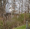
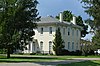
Lyman Allen House and Barn
November 18, 1976 (#76001420 ) 9930 Lancaster-Circleville Rd SW 39°41′48″N 82°47′40″W / 39.696667°N 82.794444°W / 39.696667; -82.794444 (Lyman Allen House and Barn ) Amanda Township
2
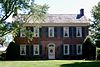
John Artz Farmhouse
April 23, 1987 (#87000644 ) 5125 Duffy Rd., east of Lancaster 39°41′58″N 82°30′09″W / 39.69939°N 82.50259°W / 39.69939; -82.50259 (John Artz Farmhouse ) Berne Township
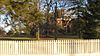
3
November 26, 1980 (#80002995 ) 350 W. Main St. 39°39′04″N 82°45′04″W / 39.651111°N 82.751111°W / 39.651111; -82.751111 (Barr House ) Amanda
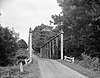
4
John Bright Covered Bridge
May 28, 1975 (#75001393 ) Spans Fetters Run on the Ohio University Lancaster campus[6] 39°44′15″N 82°35′05″W / 39.737595°N 82.584731°W / 39.737595; -82.584731 (John Bright Covered Bridge ) Lancaster Moved from its original location, 2.5 mi (4.0 km) southwest of Baltimore, bringing Bish Rd. NW over Poplar Creek
5
John Bright No. 1 Iron Bridge
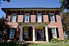
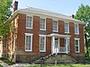
September 20, 1978 (#78002060 ) Spans Fetters Run on the Ohio University Lancaster campus[6] 39°44′11″N 82°35′05″W / 39.736492°N 82.584689°W / 39.736492; -82.584689 (John Bright No. 1 Iron Bridge ) Lancaster Moved from its original location, 2 mi (3.2 km) northeast of Carroll on Havensport Rd.
6
October 1, 1974 (#74001478 ) 1934 Cold Spring Dr. 39°44′15″N 82°37′09″W / 39.7375°N 82.619167°W / 39.7375; -82.619167 (Samuel Bush House ) Lancaster
7
July 24, 1972 (#72001006 ) 3375 Cincinnati-Zanesville Rd., SW., southwest of Lancaster 39°40′59″N 82°39′46″W / 39.683056°N 82.662778°W / 39.683056; -82.662778 (Chestnut Ridge Farm ) Hocking Township
8
Upload image October 25, 1972 (#72001007 ) 1445 Cincinnati-Zanesville Rd., SW. (U.S. Route 22 ), southwest of Lancaster 39°41′56″N 82°37′45″W / 39.698889°N 82.629167°W / 39.698889; -82.629167 (Concord Hall ) Hocking Township
9
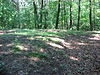
Coon Hunters Mound
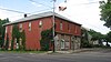
May 2, 1974 (#74001475 ) Grounds of the Central Ohio Coonhunters Association, 6995 Coonpath Rd.[7] Bloom Township Near Carroll
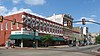
10
November 29, 1979 (#79001833 ) Crawfis and Old Sugar Grove Rds., north of Sugar Grove 39°40′46″N 82°33′28″W / 39.67955°N 82.55768°W / 39.67955; -82.55768 (Crawfis Institute ) Berne Township website
11
Upload image June 11, 2021 (#100006636 ) 5900 B.I.S. Rd. 39°38′34″N 82°37′34″W / 39.6428°N 82.6262°W / 39.6428; -82.6262 (Dairy Barn–Boys' Industrial School ) Lancaster
12
August 8, 1985 (#85001691 ) 7640 Main St. 39°45′49″N 82°26′52″W / 39.763611°N 82.447778°W / 39.763611; -82.447778 (Dilger Store ) West Rushville Demolished (the photo shows the empty lot)
13
March 15, 1982 (#82003566 ) 660 N. Hill Rd. 39°53′57″N 82°45′56″W / 39.899167°N 82.765556°W / 39.899167; -82.765556 (J.H. Dovel Farm ) Pickerington
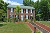
14
September 2, 1993 (#93000890 ) 380 W. Columbus St. 39°53′05″N 82°45′56″W / 39.884722°N 82.765556°W / 39.884722; -82.765556 (Dovel-Bowers House ) Pickerington
15
Upload image June 11, 2021 (#100006637 ) 5900 B.I.S. Rd. 39°38′32″N 82°37′33″W / 39.6422°N 82.6258°W / 39.6422; -82.6258 (Drill Hall-Boys' Industrial School ) Lancaster
16
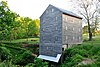
Upload image July 12, 1974 (#74001476 ) Northeast of Carroll[8] Greenfield Township
17
Ety Habitation Site Upload image July 12, 1974 (#74001477 ) Northeast of Carroll[8] Greenfield Township
18
December 22, 2008 (#08001196 ) 1743 E. Main St. 39°42′53″N 82°33′49″W / 39.714839°N 82.563589°W / 39.714839; -82.563589 (Fairfield County Children's Home ) Lancaster
19
March 26, 2020 (#100005128 ) 1587 Granville Pike and 1651 Lancaster-Newark Rd. NE 39°44′22″N 82°35′17″W / 39.7394°N 82.5881°W / 39.7394; -82.5881 (Fairfield County Infirmary ) Lancaster
20
Fortner Mounds I, II Upload image July 12, 1974 (#74001481 ) Northeast of Pickerington[8] Violet Township
21
May 12, 1997 (#97000373 ) 12310 Lancaster-Newark Rd., west of Millersport 39°54′15″N 82°33′35″W / 39.904167°N 82.559722°W / 39.904167; -82.559722 (John Gill Farmstead ) Walnut Township
22
Hizey Covered Bridge
October 8, 1976 (#76001423 ) Private drive at 12549 Tollgate Rd.[9] 39°54′53″N 82°42′33″W / 39.9146°N 82.7092°W / 39.9146; -82.7092 (Hizey Covered Bridge ) Violet Township Moved from its original location east of Pickerington
23
June 16, 1983 (#83001965 ) 7660 Main St 39°45′50″N 82°26′51″W / 39.763750°N 82.447500°W / 39.763750; -82.447500 (Joseph Ijams House ) West Rushville
24
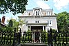
Lancaster Historic District
August 11, 1983 (#83003438 ) Roughly bounded by 5th Ave., Penn Central railroad tracks, U.S. Route 33 , and Tennant St. 39°42′49″N 82°35′54″W / 39.713611°N 82.598333°W / 39.713611; -82.598333 (Lancaster Historic District ) Lancaster
25
September 10, 1987 (#87001560 ) Roughly bounded by the Hocking River , W. Fair Ave., and Ety Rd. 39°43′43″N 82°38′18″W / 39.728611°N 82.638333°W / 39.728611; -82.638333 (Lancaster Methodist Episcopal Camp Ground Historic District ) Lancaster
26
February 28, 1979 (#79001830 ) W. Main St. from Columbus to Broad St. 39°42′50″N 82°36′12″W / 39.713889°N 82.603333°W / 39.713889; -82.603333 (Lancaster West Main Street Historic District ) Lancaster
27
September 10, 1974 (#74001480 ) Off Pickerington-Lockville Rd. in Lockville 39°49′02″N 82°44′11″W / 39.817276°N 82.736343°W / 39.817276; -82.736343 (Lockville Canal Locks ) Violet Township
28
March 30, 1978 (#78002061 ) 319 N. High St. 39°42′59″N 82°35′58″W / 39.716389°N 82.599444°W / 39.716389; -82.599444 (William Medill House ) Lancaster
29
May 22, 1978 (#78002058 ) 370 Pleasantville Rd. 39°48′56″N 82°35′18″W / 39.815556°N 82.588333°W / 39.815556; -82.588333 (Miller Farm ) Walnut Township
30
May 5, 1978 (#78002059 ) Southeast of Baltimore at 7079 Millersport Rd. 39°49′36″N 82°33′04″W / 39.826667°N 82.551111°W / 39.826667; -82.551111 (Henry Musser House ) Walnut Township
31
Old Maid's Orchard Mound Upload image July 15, 1974 (#74001479 ) In Chestnut Ridge Metro Park, near Lithopolis[10] Bloom Township
32
September 2, 1993 (#93000892 ) 15 W. Columbus St. 39°53′02″N 82°45′13″W / 39.883889°N 82.753611°W / 39.883889; -82.753611 (Pickerington Carnegie Library ) Pickerington
33
July 26, 1990 (#90001119 ) 50 N. Center St. 39°53′07″N 82°45′15″W / 39.885278°N 82.754167°W / 39.885278; -82.754167 (Pickerington Depot ) Pickerington
34
June 16, 1983 (#83001964 ) 2140 Bickel Church Rd., northeast of Baltimore 39°52′14″N 82°32′40″W / 39.870556°N 82.544444°W / 39.870556; -82.544444 (Pugh-Kittle House ) Walnut Township
35
July 30, 1975 (#75001395 ) West of Lancaster at 8325 Lancaster-Circleville Rd. (State Route 188 ) 39°42′26″N 82°45′41″W / 39.707222°N 82.761389°W / 39.707222; -82.761389 (Valentine Reber House ) Amanda Township
36
June 1, 1990 (#90000850 ) Rock Mill Rd. on the southern bank of the Hocking River , northwest of Lancaster 39°44′54″N 82°42′47″W / 39.748333°N 82.713056°W / 39.748333; -82.713056 (Rock Mill ) Bloom Township
37
Rock Mill Covered Bridge
April 26, 1976 (#76001424 ) State Route 41 at Rock Mill39°44′56″N 82°42′48″W / 39.748889°N 82.713333°W / 39.748889; -82.713333 (Rock Mill Covered Bridge ) Bloom Township
38
Upload image July 30, 1975 (#75001396 ) 8691 Royalton Rd., SW. 39°43′33″N 82°46′02″W / 39.725833°N 82.767222°W / 39.725833; -82.767222 (Royalton House ) Amanda Township
39
November 24, 1980 (#80002996 ) Bremen Ave., Main and Market Sts. 39°45′51″N 82°25′51″W / 39.764167°N 82.430833°W / 39.764167; -82.430833 (Rushville Historic District ) Rushville
40
St. Peter's Evangelical Lutheran Church
April 16, 1979 (#79001831 ) Broad and Mullberry Sts. 39°42′59″N 82°36′06″W / 39.716389°N 82.601667°W / 39.716389; -82.601667 (St. Peter's Evangelical Lutheran Church ) Lancaster
41
Theodore B. Schaer Mound Upload image June 20, 1975 (#75001394 ) Southeast of Canal Winchester[8] Violet Township
42
John Sherman Birthplace
October 15, 1966 (#66000609 ) 137 E. Main St. 39°42′50″N 82°36′02″W / 39.71394°N 82.6005°W / 39.71394; -82.6005 (John Sherman Birthplace ) Lancaster
43
July 24, 1972 (#72001008 ) Roughly the area along Broad and High Sts. between Mulberry and Chestnut Sts. 39°42′52″N 82°36′02″W / 39.714444°N 82.600556°W / 39.714444; -82.600556 (Square 13 Historic District ) Lancaster
44
May 6, 1976 (#76001422 ) 720 Lincoln Ave. (now Mithoff Dr.) 39°42′32″N 82°37′00″W / 39.708889°N 82.616667°W / 39.708889; -82.616667 (Tallmadge-Mithoff House ) Lancaster
45
Tarlton Cross Mound
November 10, 1970 (#70000489 ) , northwest of Tarlton[11] 39°33′44″N 82°47′07″W / 39.5622°N 82.7853°W / 39.5622; -82.7853 (Tarlton Cross Mound ) Clear Creek Township
46
October 26, 1972 (#72001009 ) Southwest of Lancaster on U.S. Route 22 39°41′34″N 82°38′42″W / 39.692778°N 82.645°W / 39.692778; -82.645 (Willow Lane Farm ) Hocking Township
47
Winegardner Village
July 30, 1974 (#74001482 ) On a bluff above Little Rush Creek, east of the junction of Gun Barrel and Miller Siding Rds.[12] 39°47′55″N 82°26′21″W / 39.7986°N 82.4392°W / 39.7986; -82.4392 (Winegardner Village ) Richland Township Near Rushville