1
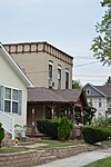
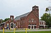
Ashland Avenue Baptist Church
November 26, 1980 (#80003144 ) Ashland and Woodruff Sts. 41°39′38″N 83°33′00″W / 41.6606°N 83.5500°W / 41.6606; -83.5500 (Ashland Avenue Baptist Church ) Toledo
2
B'nai Israel Synagogue
October 6, 2005 (#05001145 ) 2146 N. 12th St. at Bancroft St. 41°39′50″N 83°32′23″W / 41.6639°N 83.5397°W / 41.6639; -83.5397 (B'nai Israel Synagogue ) Toledo
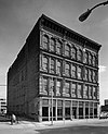
3
May 29, 1975 (#75001468 ) 601 Washington St. 41°38′54″N 83°32′27″W / 41.6483°N 83.5408°W / 41.6483; -83.5408 (Berdan Building ) Toledo
4
October 13, 1983 (#83004316 ) Birckhead Pl. 41°40′30″N 83°32′42″W / 41.6750°N 83.5450°W / 41.6750; -83.5450 (Birckhead Place Historic District ) Toledo
5
August 8, 1996 (#96000834 ) Roughly bounded by Genesee, York, Esther, Magyar, Consaul, and the Conrail tracks 41°39′42″N 83°29′47″W / 41.6617°N 83.4964°W / 41.6617; -83.4964 (Birmingham Historic District ) Toledo
6
May 27, 1975 (#75001469 ) 120-124 St. Clair St. 41°38′57″N 83°32′10″W / 41.6492°N 83.5361°W / 41.6492; -83.5361 (R. Brand and Company ) Toledo
7
June 17, 1994 (#94000595 ) 1133 Grasser St. 41°37′49″N 83°29′18″W / 41.6303°N 83.4883°W / 41.6303; -83.4883 (Brandville School ) Oregon
8
Upload image December 7, 2020 (#100005856 ) 622 Jefferson Ave. 41°39′05″N 83°32′19″W / 41.6515°N 83.5387°W / 41.6515; -83.5387 (The Broer-Freeman Building ) Toledo
9
November 29, 1984 (#84000459 ) Roughly bounded by Cherry St. and Central and Franklin Aves. 41°40′41″N 83°32′52″W / 41.6781°N 83.5478°W / 41.6781; -83.5478 (Bronson Place ) Toledo
10
November 1, 1977 (#77001074 ) 719-723 Jefferson St. 41°39′06″N 83°32′24″W / 41.6517°N 83.5400°W / 41.6517; -83.5400 (Burt's Theater ) Toledo
11
June 1, 1982 (#82003609 ) Bush and Erie Sts. 41°39′52″N 83°31′12″W / 41.6644°N 83.5200°W / 41.6644; -83.5200 (Bush Street Historic District ) Toledo
12
April 15, 1982 (#82003610 ) 1110 Jefferson Ave. 41°39′13″N 83°32′33″W / 41.6536°N 83.5425°W / 41.6536; -83.5425 (Central YMCA ) Toledo
13
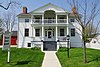
December 17, 1969 (#69000146 ) River and Farnsworth Rds. 41°29′57″N 83°43′03″W / 41.4993°N 83.7175°W / 41.4993; -83.7175 (Columbian House ) Waterville
14
October 24, 1997 (#97001240 ) 505 Jefferson Ave. 41°39′02″N 83°32′15″W / 41.6506°N 83.5375°W / 41.6506; -83.5375 (Commodore Perry Hotel ) Toledo
15
May 3, 1976 (#76001473 ) 107-117 Main St. 41°38′54″N 83°31′22″W / 41.6483°N 83.5228°W / 41.6483; -83.5228 (East Side Commercial Block ) Toledo
16
August 8, 1996 (#96000831 ) Roughly bounded by Front, Platt, Starr, and Spring Grove 41°37′38″N 83°30′44″W / 41.6272°N 83.5122°W / 41.6272; -83.5122 (East Toledo Historic District ) Toledo
17
April 6, 1978 (#78002120 ) 202 and 204 E. Dudley St. 41°33′48″N 83°39′06″W / 41.5633°N 83.6517°W / 41.5633; -83.6517 (Eckenrode and Breisach Houses ) Maumee
18
May 29, 1998 (#98000601 ) Roughly bounded by W. Bancroft, Lawrence, Oakwood, Hoag, and Detroit Sts. 41°39′38″N 83°33′54″W / 41.6606°N 83.5650°W / 41.6606; -83.5650 (Englewood Historic District ) Toledo
19
Fallen Timbers Battlefield
October 15, 1966 (#66000616 ) 2 mi (3.2 km) west of Maumee on U.S. Route 24 41°32′39″N 83°41′51″W / 41.5442°N 83.6975°W / 41.5442; -83.6975 (Fallen Timbers Battlefield ) Monclova Township
20
First Church of Christ, Scientist
November 29, 1978 (#78002125 ) 2704 Monroe St. 41°39′43″N 83°33′55″W / 41.6619°N 83.5653°W / 41.6619; -83.5653 (First Church of Christ, Scientist ) Toledo
21
First Presbyterian Church of Maumee Chapel
August 13, 1973 (#73001498 ) 200 E. Broadway 41°33′41″N 83°39′03″W / 41.5614°N 83.6507°W / 41.5614; -83.6507 (First Presbyterian Church of Maumee Chapel ) Maumee
22
May 18, 1989 (#89000429 ) 106 E. Harrison Ave. 41°33′40″N 83°38′54″W / 41.561111°N 83.648333°W / 41.561111; -83.648333 (Forsythe-Puhl House ) Maumee
23
July 23, 1973 (#73001501 ) Bounded by Summit, Monroe, and Water Sts. and Jefferson Ave. 41°38′57″N 83°32′06″W / 41.649167°N 83.535000°W / 41.649167; -83.535000 (Fort Industry Square ) Toledo
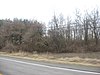
24
Fort Miamis Site
June 18, 1975 (#75001466 ) Along the Maumee River at Fort Miamis State Memorial[6] 41°34′22″N 83°37′35″W / 41.572778°N 83.626389°W / 41.572778; -83.626389 (Fort Miamis Site ) Maumee
25
March 3, 1983 (#83002001 ) 1413 Walnut St. 41°39′50″N 83°32′09″W / 41.663889°N 83.535972°W / 41.663889; -83.535972 (Peter Gendron House ) Toledo
26
July 18, 1975 (#75001474 ) 133 N. 4th St. 41°30′07″N 83°43′16″W / 41.501806°N 83.721111°W / 41.501806; -83.721111 (Gillett-Shoemaker-Welsh House ) Waterville
27
Governor's Inn
October 18, 1974 (#74001557 ) 301 River Rd. 41°33′52″N 83°38′46″W / 41.564444°N 83.646111°W / 41.564444; -83.646111 (Governor's Inn ) Maumee
28
May 22, 1978 (#78002121 ) 228 E. Broadway 41°33′42″N 83°38′59″W / 41.561667°N 83.649611°W / 41.561667; -83.649611 (Peck Griswold House ) Maumee
29
May 22, 1978 (#78002122 ) 405 E. Broadway 41°33′47″N 83°38′50″W / 41.563056°N 83.647222°W / 41.563056; -83.647222 (Hanson House ) Maumee
30
July 1, 1975 (#75001475 ) North of Waterville at 625 Canal Rd. 41°30′34″N 83°43′09″W / 41.509444°N 83.719167°W / 41.509444; -83.719167 (Liberty Whitcomb Haskins House ) Waterville
31
Hillcrest Hotel
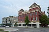
September 18, 1998 (#98001179 ) 1603 Madison Ave. 41°39′23″N 83°32′46″W / 41.656389°N 83.546111°W / 41.656389; -83.546111 (Hillcrest Hotel ) Toledo
32
July 16, 1973 (#73001499 ) 322 E. Broadway 41°33′44″N 83°38′53″W / 41.562222°N 83.648194°W / 41.562222; -83.648194 (House Of Four Pillars ) Maumee
33
March 30, 1978 (#78002123 ) 114 E. Harrison St. 41°33′37″N 83°39′05″W / 41.560278°N 83.651389°W / 41.560278; -83.651389 (Isaac Hull Store ) Maumee
34
Hull-Wolcott House
January 26, 1970 (#70000506 ) 1031 River Rd. 41°34′20″N 83°38′21″W / 41.572222°N 83.639167°W / 41.572222; -83.639167 (Hull-Wolcott House ) Maumee
35
March 24, 1993 (#93000153 ) Roughly bounded by Erie, Monroe, Superior and Market Sts. 41°38′52″N 83°32′28″W / 41.647778°N 83.541111°W / 41.647778; -83.541111 (Huron-Superior Streets Warehouse-Produce Historic District ) Toledo
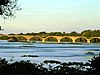
36
Interurban Bridge
June 19, 1972 (#72001036 ) 1 mi (1.6 km) south of Waterville over the Maumee River 41°29′11″N 83°43′42″W / 41.486389°N 83.728333°W / 41.486389; -83.728333 (Interurban Bridge ) Waterville Extends into Wood County
37
Inverness Club
May 10, 1993 (#93000398 ) 4601 Dorr St. 41°39′00″N 83°39′00″W / 41.650000°N 83.650000°W / 41.650000; -83.650000 (Inverness Club ) Toledo
38
August 15, 1996 (#96000868 ) 1302 Parkside Boulevard 41°39′11″N 83°35′38″W / 41.653056°N 83.593889°W / 41.653056; -83.593889 (Ira Apartments ) Toledo Demolished in mid-February 2007[citation needed
39
September 16, 1992 (#92001159 ) 8460 S. River Rd. 41°28′55″N 83°44′48″W / 41.481944°N 83.746667°W / 41.481944; -83.746667 (John Isham Farmstead ) Waterville
40
August 9, 1982 (#82005388 ) 8460 S. River Rd. 41°28′54″N 83°44′47″W / 41.481556°N 83.746389°W / 41.481556; -83.746389 (John Isham House ) Waterville
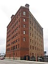
41
Upload image December 23, 2019 (#100004779 ) 443 10th St. 41°39′23″N 83°32′19″W / 41.6565°N 83.5385°W / 41.6565; -83.5385 (Landers Brothers Company Building ) Toledo
42
August 4, 1995 (#95001001 ) 513 Adams St. at its junction with Huron St. 41°39′11″N 83°32′08″W / 41.653056°N 83.535556°W / 41.653056; -83.535556 (Lasalle, Koch and Company Department Store ) Toledo
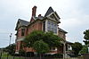
43
Edward D. Libbey House
May 4, 1983 (#83004379 ) 2008 Scottwood Ave. 41°38′32″N 83°33′29″W / 41.642222°N 83.558056°W / 41.642222; -83.558056 (Edward D. Libbey House ) Toledo
44
Edward Drummond Libbey High School
September 15, 2011 (#11000672 ) 1250 Western Ave. 41°38′07″N 83°34′17″W / 41.635278°N 83.571389°W / 41.635278; -83.571389 (Edward Drummond Libbey High School ) Toledo
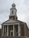
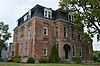
45
Lucas County Courthouse and Jail
May 11, 1973 (#73002295 ) Courthouse Sq. and 810-814 Jackson 41°39′19″N 83°32′14″W / 41.655278°N 83.537222°W / 41.655278; -83.537222 (Lucas County Courthouse and Jail ) Toledo
46
October 17, 1997 (#97001224 ) 2101 and 2155 Arlington Ave. 41°37′21″N 83°35′42″W / 41.622500°N 83.595000°W / 41.622500; -83.595000 (Lucas County Hospital and Nurse's Home ) Toledo
47
June 28, 1974 (#74001558 ) Mill Rd. in Providence Park 41°24′55″N 83°51′45″W / 41.415278°N 83.8625°W / 41.415278; -83.8625 (Isaac R. Ludwig Historical Mill ) Providence Township
48
June 26, 1998 (#86003829 ) Roughly bounded by Madison, Adams and Huron Sts.; also 311, 315-317, 319-323, 325-327, 329, 331-333, 335 North Superior St. 41°39′08″N 83°32′12″W / 41.652222°N 83.536667°W / 41.652222; -83.536667 (Madison Avenue Historic District ) Toledo Boundary increase approved September 2, 2021
49
January 18, 1974 (#09000099 ) Roughly W. Harrison, W. Broadway, Cass, Allen, and W. Dudley 41°33′45″N 83°39′14″W / 41.562500°N 83.653889°W / 41.562500; -83.653889 (Maumee Historic District ) Maumee
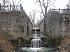
50
Maumee Sidecut
April 11, 1973 (#73001500 ) North of the Maumee River , southwest of Ewing Island 41°33′30″N 83°39′36″W / 41.558333°N 83.66°W / 41.558333; -83.66 (Maumee Sidecut ) Maumee
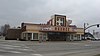
51
April 1, 1998 (#98000318 ) 601 Conant St. 41°33′53″N 83°39′20″W / 41.564722°N 83.655556°W / 41.564722; -83.655556 (Maumee Theater ) Maumee
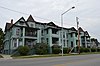
52
March 1, 1984 (#84003766 ) Conant, Wayne, and Dudley Sts. 41°33′44″N 83°39′15″W / 41.562222°N 83.654167°W / 41.562222; -83.654167 (Maumee Uptown Historic District ) Maumee
53
December 12, 1976 (#76001474 ) 513-623 Monroe St. 41°39′00″N 83°32′24″W / 41.650000°N 83.540000°W / 41.650000; -83.540000 (Monroe Street Commercial Buildings ) Toledo
54
May 29, 1975 (#75001476 ) 4 S. River Rd. 41°29′56″N 83°43′03″W / 41.498889°N 83.717500°W / 41.498889; -83.717500 (Morehouse-Downes House ) Waterville
55
March 4, 1971 (#71000644 ) 301 Broadway 41°38′28″N 83°32′29″W / 41.641111°N 83.541389°W / 41.641111; -83.541389 (Albert Neukom House ) Toledo
56
Ohio Theatre
March 29, 2006 (#06000198 ) 3114 Lagrange St. 41°40′45″N 83°32′26″W / 41.679167°N 83.540556°W / 41.679167; -83.540556 (Ohio Theatre ) Toledo
57
February 23, 1972 (#72001030 ) 13th St. between Madison and Jefferson Aves. 41°39′17″N 83°32′39″W / 41.654722°N 83.544167°W / 41.654722; -83.544167 (Old Central Post Office ) Toledo
58
Old West End District
March 14, 1973 (#73001503 ) Roughly bounded by Delaware, Collingwood, and Glenwood Aves. and Grove Pl.; also roughly bounded by Glenwood, Glover, Ashland, Collingwood, and Central Aves. 41°39′45″N 83°36′41″W / 41.6625°N 83.611389°W / 41.6625; -83.611389 (Old West End District ) Toledo Second set of boundaries represents a boundary increase of March 30, 1984
59
Upload image December 10, 2018 (#100003209 ) 713-717 Jefferson Ave. 41°39′06″N 83°32′23″W / 41.6518°N 83.5397°W / 41.6518; -83.5397 (Ontario Building ) Toledo
60
Upload image December 23, 2019 (#100004780 ) 15 South Ontario St. 41°38′55″N 83°32′34″W / 41.6487°N 83.5427°W / 41.6487; -83.5427 (The Overmyer Building ) Toledo
61
May 29, 1975 (#75001477 ) 144 N. River Rd. 41°30′06″N 83°43′00″W / 41.501667°N 83.716667°W / 41.501667; -83.716667 (Pray-Starkweather House ) Waterville
62
August 13, 1975 (#75001467 ) Court and Main Sts. and Ludwig and Providence-Neopolis Rds. in Providence 41°25′07″N 83°52′24″W / 41.418611°N 83.873333°W / 41.418611; -83.873333 (Providence Historic District ) Providence Township
63
Pythian Castle
February 23, 1972 (#72001032 ) 801 Jefferson Ave. 41°39′07″N 83°32′25″W / 41.651944°N 83.540278°W / 41.651944; -83.540278 (Pythian Castle ) Toledo
64
April 20, 1978 (#78002124 ) 511-513 White St. 41°33′57″N 83°38′59″W / 41.565833°N 83.649722°W / 41.565833; -83.649722 (Henry Reed, Jr., House ) Maumee
65
Riverview
July 3, 2012 (#12000394 ) 200 N. St. Clair St. and 215 and 239 Summit St. 41°39′02″N 83°32′06″W / 41.650556°N 83.535000°W / 41.650556; -83.535000 (Riverview ) Toledo
66
April 21, 1983 (#83002002 ) 1829-1837 Summit St. 41°39′57″N 83°30′40″W / 41.665833°N 83.511111°W / 41.665833; -83.511111 (Riverview Apartments ) Toledo
67
St. Ann Roman Catholic Church Complex
May 5, 1983 (#83002003 ) 1105 W. Bancroft and 1120 Horace Sts. 41°39′47″N 83°34′12″W / 41.663056°N 83.570000°W / 41.663056; -83.570000 (St. Ann Roman Catholic Church Complex ) Toledo
68
May 29, 1975 (#75001471 ) Both sides of St. Clair St. from Perry St. to the southern side of Lafayette St.; 28 N. St Clair, 23-29 & 31 Summit 41°38′48″N 83°32′20″W / 41.646667°N 83.538889°W / 41.646667; -83.538889 (St. Clair Street Historic District ) Toledo Second set of addresses represent a boundary adjustment in 2014.
69
St. Patrick's Catholic Church
February 23, 1972 (#72001033 ) 13th St. and Avondale Ave. 41°38′56″N 83°32′45″W / 41.648889°N 83.545833°W / 41.648889; -83.545833 (St. Patrick's Catholic Church ) Toledo
70
March 13, 1987 (#87000465 ) 600 and 700 blocks of S. Saint Clair St. 41°38′22″N 83°32′53″W / 41.639444°N 83.548056°W / 41.639444; -83.548056 (Saint Peter and Saint Paul Historic District-Oliver's Second addition ) Toledo
71
April 30, 1976 (#76001475 ) 413-423 Jefferson Ave. 41°39′01″N 83°32′13″W / 41.650278°N 83.536944°W / 41.650278; -83.536944 (Secor Hotel ) Toledo
72
June 11, 1979 (#79003108 ) 311 Bush St. 41°39′41″N 83°31′05″W / 41.661389°N 83.518056°W / 41.661389; -83.518056 (Joseph K. Secor House ) Toledo
73
April 21, 1983 (#83002004 ) 514-526 Madison Ave. 41°39′08″N 83°32′11″W / 41.652222°N 83.536389°W / 41.652222; -83.536389 (Spitzer Building ) Toledo
74
August 8, 1996 (#96000832 ) Roughly bounded by Mason, Spring Grove, Greenwood, and Conrail tracks 41°38′32″N 83°30′26″W / 41.642222°N 83.507222°W / 41.642222; -83.507222 (Spring Grove Historic District ) Toledo
75
May 29, 1975 (#75001472 ) 36 S. Erie St. 41°38′52″N 83°32′33″W / 41.647778°N 83.542500°W / 41.647778; -83.542500 (Standart-Simmons Hardware Company ) Toledo
76
Successful Sales (Oliver House Hotel)
May 6, 1971 (#71000645 ) 27 Broadway 41°38′36″N 83°32′18″W / 41.643333°N 83.538333°W / 41.643333; -83.538333 (Successful Sales (Oliver House Hotel) ) Toledo
77
December 1, 1978 (#78002127 ) 14th St. and Madison Ave. 41°39′20″N 83°32′40″W / 41.655556°N 83.544444°W / 41.655556; -83.544444 (Toledo Club ) Toledo
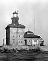
78
Toledo Harbor Light
August 4, 1983 (#83002005 ) Toledo Harbor 41°43′04″N 83°25′17″W / 41.717778°N 83.421389°W / 41.717778; -83.421389 (Toledo Harbor Light ) Jerusalem Township
79
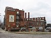
September 21, 1989 (#89001454 ) Roughly bounded by Central Ave., Cherry St., Franklin Ave., Bancroft St., and Collingwood Ave. 41°40′04″N 83°32′59″W / 41.667778°N 83.549722°W / 41.667778; -83.549722 (Toledo Olde Towne Historic District ) Toledo
80
June 19, 2003 (#03000555 ) 300 Water St. 41°39′02″N 83°31′57″W / 41.650556°N 83.532500°W / 41.650556; -83.532500 (Toledo Traction Company Power Station ) Toledo
81
Toledo Yacht Club
December 12, 1976 (#76001476 ) Bay View Park 41°41′35″N 83°28′32″W / 41.693056°N 83.475556°W / 41.693056; -83.475556 (Toledo Yacht Club ) Toledo
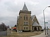
82
Trinity Episcopal Church
December 29, 1983 (#83004317 ) 316 Adams St. 41°39′10″N 83°32′00″W / 41.652778°N 83.533333°W / 41.652778; -83.533333 (Trinity Episcopal Church ) Toledo
83
United States Courthouse and Custom House
July 17, 2013 (#13000501 ) 1716 Spielbusch Ave. 41°39′27″N 83°32′10″W / 41.6575°N 83.5361°W / 41.6575; -83.5361 (United States Courthouse and Custom House ) Toledo
84
May 19, 1987 (#87000686 ) 405-419 Saint Clair and 402-412 Adams 41°39′11″N 83°32′01″W / 41.653056°N 83.533611°W / 41.653056; -83.533611 (Valentine Theater Building ) Toledo
85
Vistula Historic District
December 6, 1978 (#78002128 ) Roughly bounded by Champlain, Summit, Walnut and Magnolia Sts. 41°38′32″N 83°30′26″W / 41.642222°N 83.507222°W / 41.642222; -83.507222 (Vistula Historic District ) Toledo
86
December 12, 1976 (#76001477 ) 3rd St. 41°29′59″N 83°43′12″W / 41.499722°N 83.720000°W / 41.499722; -83.720000 (Waterville Commercial District ) Waterville
87
August 4, 1983 (#83002006 ) West Sister Island 41°44′13″N 83°06′38″W / 41.736944°N 83.110556°W / 41.736944; -83.110556 (West Sister Island Light ) Jerusalem Township
88
February 3, 1986 (#86000208 ) Roughly bounded by Parkside Boulevard, Bancroft St., Upton Ave., and Oakwood Ave. and Allenby Rd. 41°39′35″N 83°35′29″W / 41.659722°N 83.591389°W / 41.659722; -83.591389 (Westmoreland Historic District ) Toledo
89
Woodlawn Cemetery
November 19, 1998 (#98001396 ) 1502 W. Central Ave. 41°40′53″N 83°34′46″W / 41.681389°N 83.579444°W / 41.681389; -83.579444 (Woodlawn Cemetery ) Toledo
90
October 5, 1978 (#78002129 ) 1822 Cherry St. 41°39′58″N 83°32′22″W / 41.666111°N 83.539444°W / 41.666111; -83.539444 (Dr. John A. Wright House ) Toledo
91
August 8, 1996 (#96000833 ) Roughly bounded by Oak, 2nd, Euclid, Starr, White, Delence, and Nevada 41°38′38″N 83°31′16″W / 41.643889°N 83.521111°W / 41.643889; -83.521111 (Yondota Historic District ) Toledo