National Register of Historic Places listings in Fulton County, Ohio

Location of Fulton County in Ohio
This is a list of the National Register of Historic Places listings in Fulton County, Ohio.
It is intended to be a complete list of the properties on the National Register of Historic Places in Fulton County, Ohio, United States. The locations of National Register properties for which the latitude and longitude coordinates are included below, may be seen in an online map.[1]
There are 7 properties listed on the National Register in the county.
- This National Park Service list is complete through NPS recent listings posted February 11, 2022.[2]
Current listings[]
| [3] | Name on the Register[4] | Image | Date listed[5] | Location | City or town | Description |
|---|---|---|---|---|---|---|
| 1 | George S. Clement House |  |
April 21, 1983 (#83001973) |
137 Clinton St. 41°32′57″N 84°08′35″W / 41.5492°N 84.1431°W | Wauseon | |
| 2 | Fulton County Courthouse | 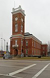 |
May 7, 1973 (#73001447) |
S. Fulton and Chestnut Sts. 41°32′46″N 84°08′27″W / 41.5460°N 84.1408°W | Wauseon | |
| 3 |  |
February 18, 2021 (#100006149) |
401 1/2 Main St. 41°34′27″N 84°00′20″W / 41.5741°N 84.0056°W | Delta | ||
| 4 | Goll Homestead |  |
October 26, 2005 (#05001185) |
26093 Township Road F northwest of Archbold 41°33′22″N 84°21′51″W / 41.5561°N 84.3642°W | German Township | |
| 5 | Jones-Read-Touvelle House |  |
May 8, 1987 (#87000632) |
435 E. Park St. 41°32′35″N 84°08′22″W / 41.5431°N 84.1394°W | Wauseon | |
| 6 |  |
March 11, 1993 (#93000151) |
Southern side of Depot St., between Fulton and Brunell Sts. 41°32′50″N 84°08′13″W / 41.5472°N 84.1369°W | Wauseon | ||
| 7 |  |
December 31, 1974 (#74001500) |
South of Winameg on the northern banks of Bad Creek[6] 41°37′17″N 84°04′04″W / 41.6215°N 84.0679°W | Pike Township |

See also[]
| Wikimedia Commons has media related to National Register of Historic Places in Fulton County, Ohio. |
- List of National Historic Landmarks in Ohio
- Listings in neighboring counties: Henry, Hillsdale (MI), Lenawee (MI), Lucas, Williams
- National Register of Historic Places listings in Ohio
References[]
- ^ The latitude and longitude information provided in this table was derived originally from the National Register Information System, which has been found to be fairly accurate for about 99% of listings. Some locations in this table may have been corrected to current GPS standards.
- ^ National Park Service, United States Department of the Interior, "National Register of Historic Places: Weekly List Actions", retrieved February 11, 2022.
- ^ Numbers represent an alphabetical ordering by significant words. Various colorings, defined here, differentiate National Historic Landmarks and historic districts from other NRHP buildings, structures, sites or objects.
- ^ "National Register Information System". National Register of Historic Places. National Park Service. April 24, 2008.
- ^ The eight-digit number below each date is the number assigned to each location in the National Register Information System database, which can be viewed by clicking the number.
- ^ Location derived from Mills, William C. Archeological Atlas of Ohio. Columbus: Ohio State Archeological and Historical Society, 1914, page 26 and plate 26. The NRIS lists the site as "Address Restricted".

Municipalities and communities of Fulton County, Ohio, United States | ||
|---|---|---|
| City |  | |
| Villages | ||
| Townships | ||
| CDPs | ||
| Other communities | ||
| Ghost towns | ||
| Footnotes | ‡This populated place also has portions in an adjacent county or counties | |
| ||
Categories:
- National Register of Historic Places in Fulton County, Ohio
- Lists of National Register of Historic Places in Ohio by county