[3] Name on the Register[4]
Image
Date listed[5]
Location
City or town
Description
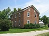
1
Cassella Catholic Church and Rectory
July 26, 1979 (#79002822 ) State Route 119 in Cassella40°24′24″N 84°33′03″W / 40.406667°N 84.550833°W / 40.406667; -84.550833 (Cassella Catholic Church and Rectory ) Marion Township
2
November 30, 1982 (#82001474 ) Roughly bounded by Walnut, W. Livingston, Ash, and Warren Sts. 40°32′58″N 84°34′15″W / 40.549444°N 84.570833°W / 40.549444; -84.570833 (Celina Main Street Commercial Historic District ) Celina
3
Chickasaw School and Rectory
July 26, 1979 (#79002848 ) Maple St. 40°26′10″N 84°29′35″W / 40.436111°N 84.493056°W / 40.436111; -84.493056 (Chickasaw School and Rectory ) Chickasaw
4
July 26, 1979 (#79002832 ) E. Main and 2nd Sts. 40°28′49″N 84°37′42″W / 40.480278°N 84.628333°W / 40.480278; -84.628333 (Coldwater Catholic Church Complex ) Coldwater
5
Fort Recovery Site
November 10, 1970 (#70000509 ) State Route 49 40°24′50″N 84°46′51″W / 40.413889°N 84.780833°W / 40.413889; -84.780833 (Fort Recovery Site ) Fort Recovery
6
Matthias Gast House and General Store
December 29, 1978 (#78002139 ) State Route 119 in Maria Stein40°24′28″N 84°28′13″W / 40.407778°N 84.470278°W / 40.407778; -84.470278 (Matthias Gast House and General Store ) Marion Township
7
November 26, 1980 (#80003159 ) 602 W. Market St. 40°32′56″N 84°34′50″W / 40.548889°N 84.580556°W / 40.548889; -84.580556 (Sen. Thomas J. Godfrey House ) Celina
8
Grand Lake St. Marys Lighthouse
June 2, 1982 (#82003614 ) Grand Lake St. Marys-Northwood Addition, east of Celina 40°32′36″N 84°28′53″W / 40.543333°N 84.481389°W / 40.543333; -84.481389 (Grand Lake St. Marys Lighthouse ) Jefferson Township
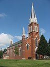
9
Gruenwald Convent
July 26, 1979 (#79002813 ) 0.5 miles south of Cassella 40°24′01″N 84°33′03″W / 40.400278°N 84.550833°W / 40.400278; -84.550833 (Gruenwald Convent ) Marion Township
10
Immaculate Conception Catholic Church Complex
July 26, 1979 (#79002833 ) Anthony and Walnut Sts. 40°33′07″N 84°34′22″W / 40.551944°N 84.572778°W / 40.551944; -84.572778 (Immaculate Conception Catholic Church Complex ) Celina
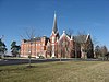
11
Maria Stein Catholic Church and Rectory
July 26, 1979 (#79002828 ) St. John's Rd. and State Route 119 in Maria Stein 40°24′29″N 84°28′22″W / 40.408056°N 84.472778°W / 40.408056; -84.472778 (Maria Stein Catholic Church and Rectory ) Marion Township
12
Maria Stein Convent
May 6, 1976 (#76001490 ) St. John's and Rolfes Rd. in Maria Stein 40°24′57″N 84°28′34″W / 40.415833°N 84.476111°W / 40.415833; -84.476111 (Maria Stein Convent ) Marion Township
13
December 29, 1978 (#78002140 ) S. Main St. 40°40′23″N 84°31′07″W / 40.673056°N 84.518611°W / 40.673056; -84.518611 (Mendon Town Hall ) Mendon
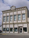
14
February 3, 2022 (#100007396 ) 101 North Wayne St. 40°24′48″N 84°46′47″W / 40.4132°N 84.7796°W / 40.4132; -84.7796 (Morvilius Opera House ) Fort Recovery
15
November 25, 1980 (#80003160 ) 441 E. Market St. 40°32′58″N 84°33′52″W / 40.549333°N 84.564444°W / 40.549333; -84.564444 (Otis Hospital ) Celina
16
July 26, 1979 (#79002823 ) Philothea Rd. in Philothea, between St. Henry and Coldwater 40°27′03″N 84°39′18″W / 40.450833°N 84.655°W / 40.450833; -84.655 (Philothea Catholic Church and Priest House ) Butler Township
17
November 30, 1978 (#78002137 ) 130 E. Market St. 40°32′55″N 84°34′10″W / 40.548611°N 84.569444°W / 40.548611; -84.569444 (Calvin E. Riley House ) Celina
18
St. Aloysius Catholic Church
July 26, 1979 (#79002824 ) U.S. Route 127 and State Route 274 , west of Carthagena40°26′11″N 84°34′12″W / 40.436389°N 84.57°W / 40.436389; -84.57 (St. Aloysius Catholic Church ) Marion Township
19
St. Anthony Catholic Church, Padua
July 26, 1979 (#79002821 ) State Route 49 and St. Anthony Rd. in Padua40°30′32″N 84°47′07″W / 40.508889°N 84.785278°W / 40.508889; -84.785278 (St. Anthony Catholic Church, Padua ) Washington Township
20
July 26, 1979 (#79002842 ) Main St. 40°21′08″N 84°38′45″W / 40.352222°N 84.645833°W / 40.352222; -84.645833 (St. Bernard Catholic Church and Rectory ) Burkettsville
21
St. Charles Seminary and Chapel
July 26, 1979 (#79002840 ) 0.5 miles south of Carthagena, off U.S. Route 127 40°25′57″N 84°33′48″W / 40.4325°N 84.563333°W / 40.4325; -84.563333 (St. Charles Seminary and Chapel ) Marion Township
22
July 26, 1979 (#79002837 ) Cranberry and Ft. Recovery-Minster Rd. in Cranberry Prairie 40°23′34″N 84°34′55″W / 40.392778°N 84.581944°W / 40.392778; -84.581944 (St. Francis Catholic Church and Rectory ) Granville Township
23
St. Henry Catholic Church
July 26, 1979 (#79002829 ) Main St. 40°25′03″N 84°38′15″W / 40.4175°N 84.6375°W / 40.4175; -84.6375 (St. Henry Catholic Church ) St. Henry
24
July 26, 1979 (#79002820 ) Sawmill and St. Joe Rds. in St. Joe 40°25′41″N 84°44′19″W / 40.428056°N 84.738611°W / 40.428056; -84.738611 (St. Joseph Catholic Church and Rectory ) Recovery Township
25
July 26, 1979 (#79002827 ) Junction of Sharpsburg and Meiring Rds. in Sharpsburg 40°22′02″N 84°42′41″W / 40.367222°N 84.711389°W / 40.367222; -84.711389 (St. Paul's Catholic Church and Rectory ) Gibson Township
26
July 26, 1979 (#79002831 ) St. Peter and Philothea Rds. in St. Peter 40°27′03″N 84°44′48″W / 40.450833°N 84.746667°W / 40.450833; -84.746667 (St. Peter Catholic Church and Rectory ) Recovery Township
27
St. Rose Catholic Church Complex
July 26, 1979 (#79002838 ) Main St. in St. Rose 40°24′26″N 84°30′53″W / 40.407222°N 84.514722°W / 40.407222; -84.514722 (St. Rose Catholic Church Complex ) Marion Township
28
St. Sebastian Catholic Church and Rectory
July 26, 1979 (#79002830 ) Sebastian Rd. and State Route 716A in St. Sebastian 40°26′39″N 84°31′00″W / 40.444167°N 84.516667°W / 40.444167; -84.516667 (St. Sebastian Catholic Church and Rectory ) Marion Township
29
July 26, 1979 (#79002885 ) Ft. Recovery-Minster Rd. and Township Line in Wendelin 40°24′00″N 84°41′27″W / 40.4°N 84.690833°W / 40.4; -84.690833 (St. Wendelin Catholic Church, School, and Rectory ) Recovery Township
30
Wallischeck Homestead
November 27, 1978 (#78002138 ) North of Fort Recovery 40°26′40″N 84°48′05″W / 40.444444°N 84.801389°W / 40.444444; -84.801389 (Wallischeck Homestead ) Recovery Township