[3] Name on the Register[4]
Image
Date listed[5]
Location
City or town
Description
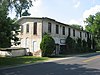
1
Aigler Alumni Building
February 12, 1979 (#79002779 ) 315 E. Market St. 41°06′58″N 83°10′10″W / 41.116111°N 83.169444°W / 41.116111; -83.169444 (Aigler Alumni Building ) Tiffin
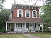
2
Bagby-Hossler House
July 10, 1986 (#86001562 ) 530 Sycamore St. 41°05′51″N 83°11′15″W / 41.097500°N 83.187500°W / 41.097500; -83.187500 (Bagby-Hossler House ) Tiffin
3
January 7, 1980 (#80003217 ) 4th Ave. and Vine St. 41°07′51″N 83°10′59″W / 41.130833°N 83.183056°W / 41.130833; -83.183056 (Beatty Glass Company ) Tiffin
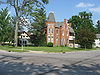
4
Black Student Union Center
February 12, 1979 (#79002780 ) 120 Hedges St. 41°06′50″N 83°10′02″W / 41.113889°N 83.167222°W / 41.113889; -83.167222 (Black Student Union Center ) Tiffin
5
January 7, 1980 (#80003218 ) 215 Riverside Dr. 41°07′20″N 83°10′18″W / 41.122222°N 83.171667°W / 41.122222; -83.171667 (Bowman's Distillery ) Tiffin
6
February 12, 1979 (#79002778 ) 310 E. Market St. 41°06′59″N 83°10′04″W / 41.116389°N 83.167778°W / 41.116389; -83.167778 (College Hall ) Tiffin
7
June 20, 1979 (#79001942 ) 957 N. Union St. 41°10′08″N 83°25′09″W / 41.168889°N 83.419167°W / 41.168889; -83.419167 (Ambrose Cory House ) Fostoria
8
January 23, 2003 (#02001730 ) 652 N. Sandusky St. 41°08′04″N 83°10′06″W / 41.134444°N 83.168333°W / 41.134444; -83.168333 (Daughters of America National Home ) Tiffin
9
May 2, 1978 (#78002186 ) Roughly bounded by Riverside Dr., Jefferson, S. Washington St., E. Market, Madison, and Court Sts. 41°06′46″N 83°10′33″W / 41.112778°N 83.175833°W / 41.112778; -83.175833 (Downtown Tiffin Historic District ) Tiffin
10
June 20, 1979 (#79001944 ) Roughly bounded by the Sandusky River and Perry, Sandusky and Washington Sts. 41°07′02″N 83°11′02″W / 41.117222°N 83.183889°W / 41.117222; -83.183889 (Fort Ball-Railroad Historic District ) Tiffin
11
September 28, 2001 (#01001065 ) Roughly bounded by North St., South St., and the alleys east and west of Main St. 41°09′23″N 83°24′52″W / 41.156389°N 83.414444°W / 41.156389; -83.414444 (Fostoria Downtown Historic District ) Fostoria
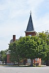
12
March 20, 1973 (#73001534 ) Perry St. (State Route 18 ) 41°06′59″N 83°10′02″W / 41.116389°N 83.167222°W / 41.116389; -83.167222 (Founders Hall, Heidelberg College ) Tiffin
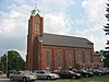
13
February 12, 1979 (#79002776 ) 119 Greenfield St. 41°06′55″N 83°09′52″W / 41.115278°N 83.164444°W / 41.115278; -83.164444 (France Hall ) Tiffin
14
February 12, 1979 (#79002766 ) 285 E. Perry St. 41°07′00″N 83°10′06″W / 41.116667°N 83.168333°W / 41.116667; -83.168333 (Gerhart-Rust Residence ) Tiffin
15
February 12, 1979 (#79002777 ) 44 Greenfield St. 41°06′53″N 83°10′06″W / 41.114778°N 83.168333°W / 41.114778; -83.168333 (Great Hall ) Tiffin
16
January 7, 1980 (#80003219 ) 235 Miami St. 41°07′11″N 83°11′16″W / 41.119722°N 83.187778°W / 41.119722; -83.187778 (Hanson Machinery Company ) Tiffin
17
January 7, 1980 (#80003220 ) 255 Riverside Dr. 41°07′25″N 83°10′14″W / 41.123611°N 83.170556°W / 41.123611; -83.170556 (Hedges-Hunter-Keller-Bacon Gristmill ) Tiffin
18
November 6, 1979 (#79003646 ) Western half of the southwestern corner of section 1, on the northern side of County Road 34 east of the northwestern railroad tracks and east of Flat Rock 41°14′29″N 82°50′50″W / 41.241389°N 82.847222°W / 41.241389; -82.847222 (Henny Barn ) Thompson Township
19
March 29, 1979 (#79001941 ) 8531 N. County Road 29, southwest of Bellevue[6] 41°14′45″N 82°51′33″W / 41.245833°N 82.859167°W / 41.245833; -82.859167 (Heter Farm ) Thompson Township
20
January 7, 1980 (#80003221 ) 260 Riverside Dr. 41°07′23″N 83°10′12″W / 41.123056°N 83.17°W / 41.123056; -83.17 (William Hunter House ) Tiffin
21
October 1, 1990 (#90001499 ) 600 N. River Rd. 41°07′55″N 83°09′33″W / 41.131944°N 83.159167°W / 41.131944; -83.159167 (Junior Order United American Mechanics National Orphans' Home ) Tiffin
22
February 12, 1979 (#79002775 ) 70 Greenfield St. 41°06′54″N 83°09′59″W / 41.115°N 83.166389°W / 41.115; -83.166389 (Laird Hall ) Tiffin
23
March 21, 1979 (#79001945 ) 155 Miami St. 41°07′06″N 83°11′04″W / 41.118333°N 83.184444°W / 41.118333; -83.184444 (Miami Street Grade School ) Tiffin
24
Michaels Farm
November 29, 1979 (#79001943 ) South of Kansas on State Route 635 41°13′43″N 83°16′46″W / 41.228611°N 83.279444°W / 41.228611; -83.279444 (Michaels Farm ) Liberty Township
25
January 7, 1980 (#80003222 ) 146-164 Riverside Dr. 41°07′11″N 83°10′21″W / 41.119722°N 83.1725°W / 41.119722; -83.1725 (Mueller Brewery ) Tiffin
26
January 7, 1980 (#80003223 ) 140-142 Riverside Dr. 41°07′11″N 83°10′22″W / 41.119722°N 83.172778°W / 41.119722; -83.172778 (Christ Mueller House ) Tiffin
27
May 27, 1980 (#80003224 ) N. Sandusky St. 41°07′23″N 83°10′49″W / 41.123056°N 83.180278°W / 41.123056; -83.180278 (North Sandusky Street Historic District ) Tiffin
28
May 28, 1980 (#80003225 ) Clinton, Ohio, and Hunter Sts. 41°07′12″N 83°10′09″W / 41.12°N 83.169167°W / 41.12; -83.169167 (Northeast Tiffin Historic District ) Tiffin
29
The Octagon
February 12, 1979 (#79002764 ) 297 E. Perry St. 41°07′00″N 83°10′05″W / 41.116667°N 83.168056°W / 41.116667; -83.168056 (The Octagon ) Tiffin
30
January 7, 1980 (#80003226 ) 60-72 Hudson St. 41°07′13″N 83°10′47″W / 41.120278°N 83.179722°W / 41.120278; -83.179722 (Ohio Lantern Company ) Tiffin
31
Omar Chapel
November 5, 1987 (#87001982 ) 408 State Route 4 , north of Attica 41°07′06″N 82°51′46″W / 41.118333°N 82.862778°W / 41.118333; -82.862778 (Omar Chapel ) Reed Township
32
February 12, 1979 (#79002773 ) 28 Greenfield St. 41°06′55″N 83°10′05″W / 41.115278°N 83.168056°W / 41.115278; -83.168056 (Pfleiderer Center for Religion and the Humanities ) Tiffin
33
Pleasant Ridge United Methodist Church and Cemetery
September 10, 1993 (#93000880 ) Junction of State Route 101 and County Road 38, northeast of Tiffin 41°10′05″N 83°05′58″W / 41.168056°N 83.099444°W / 41.168056; -83.099444 (Pleasant Ridge United Methodist Church and Cemetery ) Pleasant Township
34
February 12, 1979 (#79002768 ) 67 Greenfield St. 41°06′56″N 83°09′59″W / 41.115556°N 83.166389°W / 41.115556; -83.166389 (President's House ) Tiffin
35
St. Boniface Roman Catholic Church, School, Rectory, and Convent of the Sisters of the Precious Blood
November 17, 1982 (#82001487 ) N. Perry St. 41°03′16″N 83°19′17″W / 41.054333°N 83.321333°W / 41.054333; -83.321333 (St. Boniface Roman Catholic Church, School, Rectory, and Convent of the Sisters of the Precious Blood ) New Riegel
36
February 12, 1979 (#79002782 ) 266 E. Market St. 41°06′55″N 83°10′12″W / 41.115333°N 83.170111°W / 41.115333; -83.170111 (Social Science House ) Tiffin
37
August 26, 1993 (#93000878 ) 318 Sycamore St. 41°06′09″N 83°10′56″W / 41.102500°N 83.182222°W / 41.102500; -83.182222 (Springdale ) Tiffin
38
January 7, 1980 (#80003227 ) 40 Harrison St. 41°07′13″N 83°10′32″W / 41.120278°N 83.175556°W / 41.120278; -83.175556 (Tiffin Agricultural Works ) Tiffin
39
January 7, 1980 (#80003228 ) 450 Wall St. 41°07′39″N 83°11′14″W / 41.127500°N 83.187222°W / 41.127500; -83.187222 (Tiffin Art Metal Company ) Tiffin
40
January 7, 1980 (#80003229 ) 170 Ella St. 41°06′16″N 83°11′14″W / 41.104444°N 83.187222°W / 41.104444; -83.187222 (Tiffin Waterworks ) Tiffin
41
April 27, 1979 (#79001946 ) North of Tiffin on County Road 38 41°10′05″N 83°09′37″W / 41.168056°N 83.160278°W / 41.168056; -83.160278 (Umsted Farm ) Pleasant Township
42
January 7, 1980 (#80003230 ) 250-258 Benner St. 41°06′52″N 83°11′04″W / 41.114583°N 83.184444°W / 41.114583; -83.184444 (Wagner Brothers Bottling Works ) Tiffin
43
January 7, 1980 (#80003231 ) 325 Hall St. 41°07′26″N 83°11′24″W / 41.123889°N 83.190000°W / 41.123889; -83.190000 (Webster Manufacturing ) Tiffin
44
February 12, 1979 (#79002771 ) 116 Greenfield St. 41°06′52″N 83°09′52″W / 41.114444°N 83.164444°W / 41.114444; -83.164444 (Williard Hall ) Tiffin