[3] Name on the Register[4]
Image
Date listed[5]
Location
City or town
Description
1
Charles Andres House Upload image November 6, 1995 (#95001196 ) County Road 154 (Fox Rd.) on Middle Bass Island 41°41′08″N 82°48′39″W / 41.6856°N 82.8108°W / 41.6856; -82.8108 (Charles Andres House ) Put-in-Bay Township
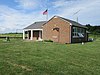
2
March 9, 1990 (#90000385 ) Toussaint E. Rd. and Behlman Rd., north of Oak Harbor 41°34′02″N 83°07′31″W / 41.5672°N 83.1253°W / 41.5672; -83.1253 (Carroll Township Hall ) Carroll Township
3
May 5, 1983 (#83002019 ) 3845 Wine Celler Rd., east of Port Clinton 41°31′55″N 82°51′31″W / 41.5319°N 82.8586°W / 41.5319; -82.8586 (Catawba Island Wine Company ) Catawba Island Township
4
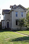
September 17, 1987 (#87001628 ) 133 Clemons St. 41°32′33″N 82°43′24″W / 41.5425°N 82.7233°W / 41.5425; -82.7233 (Alexander Clemons House ) Marblehead
5
Jay Cooke House
November 13, 1966 (#66000620 ) Gibraltar Island , Put-in-Bay, Lake Erie 41°39′29″N 82°49′16″W / 41.6581°N 82.8211°W / 41.6581; -82.8211 (Jay Cooke House ) Put-in-Bay
6
Upload image June 15, 1990 (#87000804 ) S. Shore Dr. on Middle Bass Island 41°41′40″N 82°47′13″W / 41.6944°N 82.7869°W / 41.6944; -82.7869 (East Point Manor ) Put-in-Bay Township
7
First Congregational Church
September 22, 2000 (#00001161 ) 802 Prairie St. 41°32′32″N 82°44′05″W / 41.5422°N 82.7347°W / 41.5422; -82.7347 (First Congregational Church ) Marblehead
8
March 19, 1992 (#92000175 ) Langrum Rd. on South Bass Island 41°38′43″N 82°49′13″W / 41.6453°N 82.8203°W / 41.6453; -82.8203 (Foster-Gram House ) Put-in-Bay Township
9
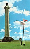
June 7, 1976 (#76001504 ) Main and 6th Sts. 41°31′05″N 83°21′29″W / 41.5181°N 83.3581°W / 41.5181; -83.3581 (Genoa Town Hall ) Genoa
10
July 16, 1992 (#92000888 ) 426 E. 4th St. 41°30′31″N 82°56′04″W / 41.5086°N 82.9344°W / 41.5086; -82.9344 (Gill-Luchsinger-Bahnsen House and Barn ) Port Clinton
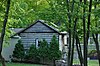
11
Upload image April 24, 1986 (#86000868 ) Fox and Lonz Rds. on Middle Bass Island 41°40′36″N 82°48′37″W / 41.6767°N 82.8103°W / 41.6767; -82.8103 (Golden Eagle Wine Cellars ) Put-in-Bay Township
12
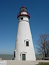
Green Island Light
December 18, 1990 (#90001909 ) Green Island in Lake Erie 41°38′44″N 82°51′57″W / 41.6456°N 82.8658°W / 41.6456; -82.8658 (Green Island Light ) Put-in-Bay Township ARLHS USA 353
13
December 12, 1976 (#76001506 ) Northeast of Put-in-Bay at the junction of Bayview Ave. and Chapman Rd. on South Bass Island 41°39′26″N 82°48′36″W / 41.6571°N 82.8100°W / 41.6571; -82.8100 (Inselruhe ) Put-in-Bay
14
July 2, 2008 (#08000623 ) 102 Madison St. 41°30′48″N 82°56′28″W / 41.5133°N 82.9411°W / 41.5133; -82.9411 (Island House ) Port Clinton
15
Johnson Island Civil War Prison and Fort Site
March 27, 1975 (#75001514 ) Eastern shore area of Johnson's Island 41°29′42″N 82°43′53″W / 41.4951°N 82.7313°W / 41.4951; -82.7313 (Johnson Island Civil War Prison and Fort Site ) Danbury Township
16
Lakeside Historic District
March 29, 1983 (#83002020 ) Roughly bounded by Lake Erie , railroad tracks, and Poplar and Oak Aves., in Lakeside 41°32′32″N 82°44′53″W / 41.5422°N 82.7481°W / 41.5422; -82.7481 (Lakeside Historic District ) Danbury Township Encompasses the entire gated community of Lakeside .
17
September 22, 1992 (#92001261 ) Roughly bounded by 8th, Washington, 5th, and West Sts. 41°31′07″N 83°21′30″W / 41.5186°N 83.3583°W / 41.5186; -83.3583 (Main Street Historic District ) Genoa
18
Marblehead Lighthouse
December 17, 1969 (#69000148 ) State Route 163 41°32′11″N 82°42′42″W / 41.5364°N 82.7117°W / 41.5364; -82.7117 (Marblehead Lighthouse ) Marblehead
19
Upload image August 23, 1985 (#85001843 ) Grape and Grove Aves. on Middle Bass Island 41°41′05″N 82°49′30″W / 41.6847°N 82.825°W / 41.6847; -82.825 (Middle Bass Club Historic District ) Put-in-Bay Township
20
May 6, 1976 (#76001505 ) About 4 mi (6.4 km) east of Port Clinton off State Route 53 41°31′55″N 82°51′29″W / 41.5319°N 82.8581°W / 41.5319; -82.8581 (Betsy Mo-John Cabin ) Catawba Island Township
21
June 22, 2020 (#100005289 ) 515 Kenny Rd. () 41°42′59″N 82°48′55″W / 41.7164°N 82.8154°W / 41.7164; -82.8154 (North Bass School ) Isle St. George , Put-in-Bay Township
22
March 17, 1994 (#94000239 ) State Route 51 over the Portage River 41°28′37″N 83°17′44″W / 41.4769°N 83.2956°W / 41.4769; -83.2956 (Ohio State Route 51 Bridge over the Portage River ) Elmore and Harris Township
23
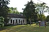
Old School Privy
July 31, 1975 (#75001515 ) 310 Main St. 41°30′54″N 83°21′34″W / 41.5149°N 83.3594°W / 41.5149; -83.3594 (Old School Privy ) Genoa
24
May 3, 1974 (#74001588 ) W. 4th and Madison Sts. 41°30′35″N 82°56′25″W / 41.5097°N 82.9403°W / 41.5097; -82.9403 (Ottawa County Courthouse ) Port Clinton
25
Perry's Victory and International Peace Memorial
October 15, 1966 (#66000118 ) South Bass Island 41°39′15″N 82°48′41″W / 41.6542°N 82.8114°W / 41.6542; -82.8114 (Perry's Victory and International Peace Memorial ) Put-in-Bay
26
February 10, 2000 (#00000096 ) Adams St. 41°30′44″N 82°56′16″W / 41.5122°N 82.9378°W / 41.5122; -82.9378 (Port Clinton City Hall ) Port Clinton
27
St. Thomas Episcopal Church
July 15, 1999 (#99000845 ) 214 E. 2nd St. 41°30′41″N 82°56′20″W / 41.5114°N 82.9389°W / 41.5114; -82.9389 (St. Thomas Episcopal Church ) Port Clinton
28
South Bass Island Light
April 5, 1990 (#90000473 ) Langram Rd., on the southwestern point of South Bass Island 41°37′46″N 82°50′30″W / 41.6294°N 82.8417°W / 41.6294; -82.8417 (South Bass Island Light ) Put-in-Bay Township
29
Upload image March 8, 2021 (#100006196 ) 5258 East Porter St. 41°34′58″N 82°50′06″W / 41.5827°N 82.8351°W / 41.5827; -82.8351 (Union Chapel ) Catawba Island Township
30
February 23, 1972 (#72001038 ) East Bay Shore Rd., 1 mi (1.6 km) west of its junction with Township Road 142 41°30′51″N 82°44′43″W / 41.5142°N 82.7453°W / 41.5142; -82.7453 (War Of 1812 Battle Site ) Danbury Township
31
Benajah Wolcott House
March 14, 1991 (#91000251 ) 9999 E. Bay Shore Rd., southwest of Marblehead 41°30′52″N 82°44′54″W / 41.5144°N 82.7483°W / 41.5144; -82.7483 (Benajah Wolcott House ) Danbury Township