[3] Name on the Register[4]
Image
Date listed[5]
Location
City or town
Description
1
African Jackson Cemetery
December 16, 1982 (#82001475 ) North of Piqua on Zimmerlin Rd. 40°09′25″N 84°14′07″W / 40.156944°N 84.235278°W / 40.156944; -84.235278 (African Jackson Cemetery ) Springcreek Township
2
Arrowston
February 8, 1980 (#80003162 ) 1220 Park Ave. 40°09′14″N 84°15′34″W / 40.153889°N 84.259444°W / 40.153889; -84.259444 (Arrowston ) Piqua
3
William Baumgardner House and Farm Buildings
February 17, 1978 (#78002141 ) 8390 National Rd., southwest of New Carlisle 39°54′22″N 84°03′35″W / 39.906111°N 84.059722°W / 39.906111; -84.059722 (William Baumgardner House and Farm Buildings ) Bethel Township
4
April 20, 1995 (#95000497 ) 501 E. Main St. 40°07′52″N 84°25′29″W / 40.131111°N 84.424722°W / 40.131111; -84.424722 (Bradford Junction Interlocking Tower ) Bradford
5
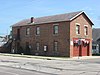
Casstown Lutheran Stone Church
May 31, 1984 (#84003783 ) 11 S. Main St. 40°03′05″N 84°07′46″W / 40.051306°N 84.129583°W / 40.051306; -84.129583 (Casstown Lutheran Stone Church ) Casstown
6
June 22, 1981 (#81000447 ) Spring and Pearl Sts. 40°06′59″N 84°21′12″W / 40.116389°N 84.353333°W / 40.116389; -84.353333 (Covington Historic Government Building ) Covington
7
October 10, 1975 (#75001489 ) 304 E. Franklin St. 40°02′13″N 84°12′05″W / 40.036944°N 84.201389°W / 40.036944; -84.201389 (Robert Culbertson House ) Troy
8
April 15, 2010 (#10000193 ) 128 W. Broadway 39°57′33″N 84°10′25″W / 39.959083°N 84.173722°W / 39.959083; -84.173722 (Detrick Milling and Distilling Company ) Tipp City
9
December 12, 1976 (#76001492 ) 16 E. Franklin St. 40°02′17″N 84°12′13″W / 40.038056°N 84.203611°W / 40.038056; -84.203611 (William K. Dunlap House ) Troy
10
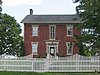
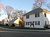
John Minor Dye Stone House
July 7, 1983 (#83002008 ) 9 S. Children's Home Rd., east of Troy 40°01′49″N 84°08′06″W / 40.030278°N 84.135°W / 40.030278; -84.135 (John Minor Dye Stone House ) Elizabeth Township
11
Eldean Covered Bridge
February 20, 1975 (#75001492 ) North of Troy across the Great Miami River on County Road 33 40°04′40″N 84°13′00″W / 40.077778°N 84.216667°W / 40.077778; -84.216667 (Eldean Covered Bridge ) Concord and Staunton Townships
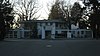
12
March 1, 1997 (#97000160 ) Roughly bounded by Lost Creek, the Miami and Clark County line, and Casstown Clark County and Elizabeth Bethel Rds. 40°00′45″N 84°05′53″W / 40.0125°N 84.098056°W / 40.0125; -84.098056 (Elizabeth Township Rural Historic District ) Elizabeth Township
13
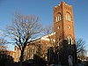
First Presbyterian Church
December 12, 1976 (#76001493 ) Franklin and Walnut Sts. 40°02′17″N 84°12′11″W / 40.038056°N 84.203056°W / 40.038056; -84.203056 (First Presbyterian Church ) Troy
14
Fort Piqua Hotel
February 15, 1974 (#74001576 ) 114 W. Main St. 40°08′56″N 84°14′24″W / 40.148889°N 84.240000°W / 40.148889; -84.240000 (Fort Piqua Hotel ) Piqua
15
January 30, 1976 (#76001494 ) 301 W. Main St. 40°02′26″N 84°12′22″W / 40.040556°N 84.206111°W / 40.040556; -84.206111 (Mary Jane Hayner House ) Troy
16
May 25, 1989 (#89000419 ) 2-9 Hobart Cir. and 11 and 23 Hobart Dr. 40°02′31″N 84°12′35″W / 40.041944°N 84.209722°W / 40.041944; -84.209722 (Hobart Circle Historic District ) Troy
17
May 25, 1989 (#89000420 ) 172 S. Ridge Ave. 40°02′35″N 84°13′12″W / 40.043056°N 84.22°W / 40.043056; -84.22 (E.A. Hobart House ) Troy
18
May 25, 1989 (#89000421 ) 905 Polecat Rd., north of Troy 40°04′35″N 84°11′24″W / 40.076333°N 84.19°W / 40.076333; -84.19 (William Hobart Vacation House ) Staunton Township
19
May 25, 1989 (#89000425 ) 121 S. Ridge Ave. 40°02′41″N 84°13′03″W / 40.044722°N 84.2175°W / 40.044722; -84.2175 (House at 121 South Ridge ) Troy
20
May 25, 1989 (#89000423 ) 129 S. Ridge Ave. 40°02′39″N 84°13′03″W / 40.044167°N 84.2175°W / 40.044167; -84.2175 (House at 129 South Ridge ) Troy
21
May 25, 1989 (#89000426 ) 145 S. Ridge Ave. 40°02′37″N 84°13′03″W / 40.043611°N 84.2175°W / 40.043611; -84.2175 (House at 145 South Ridge ) Troy
22
May 25, 1989 (#89000422 ) 203 Penn Rd. 40°02′33″N 84°12′56″W / 40.0425°N 84.215556°W / 40.0425; -84.215556 (House at 203 Penn Road ) Troy
23
May 25, 1989 (#89000424 ) 1022 W. Main St. 40°02′42″N 84°13′02″W / 40.045°N 84.217222°W / 40.045; -84.217222 (House at 1022 West Main Street ) Troy
24
November 21, 1976 (#76001497 ) 6.5 mi (10.5 km) west of Troy 40°00′58″N 84°19′05″W / 40.016000°N 84.318056°W / 40.016000; -84.318056 (Benjamin Iddings Log House ) Newton Township
25
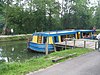
Lockington Locks Historical Area
December 17, 1969 (#69000147 ) Miami and Erie Canal between Lockington and Washington Township40°11′22″N 84°14′31″W / 40.189361°N 84.241875°W / 40.189361; -84.241875 (Lockington Locks Historical Area ) Washington Township Extends into Lockington and Washington Township in Shelby County
26
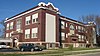
April 22, 2005 (#05000025 ) 240 S. Main St. 39°57′35″N 84°19′39″W / 39.959722°N 84.327500°W / 39.959722; -84.327500 (McKinley School ) West Milton
27
Miami County Courthouse and Power Station
May 30, 1975 (#75001490 ) Bounded by Main, Short, Plum, and Water Sts. 40°02′27″N 84°12′18″W / 40.040833°N 84.205°W / 40.040833; -84.205 (Miami County Courthouse and Power Station ) Troy
28
July 3, 2012 (#12000395 ) 4045 State Route 721 , south of Bradford 40°05′40″N 84°25′46″W / 40.094583°N 84.429583°W / 40.094583; -84.429583 (Newberry Township School ) Newberry Township
29
July 7, 1983 (#83002009 ) 5-439 W. Main St. and 3-225 E. Main St. 39°57′40″N 84°10′02″W / 39.961111°N 84.167222°W / 39.961111; -84.167222 (Old Tippecanoe Main Street Historic District ) Tipp City
30
Overfield Tavern
January 30, 1976 (#76001495 ) 201 E. Water St. 40°02′23″N 84°12′02″W / 40.039722°N 84.200556°W / 40.039722; -84.200556 (Overfield Tavern ) Troy One of Ohio's oldest taverns, built in 1808. Now a museum.
31
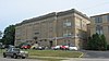
Piqua High School
August 22, 1996 (#96000927 ) 316 N. College St. 40°08′56″N 84°14′57″W / 40.148889°N 84.249167°W / 40.148889; -84.249167 (Piqua High School ) Piqua Built in 1914, converted to 78 senior housing units in 1995
32
April 7, 1971 (#71000646 ) State Route 66 , 1 mi (1.6 km) north of Piqua40°10′45″N 84°15′21″W / 40.179167°N 84.255833°W / 40.179167; -84.255833 (Piqua Historical Area State Memorial ) Washington Township
33
January 11, 1985 (#85000069 ) N. Main, Wayne, Downing, Caldwell Sts; W. Ash to Camp Sts. 40°08′59″N 84°14′22″W / 40.149722°N 84.239444°W / 40.149722; -84.239444 (Piqua-Caldwell Historic District ) Piqua
34
April 18, 1985 (#85000857 ) 535-545 Weddle Rd., southeast of Casstown 40°02′08″N 84°05′30″W / 40.035556°N 84.091667°W / 40.035556; -84.091667 (Plainview Farm ) Elizabeth Township
35
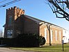
Pleasant Hill United Church of Christ
August 22, 2002 (#02000881 ) 10 W. Monument St. 40°03′07″N 84°20′43″W / 40.051944°N 84.345278°W / 40.051944; -84.345278 (Pleasant Hill United Church of Christ ) Pleasant Hill
36
August 12, 1986 (#86002620 ) McFarland St., north of Piqua 40°09′23″N 84°14′12″W / 40.156389°N 84.236667°W / 40.156389; -84.236667 (York Rial House ) Springcreek Township
37
November 21, 1976 (#76001491 ) 4525 McCandless Rd., southeast of Casstown 40°02′16″N 84°07′18″W / 40.037778°N 84.121667°W / 40.037778; -84.121667 (Elizabeth Sheets Saunders Farm ) Elizabeth Township
38
April 13, 2010 (#10000194 ) 101 W. Broadway 40°02′16″N 84°07′18″W / 40.037778°N 84.121667°W / 40.037778; -84.121667 (Saunders Seed Company ) Tipp City
39
February 1, 1988 (#87002522 ) 6880 LaFevre Rd. 40°01′34″N 84°04′36″W / 40.026111°N 84.076667°W / 40.026111; -84.076667 (Andrew Sheets House ) Elizabeth Township
40
March 24, 1980 (#80003161 ) North of Brandt at 7095 Staley Rd. 39°58′01″N 84°04′42″W / 39.966944°N 84.078333°W / 39.966944; -84.078333 (Staley Farm ) Bethel Township
41
Troy Public Square
June 30, 1975 (#75001491 ) Property surrounding the junction of Main and Market Sts. 40°02′22″N 84°12′12″W / 40.039444°N 84.203333°W / 40.039444; -84.203333 (Troy Public Square ) Troy
42
July 17, 1978 (#78002142 ) North of Troy at County Road 25A 40°05′18″N 84°13′24″W / 40.088333°N 84.223333°W / 40.088333; -84.223333 (Twin Arch Stone Culvert ) Concord Township
43
June 18, 1987 (#87000986 ) 5710 LeFevre Rd., east of Troy 40°01′32″N 84°05′59″W / 40.025556°N 84.099722°W / 40.025556; -84.099722 (Callahill and Priscilla Weddle House ) Elizabeth Township
44
January 1, 1976 (#76001496 ) 16 S. Cherry St. 40°02′22″N 84°12′17″W / 40.039444°N 84.204722°W / 40.039444; -84.204722 (Judge Henry Williams House ) Troy
45
December 15, 2015 (#15000903 ) 101 S. Wayne St. 40°08′47″N 84°14′26″W / 40.146389°N 84.240556°W / 40.146389; -84.240556 (S. Zollinger Company Building ) Piqua