Province of Lower Silesia
This article needs additional citations for verification. (January 2008) |
| Province of Lower Silesia Provinz Niederschlesien (German) | |||||||||||||||||
|---|---|---|---|---|---|---|---|---|---|---|---|---|---|---|---|---|---|
| Province of Prussia | |||||||||||||||||
| 1919–1938 1941–1945 | |||||||||||||||||
 Flag
 Coat of arms
| |||||||||||||||||
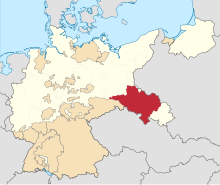 Province of Lower Silesia (red) within the Free State of Prussia. | |||||||||||||||||
| Capital | Breslau (now Wrocław) | ||||||||||||||||
| Area | |||||||||||||||||
• 1925 | 26,616 km2 (10,276 sq mi) | ||||||||||||||||
| Population | |||||||||||||||||
• 1925 | 3,132,135 | ||||||||||||||||
| History | |||||||||||||||||
• Established | 1919 | ||||||||||||||||
• Merged into Silesia Province | 1938–1941 | ||||||||||||||||
• Disestablished | 1945 | ||||||||||||||||
| |||||||||||||||||
| Today part of | |||||||||||||||||
The Province of Lower Silesia (German: Provinz Niederschlesien; Silesian German: Provinz Niederschläsing; Polish: Prowincja Dolny Śląsk; Silesian: Prowincyjŏ Dolny Ślōnsk) was a province of the Free State of Prussia from 1919 to 1945. Between 1938 and 1941 it was reunited with Upper Silesia as the Province of Silesia. The capital of Lower Silesia was Breslau (now Wrocław in Poland). The province was further divided into two administrative regions (Regierungsbezirke), Breslau and Liegnitz.[1]
The province was not congruent with the historical region of Lower Silesia, which now lies mainly in Poland. It additionally comprised the Upper Lusatian districts of Görlitz, Rothenburg and Hoyerswerda in the west, that until 1815 had belonged to the Kingdom of Saxony, as well as the former County of Kladsko in the southeast.
The province was disestablished at the end of World War II and with the implementation of the Oder–Neisse line in 1945, the area east of the Neisse river fell to the Republic of Poland. The smaller western part was incorporated into the German states of Saxony and Brandenburg.
Administrative regions[2][]
Regierungsbezirk Breslau[]
Urban districts / Stadtkreise[]
- City of Breslau
- City of Brieg
- City of Schweidnitz
- City of Waldenburg
Rural districts / Landkreise[]
- Landkreis Groß Wartenberg
- Landkreis Namslau
- Landkreis Neumarkt
- Landkreis Oels
- Landkreis Ohlau
Regierungsbezirk Liegnitz[]


Urban districts / Stadtkreise[]
- City of Glogau
- City of Görlitz
- City of Hirschberg im Riesengebirge
- City of Liegnitz
Rural districts / Landkreise[]
Post-1945 population[]
During the Polish post-war census of December 1950, data about the pre-war places of residence of the inhabitants as of August 1939 was collected. In case of children born between September 1939 and December 1950, their origin was reported based on the pre-war places of residence of their mothers. Thanks to this data it is possible to reconstruct the pre-war geographical origin of the post-war population. The same area corresponding to pre-1938 Province of Lower Silesia east of the Oder-Neisse line (which became Polish in 1945) was inhabited in December 1950 by:
| Region (within 1939 borders): | Number | Percent |
|---|---|---|
| Autochthons (1939 DE/FCD citizens) | 120,885 | 6,1% |
| Polish expellees from Kresy (USSR) | 696,739 | 35,3% |
| Poles from abroad except the USSR | 91,395 | 4,6% |
| Resettlers from the City of Warsaw | 61,862 | 3,1% |
| From Warsaw region (Masovia) | 69,120 | 3,5% |
| From Białystok region and Sudovia | 23,515 | 1,2% |
| From pre-war Polish Pomerania | 54,564 | 2,8% |
| Resettlers from Poznań region | 172,163 | 8,7% |
| Katowice region (East Upper Silesia) | 66,362 | 3,4% |
| Resettlers from the City of Łódź | 16,483 | 0,8% |
| Resettlers from Łódź region | 96,185 | 4,9% |
| Resettlers from Kielce region | 141,748 | 7,2% |
| Resettlers from Lublin region | 70,622 | 3,6% |
| Resettlers from Kraków region | 156,920 | 7,9% |
| Resettlers from Rzeszów region | 110,188 | 5,6% |
| place of residence in 1939 unknown | 26,586 | 1,3% |
| Total pop. in December 1950 | 1,975,337 | 100,0% |
Over 90% of the 1950 inhabitants were new to the region, with less than 10% residing in the province already back in August 1939 (so called autochthons, who had German citizenship before World War II and were granted Polish citizenship after 1945). The largest group among new inhabitants were Poles expelled from areas of Eastern Poland annexed by the USSR. The second largest group came from Southern Poland (from Kraków, Rzeszów, Lublin, Kielce and Katowice regions in total 28%) followed by Greater Poland. Many Poles from Bosnia settled around Bolesławiec.
See also[]
- Lower Silesian Voivodeship
- Niederschlesischer Oberlausitzkreis
- Territorial Association of Silesia
References[]
- ^ Division of Siliesia Province
- ^ Administrative divisions of Lower and Upper Silesia (in German)
- ^ Kosiński, Leszek (1960). "Pochodzenie terytorialne ludności Ziem Zachodnich w 1950 r. [Territorial origins of inhabitants of the Western Lands in year 1950]" (PDF). Dokumentacja Geograficzna (in Polish). Warsaw: PAN (Polish Academy of Sciences), Institute of Geography. 2: Tabela 1 (data by county) – via Repozytorium Cyfrowe Instytutów Naukowych.
| show Silesia topics |
|---|
| Authority control |
|---|
- States and territories established in 1919
- States and territories disestablished in 1945
- Province of Lower Silesia
- History of Silesia
- Provinces of Prussia
- 1919 establishments in Germany
- 1945 disestablishments in Germany
- Former eastern territories of Germany