Saint-Cyr-la-Rivière
Saint-Cyr-la-Rivière | |
|---|---|
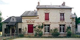 The school and town hall in Saint-Cyr-la-Rivière | |
 Coat of arms | |
show Location of Saint-Cyr-la-Rivière | |
 Saint-Cyr-la-Rivière | |
| Coordinates: 48°21′17″N 2°08′53″E / 48.3547°N 2.1481°ECoordinates: 48°21′17″N 2°08′53″E / 48.3547°N 2.1481°E | |
| Country | France |
| Region | Île-de-France |
| Department | Essonne |
| Arrondissement | Étampes |
| Canton | Étampes |
| Government | |
| • Mayor (2020–2026) | Christèle Deloison[1] |
| Area 1 | 8.81 km2 (3.40 sq mi) |
| Population (Jan. 2018)[2] | 517 |
| • Density | 59/km2 (150/sq mi) |
| Time zone | UTC+01:00 (CET) |
| • Summer (DST) | UTC+02:00 (CEST) |
| INSEE/Postal code | 91544 /91690 |
| Elevation | 72–146 m (236–479 ft) |
| 1 French Land Register data, which excludes lakes, ponds, glaciers > 1 km2 (0.386 sq mi or 247 acres) and river estuaries. | |


Saint-Cyr-la-Rivière is a commune in the Essonne department in Île-de-France in northern France.
Inhabitants of Saint-Cyr-la-Rivière are known as Saint-Cyriens.
Geography[]
The village lies on the left bank of the Éclimont, which forms the commune's northeastern border and flows into the Juine, which flows northeast through the northwestern part of the commune.
See also[]
References[]
- ^ "Répertoire national des élus: les maires". data.gouv.fr, Plateforme ouverte des données publiques françaises (in French). 2 December 2020.
- ^ "Populations légales 2018". INSEE. 28 December 2020.
External links[]
| Wikimedia Commons has media related to Saint-Cyr-la-Rivière. |
- Base Mérimée: Search for heritage in the commune, Ministère français de la Culture. (in French)
- Mayors of Essonne Association (in French)
| show Authority control |
|---|
This Essonne geographical article is a stub. You can help Wikipedia by . |
Categories:
- Communes of Essonne
- Essonne geography stubs