Villiers-sur-Orge
Villiers-sur-Orge | |
|---|---|
 The town hall in Villiers-sur-Orge | |
 Coat of arms | |
show Location of Villiers-sur-Orge | |
 Villiers-sur-Orge | |
| Coordinates: 48°39′27″N 2°18′00″E / 48.6574°N 2.3001°ECoordinates: 48°39′27″N 2°18′00″E / 48.6574°N 2.3001°E | |
| Country | France |
| Region | Île-de-France |
| Department | Essonne |
| Arrondissement | Palaiseau |
| Canton | Sainte-Geneviève-des-Bois |
| Intercommunality | CA Cœur d'Essonne |
| Government | |
| • Mayor (2020–2026) | Gilles Fraysse[1] |
| Area 1 | 1.78 km2 (0.69 sq mi) |
| Population (Jan. 2018)[2] | 4,592 |
| • Density | 2,600/km2 (6,700/sq mi) |
| Time zone | UTC+01:00 (CET) |
| • Summer (DST) | UTC+02:00 (CEST) |
| INSEE/Postal code | 91685 /91700 |
| Elevation | 37–89 m (121–292 ft) |
| 1 French Land Register data, which excludes lakes, ponds, glaciers > 1 km2 (0.386 sq mi or 247 acres) and river estuaries. | |


Villiers-sur-Orge is a commune in the arrondissement of Palaiseau, in the Essonne department, in the Île-de-France region.
Inhabitants of Villiers-sur-Orge are known as Villiérains.
Sites of interest[]
- Town hall
- Saint-Claude chapel
Location and transport[]
As the name suggests Villiers-sur-Orge is situated on the bank of the small river Orge. The Orge separates Villiers-sur-Orge from neighbouring Sainte-Geneviève-des-Bois.
Villiers-sur-Orge is located in the southern suburbs (banlieue) of Paris, France and can be accessed by car from the Francilienne ring road and the A6 motorway (part of the Autoroute du Soleil). The nearest train station is in neighbouring Sainte-Geneviève-des-Bois (RER line C).
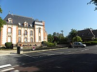
Town Hall
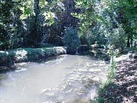
The Orge


See also[]
References[]
- ^ "Répertoire national des élus: les maires". data.gouv.fr, Plateforme ouverte des données publiques françaises (in French). 2 December 2020.
- ^ "Populations légales 2018". INSEE. 28 December 2020.
External links[]
| Wikimedia Commons has media related to Villiers-sur-Orge. |
- Official website (in French)
- Mayors of Essonne Association (in French)
| show Authority control |
|---|
This Essonne geographical article is a stub. You can help Wikipedia by . |
Categories:
- Communes of Essonne
- Essonne geography stubs