Saint-Paul, Oise
From Wikipedia, the free encyclopedia
Commune in Hauts-de-France, France
Saint-Paul | |
|---|---|
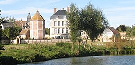 The abbey and church in Saint-Paul | |
 Coat of arms | |
 Saint-Paul  Saint-Paul | |
Coordinates:  49°25′48″N 2°00′28″E / 49.43°N 2.0078°E / 49.43; 2.0078Coordinates: 49°25′48″N 2°00′28″E / 49.43°N 2.0078°E / 49.43; 2.0078 49°25′48″N 2°00′28″E / 49.43°N 2.0078°E / 49.43; 2.0078Coordinates: 49°25′48″N 2°00′28″E / 49.43°N 2.0078°E / 49.43; 2.0078 | |
| Country | France |
| Region | Hauts-de-France |
| Department | Oise |
| Arrondissement | Beauvais |
| Canton | Beauvais-2 |
| Intercommunality | CA Beauvaisis |
| Government | |
| • Mayor (2020–2026) | Gérard Hédin[1] |
| Area 1 | 9.52 km2 (3.68 sq mi) |
| Population (Jan. 2018)[2] | 1,562 |
| • Density | 160/km2 (420/sq mi) |
| Time zone | UTC+01:00 (CET) |
| • Summer (DST) | UTC+02:00 (CEST) |
| INSEE/Postal code | 60591 /60650 |
| Elevation | 72–147 m (236–482 ft) (avg. 75 m or 246 ft) |
| 1 French Land Register data, which excludes lakes, ponds, glaciers > 1 km2 (0.386 sq mi or 247 acres) and river estuaries. | |

Saint-Paul is a commune in the Oise department in northern France.
See also[]
References[]
- ^ "Répertoire national des élus: les maires". data.gouv.fr, Plateforme ouverte des données publiques françaises (in French). 2 December 2020.
- ^ "Populations légales 2018". INSEE. 28 December 2020.
| Wikimedia Commons has media related to Saint-Paul (Oise). |
show
| |
|---|---|
| Prefecture |
|
| Subprefectures |
|
| Other |
|
This Oise geographical article is a stub. You can help Wikipedia by . |
- v
- t
Retrieved from ""
Categories:
- Communes of Oise
- Oise geography stubs
Hidden categories:
- CS1 French-language sources (fr)
- Articles with short description
- Short description is different from Wikidata
- Infobox mapframe without OSM relation ID on Wikidata
- Coordinates on Wikidata
- Pages using infobox settlement with image map1 but not image map
- Commons category link is on Wikidata
- Articles with BNF identifiers
- All stub articles
- Pages using the Kartographer extension