Salem Downtown Historic District (Salem, Ohio)
This article lacks inline citations besides NRIS, a database which provides minimal and sometimes ambiguous information. (November 2013) |
Salem Downtown Historic District | |
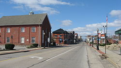
 Looking westward on E. State Street (State Route 14) on the eastern edge of downtown Salem, Ohio | |
 | |
| Location | Roughly bounded by Vine Ave., Ohio Ave., E. Pershing St., S. Ellsworth Ave. and Sugar Tree Alley, Salem, Ohio |
|---|---|
| Coordinates | 40°38′38″N 80°34′23″W / 40.643889°N 80.573056°WCoordinates: 40°38′38″N 80°34′23″W / 40.643889°N 80.573056°W |
| Area | 95 acres (38 ha) |
| Architect | Hutton, Finley; Owsley, Charles |
| Architectural style | Greek Revival, Italianate, Queen Anne |
| NRHP reference No. | 95001416[1] |
| Added to NRHP | December 7, 1995 |
The Salem Downtown Historic District is located in Salem, Ohio. The district covers approximately 95 acres (38 ha) bounded by Vine, Ohio, East Pershing, and South Ellsworth Streets, as well as Sugar Tree Alley. The district was added to the National Register of Historic Places in December 1995.
References[]
Categories:
- National Register of Historic Places in Columbiana County, Ohio
- Greek Revival architecture in Ohio
- Italianate architecture in Ohio
- Queen Anne architecture in Ohio
- Historic districts in Columbiana County, Ohio
- Historic districts on the National Register of Historic Places in Ohio
- Northeastern Ohio Registered Historic Place stubs


