Serayu River
| Serayu River Kali Serayu, Sungai Serayu, Ci Sarayu, Kali Seraju, Kali Serajoe, Chi Seraju, Serdju, Serajoe River | |
|---|---|
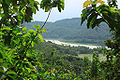
 Serayu river at Kebasen, Banyumas | |
 Location of river mouth | |
| Location | |
| Country | Central Java, Indonesia |
| Physical characteristics | |
| Source | |
| • location | Dieng Volcanic Complex |
| • elevation | 2,100 m (6,900 ft) asl |
| Mouth | |
• location | Indian Ocean |
| Length | 181 km (112 mi) |
| Basin size | 4,375 km2 (1,689 sq mi) |
| Discharge | |
| • average | 2,866 m3/s (101,200 cu ft/s) |

Serayu River is a river in Central Java, Indonesia, about 300 km southeast of the capital Jakarta.[1][2]
Hydrology[]
The river spanned from northeast to southwest with length around 181 km, and crossring five kabupaten (regency) in Central Java; they are Wonosobo Regency, Banjarnegara Regency, Purbalingga Regency, Banyumas Regency, draining to Indian Ocean with estuarine located at Cilacap Regency.[3]
Geography[]
The river flows in the southern central area of Java with predominantly tropical monsoon climate (designated as Am in the Köppen-Geiger climate classification).[4] The annual average temperature in the area is 24 °C. The warmest month is March, when the average temperature is around 25 °C, and the coldest is August, at 23 °C.[5] The average annual rainfall is 3897 mm. The wettest month is January, with an average of 561 mm rainfall, and the driest is September, with 34 mm rainfall.[6]
Uses[]
Mrica Dam is a hydroelectric powerplant dams are installed in Serayu River.[7][8]
Water rafting is one of the tourist attraction in the villages of Tunggara and Prigi, in Banjarnegara Regency.[9]
Gallery[]
Serayu river

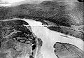
Railroad construction by the Serayu near Kebasen, Banyumas
Railroad bridge across Serayu near Kebasen
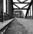
Bridge at Rawalo, Banyumas

Bridge near Maos, Cilacap (before 1917)

Bridge built in 1890
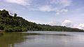
Serayu river


See also[]
- Sarayu River, in India, Sarayu and Serayu have been named after river in Hindu epic Ramayana
- Sunda Kingdom, Hindu kingdom of Central and Western Java through which this river flowed
- List of rivers of Indonesia
- List of rivers of Java
References[]
- ^ Kali Serayu at Geonames.org (cc-by); Last updated 2013-06-04; Database dump downloaded 2015-11-27
- ^ Rand McNally, The New International Atlas, 1993.
- ^ Munir, A. 2009. Karakteristik daerah aliran sungai (DAS) Serayu Provinsi Jawa Tengah berdasarkan kondisi fisik, sosial, serta ekonomi. Dept. Geografi FMIPA Universitas Indonesia. (paper tidak diterbitkan)
- ^ Peel, M C; Finlayson, B L; McMahon, T A (2007). "Updated world map of the Köppen-Geiger climate classification". Hydrology and Earth System Sciences. 11 (5): 1633–1644. doi:10.5194/hess-11-1633-2007. Retrieved 30 January 2016.
- ^ "NASA Earth Observations Data Set Index". NASA. 30 January 2016.
- ^ "NASA Earth Observations: Rainfall (1 month - TRMM)". NASA/Tropical Rainfall Monitoring Mission. 30 January 2016.
- ^ Tempo.co: Usia Waduk Mrica Diperkirakan Tinggal 12 Tahun. Diakses 5/XII/2014.
- ^ Dinas Budpar Banjarnegara: Wisata Waduk Mrica. Diakses 5/XII/2014.
- ^ Kab. Banjarnegara: Arung Jeram Kaliserayu. Diakses 5/XII/2014.
Coordinates: 7°41′17″S 109°06′02″E / 7.68806°S 109.10056°E

- Rivers of Central Java
- Rivers of Indonesia