Batang Hari River
| Batang Hari River Batang Hari, Sungai Batanghari, Djambi-rivier | |
|---|---|
 The Batang Hari photographed during the 1877-79 Sumatra Expedition | |
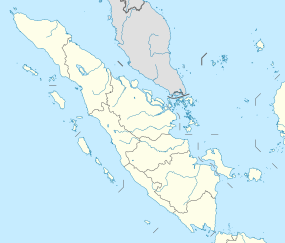 Location of river mouth | |
| Location | |
| Country | Indonesia |
| Province | West Sumatra, Jambi |
| Regency | Solok, Solok Selatan, Dharmasraya, Bungo, Tebo, Batang Hari, Muaro Jambi, Tanjung Jabung, Jambi City |
| Physical characteristics | |
| Source | Mount Rasan |
| • location | Solok Regency, West Sumatra |
| Mouth | Malacca Strait |
• location | East Tanjung Jabung Regency, Jambi |

The Batang Hari (Sungai Batanghari) is the longest river in Jambi province, Sumatra island,[1] Indonesia, about 600 km northwest of the capital Jakarta.[2]
Hydrology[]
It originates in the Minangkabau Highlands, home of the Minangkabau people, and flows to the east coast of Sumatra. Trans-Sumatran Highway (AH25) crosses the river at the city of Jambi which is located near the mouth of the river. The river is used by the local population for fish cultivation, transportation, mining, and personal hygiene.[3]
Geography[]
The river flows in the central area of Sumatra with predominantly tropical rainforest climate (designated as Af in the Köppen-Geiger climate classification).[4] The annual average temperature in the area is 23 °C. The warmest month is April, when the average temperature is around 24 °C, and the coldest is January, at 22 °C.[5] The average annual rainfall is 2383 mm. The wettest month is December, with an average of 344 mm rainfall, and the driest is August, with 90 mm rainfall.[6]
See also[]
References[]
- ^ "Reviving Batanghari's heyday". thejakartapost.com. Retrieved 2 August 2014.
- ^ Sungai Batang Hari at Geonames.org (cc-by); Last updated 2013-06-04; Database dump downloaded 2015-11-27
- ^ "Uses of the Batanghari River". Sumatran Feet. 2011-06-13. Retrieved 2018-04-23.
- ^ Peel, M C; Finlayson, B L; McMahon, T A (2007). "Updated world map of the Köppen-Geiger climate classification". Hydrology and Earth System Sciences. 11: 1633–1644. doi:10.5194/hess-11-1633-2007. Retrieved 30 January 2016.
- ^ "NASA Earth Observations Data Set Index". NASA. 30 January 2016.
- ^ "NASA Earth Observations: Rainfall (1 month - TRMM)". NASA/Tropical Rainfall Monitoring Mission. 30 January 2016.
External links[]
![]() Media related to Batang Hari River at Wikimedia Commons
Media related to Batang Hari River at Wikimedia Commons
Coordinates: 1°03′43″S 104°12′25″E / 1.06194°S 104.20694°E

- Rivers of Jambi
- Rivers of West Sumatra
- Rivers of Indonesia