Progo River
| Progo River Sungai Progo, Kali Progo, Kali Prage, Kali Praga, Praga River | |
|---|---|
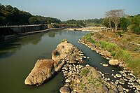 Progo River in Yogyakarta | |
 Location of river mouth | |
| Location | |
| Country | Indonesia |
| Physical characteristics | |
| Source | |
| • location | Mount Sundoro, Central Java |
| Mouth | |
• location | Indian Ocean, Trisik Beach, Kulon Progo Regency, Yogyakarta, |


The Progo River (Javanese: Kali Praga, ꦏꦭꦶꦥꦿꦒ, Javanese pronunciation: ['kali 'prɔgɔ]) is a river in southern central Java, Indonesia.[1] The river passes through two provinces; Central Java and Yogyakarta Special Region. The source of the river is on the slopes of Mount Sindoro, Central Java.
Hydrology[]
The river runs to the southeast through the city of Magelang, then through the historical Kedu Plain passing near the well known Borobudur, Mendut, and Pawon temples. Reaching the province of Yogyakarta the river forms a natural boundary between Sleman Regency, Kulon Progo Regency and Bantul Regency. The mouth of the river is located at Trisik beach on the southern shore of Java facing Indian Ocean.
Geography[]
The river flows in the southwest area of Java with predominantly tropical monsoon climate (designated as Am in the Köppen-Geiger climate classification).[2] The annual average temperature in the area is 24 °C. The warmest month is January, when the average temperature is around 27 °C, and the coldest is July, at 23 °C.[3] The average annual rainfall is 2970 mm. The wettest month is January, with an average of 537 mm rainfall, and the driest is September, with 22 mm rainfall.[4]
See also[]
References[]
- ^ Rand McNally, The New International Atlas, 1993.
- ^ Peel, M C; Finlayson, B L; McMahon, T A (2007). "Updated world map of the Köppen-Geiger climate classification". Hydrology and Earth System Sciences. 11: 1633–1644. doi:10.5194/hess-11-1633-2007. Retrieved 30 January 2016.
- ^ "NASA Earth Observations Data Set Index". NASA. 30 January 2016.
- ^ "NASA Earth Observations: Rainfall (1 month - TRMM)". NASA/Tropical Rainfall Monitoring Mission. 30 January 2016.
| Authority control |
|
|---|

- Rivers of Central Java
- Rivers of Yogyakarta
- Rivers of Indonesia