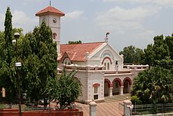
Yavatmal
This article needs additional citations for verification. (January 2012) |
Yavatmal | |
|---|---|
City | |
 Yavatmal Municipal Council | |
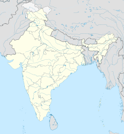
 Yavatmal Location in Maharashtra, India | |
| Coordinates: 20°14′N 78°04′E / 20.24°N 78.06°ECoordinates: 20°14′N 78°04′E / 20.24°N 78.06°E | |
| Country | |
| State | Maharashtra |
| Region | Vidarbha |
| District | Yavatmal |
| Government | |
| • Type | Municipality |
| • Body | Yavatmal Municipal Council |
| Area | |
| • City | 90 km2 (30 sq mi) |
| Area rank | 5 vidharbh |
| Elevation | 445 m (1,460 ft) |
| Population (2011)[1] | |
| • City | 270,551 |
| • Density | 3,000/km2 (7,800/sq mi) |
| • Metro | 300,000 |
| Languages | |
| • Official | Marathi |
| Time zone | UTC+5:30 (IST) |
| PIN | 445001-445002 |
| Telephone code | 07232 |
| Vehicle registration | MH-29 |
| Website | www |

Yavatmal (![]() pronunciation (help·info) is a city and municipal council in the Indian state of Maharashtra. It is the administrative headquarters of Yavatmal District. Yavatmal is around 90 km away from divisional headquarters Amravati while it is 670 km (420 mi) away from the state capital Mumbai. The name is derived from the Marathi Yavat (mountain) and mal (row).
pronunciation (help·info) is a city and municipal council in the Indian state of Maharashtra. It is the administrative headquarters of Yavatmal District. Yavatmal is around 90 km away from divisional headquarters Amravati while it is 670 km (420 mi) away from the state capital Mumbai. The name is derived from the Marathi Yavat (mountain) and mal (row).
History[]
This section does not cite any sources. (November 2019) |
Formerly known as "Yeoti" or "Yeotmal", Yavatmal was the main town of the Berar Sultanate and according to old writings "the dangerous place in the world". The then region of Yavatmal (now Yavatmal district), was part of the dominion of Aladdin Hassan Bahman Shah who founded the Bahmani Sultanate in 1347. In 1572, , ruler of the Ahmadnagar Sultanate (current day Ahmadnagar District), annexed the Yavatmal district. In 1596, Chand Bibi, warrior queen of Ahmadnagar, ceded the district of Yavatmal to the Mughal Empire, then rulers of a large part of India. Following the death of the sixth Mughal Emperor Aurangzeb in 1707, Yavatmal was passed on to the Maratha Empire. When Raghoji I Bhonsle became ruler of the Nagpur kingdom in 1783, he included the Yavatmal district in his territory. After the British East India Company created Berar Province in 1853, Yavatmal became part of East Berar District in 1863 and later part of the South East Berar district—both districts of the Central Provinces and Berar. Yavatmal remained part of Madhya Pradesh until the 1956 reorganization of states when it was transferred to the Bombay State. With the creation of the Maharashtra state on 1 May 1960, Yavatmal district became a part of the same.
Yavatmal Municipal Council was constituted in 1869 but was dissolved shortly thereafter. It was established again in 1894 and thus forms the oldest municipal council in the district. Mr. Eliot was first mayor and Lieutenant, W. Hege was deputy mayor. Govind Punaji Bari was the first Indian president of the Yavatmal Municipal council (02-Jan-1914 to 31 May 1932). The first elections conducted for the position of president of municipal council were held on 22 December 1934. Prior to that the same was appointed.[citation needed]
The mini-train called Shakuntala is a historic remark built by the British government to transport cotton which is now closed.
Demographics[]
As of 2011 Indian Census, Yavatmal had a total population of 116,551, of which 58,549 were males and 58,002 were females. The population within the age group of 0 to 6 years was 11,360. The total number of literates in Yavatmal was 96,726, which constituted 82.9% of the population with male literacy of 85.1% and female literacy of 80.9%. The effective literacy rate of 7+ population of Yavatmal was 91.9%, of which the male literacy rate was 94.8% and the female literacy rate was 89.1%. The Scheduled Castes and Scheduled Tribes population was 19,816 and 6,543 respectively. Yavatmal had 26173 households in 2011.[1]
Language[]
The principal language of the Yavatmal district is Marathi however Varhadi dialect of Marathi majorly spoken by people of Yavatmal. However, since the district has numerous Scheduled and Nomadic Tribes, other languages such as Gormati or Banjari, Gondi, Urdu, Telugu and Kolami are also spoken in parts of the district. In 1973, the Marathi Sahitya Sammelan (Marathi Literature Conference) was hosted in the city for the first time which was presided over by Gajanan Digambar Madgulkar. The second time, it was hosted on 11 January 2019 chaired by Vaishali Yende, widow of a suicide victim farmer, to highlight the issue of farmer suicides in the area.[citation needed]
Culture[]
This section does not cite any sources. (November 2019) |
Yavatmal is known for its unique Navratri festival celebration, the whole city is known for organizing huge celebration events for Navratri. Festivals like Gudi Padwa, Diwali, Dussehra, Bakar-Eid, Ramadan, Christmas, Easter Sunday and almost all Hindu, Muslim and Christian occasions are celebrated. The district is also home to a Buddhist community.
Climate[]
This city has a tropical climate. The Köppen-Geiger climate classification is Aw. In Yavatmal, the average annual temperature is 26.8 °C. The rainfall here averages 946 mm.
| hideClimate data for Yavatmal (1981–2010, extremes 1949–2011) | |||||||||||||
|---|---|---|---|---|---|---|---|---|---|---|---|---|---|
| Month | Jan | Feb | Mar | Apr | May | Jun | Jul | Aug | Sep | Oct | Nov | Dec | Year |
| Record high °C (°F) | 35.2 (95.4) |
38.8 (101.8) |
41.8 (107.2) |
45.4 (113.7) |
46.6 (115.9) |
46.6 (115.9) |
39.5 (103.1) |
35.8 (96.4) |
38.2 (100.8) |
37.4 (99.3) |
34.9 (94.8) |
34.0 (93.2) |
46.6 (115.9) |
| Average high °C (°F) | 28.6 (83.5) |
31.5 (88.7) |
36.0 (96.8) |
40.1 (104.2) |
41.4 (106.5) |
36.6 (97.9) |
30.5 (86.9) |
29.1 (84.4) |
30.8 (87.4) |
31.5 (88.7) |
29.8 (85.6) |
28.3 (82.9) |
32.8 (91.0) |
| Average low °C (°F) | 15.3 (59.5) |
17.3 (63.1) |
21.2 (70.2) |
24.8 (76.6) |
26.8 (80.2) |
24.7 (76.5) |
22.5 (72.5) |
22.0 (71.6) |
21.8 (71.2) |
19.9 (67.8) |
17.0 (62.6) |
14.6 (58.3) |
20.7 (69.3) |
| Record low °C (°F) | 6.4 (43.5) |
7.2 (45.0) |
9.8 (49.6) |
13.5 (56.3) |
18.2 (64.8) |
16.1 (61.0) |
15.2 (59.4) |
16.0 (60.8) |
13.2 (55.8) |
13.0 (55.4) |
8.6 (47.5) |
6.2 (43.2) |
6.2 (43.2) |
| Average rainfall mm (inches) | 19.2 (0.76) |
8.6 (0.34) |
12.8 (0.50) |
7.9 (0.31) |
18.6 (0.73) |
195.1 (7.68) |
280.0 (11.02) |
266.8 (10.50) |
146.4 (5.76) |
61.3 (2.41) |
14.6 (0.57) |
9.3 (0.37) |
1,040.5 (40.96) |
| Average rainy days | 1.2 | 1.1 | 1.2 | 0.9 | 1.5 | 8.9 | 13.6 | 11.6 | 8.0 | 3.4 | 0.9 | 0.7 | 53.0 |
| Average relative humidity (%) (at 17:30 IST) | 37 | 29 | 22 | 19 | 22 | 47 | 70 | 75 | 67 | 53 | 43 | 39 | 44 |
| Source: India Meteorological Department[2][3] | |||||||||||||
Economy[]
This section does not cite any sources. (June 2017) |
During British rule, Yavatmal city was classified as a hill station. Both cotton-ginning and pressing are carried on in Yavatmal, while the town is also the chief trading center in the district and connected by road with Dhamangaon station, 29 miles (47 km) away. Major business establishments in Yavatmal include the Raymonds factory which produces special fiber for jeans. There are establishments related to the cotton, and textile industries. There is a 106-acre (0.43 km2) textile Special Economic Zone (SEZ) under construction while HLL Unilever has also decided to restart the plant they currently have in the city. Other local businesses in the town are dominated by the presence of agricultural supply facilities used by the nearby farming community.
Banking services are available in the Yavatmal, Arni, Ner, Pusad, Digras, Ghatanji and Pandharkawada and Wani areas.
The major industrial centres are at: MIDC Lohara, Darwha, Digras, Pusad, Umerkhed, Wani, Umari, Pandharkawada, Ralegaon and Babhulgaon, Ner, and Wani-Maregaon with the main market places in: Yavatmal City, Arni, Wani, Darwha, Digras, Ghatanji, Mohada, Pusad, Umerkhed and Pandharkawada.
Transport[]
Roads[]
- The National Highway NH 44 (Varanasi–Kanyakumari) passes through the district at Vadki, Karanji, Pandharkawada, Patanbori, and Kelapur.[4]
- New National Highway is been proposed Dharni-Amravati-Yavatmal-Karanji on NH 44.
- The state highway (Amravati–Chandrapur) passes through Ner, Yavatmal, Jodmoha, Mohada, Umari, Karanja and Wani .
- The (Nagpur–Tuljapur) National highway 361 passes through Kalamb, Yavatmal, Arni, and Umarkhed.
- Mumbai–Nagpur Expressway will indirectly connect to Yavatmal City with Feeder roads.
Railways[]
- Yavatmal is the southern terminus of the 762 mm (30.0 in) narrow gauge railway known locally as the Shakuntala Railway. This line is composed of two legs intersecting with the 5 ft 6 in (1,676 mm) broad gauge Howrah-Nagpur-Mumbai line at Murtijapur – the 76 km (47 mi) northern leg to Achalpur and the 113 km (70 mi) southeastern leg to Yavatmal.[5] Darwha Station lies on this line.
Another line, passes through the district. Wani is a railway station on this line.[4] The state cabinet has approved Wardha–Nanded rail link project. This railway line will connect Wardha–Yavatmal in Vidarbha with Nanded in Marathwada. India's First will run From Nagpur to Yavatmal on Nagpur-Wardha,Wardha-Yavatmal-Nanded line.
Airport[]
- Yavatmal airport is located 9 km (5.6 mi) east of the city of Yavatmal and has been taken up by Reliance Airport Developers Ltd for development.[6]
Education[]
Prominent educational institutes:
- Shri Vasantrao Naik Government Medical College[7]
- Technical: Government College of Engineering, Government Polytechnic,[8] Government Residential Women's Polytechnic,[9] Jawaharlal Darda Engineering and Technical Institute[10] (private), Jagdamba College of Engineering,[11]
- Other: Amolakchand Mahavidyalaya (Science, Arts and Commerce),[12] Babaji Datey Kala & Vanijya Mahavidyalaya, Yavatmal (Arts and Commerce College),[13]
Notable people[]
- Vijay Darda, former MP (Rajya Sabha), Chairman Lokmat media Pvt. Ltd
- Jambuwantrao Dhote, politician and founder of Vidarbha Janata Congress
- Nachiket Mor, banker and National Director for Bill and Melinda Gates Foundation.
- Sudhakarrao Naik,former Chief Minister of Maharashtra.
- Vasantrao Naik, former Chief Minister of Maharashtra.
- Sanjay Rathod,former Guardian minister Yavatmal
- Manikrao Thakre, former President Maharashtra State Congress Committee
- Madan Madhukarrao Yerawar, former Guardian minister Yavatmal
See also[]
- Rani Amravati
- Make in Maharashtra
References[]
- ^ Jump up to: a b "Census of India: Yavatmal". www.censusindia.gov.in. Retrieved 25 October 2019.
- ^ "Station: Yeotmal Climatological Table 1981–2010" (PDF). Climatological Normals 1981–2010. India Meteorological Department. January 2015. pp. 799–800. Archived from the original (PDF) on 5 February 2020. Retrieved 3 April 2020.
- ^ "Extremes of Temperature & Rainfall for Indian Stations (Up to 2012)" (PDF). India Meteorological Department. December 2016. p. M155. Archived from the original (PDF) on 5 February 2020. Retrieved 3 April 2020.
- ^ Jump up to: a b "Transports, Trades & Commerce". Yavatmal district information. Retrieved 1 April 2012.
- ^ "Indian Narrow-Gauge Lines 2002–2003". Simon Mortimer, Indian Railways Fan Club. 13 February 2004.
- ^ "Reliance Airport gets five projects on lease". The Times of India. 6 August 2009. Archived from the original on 27 September 2012. Retrieved 19 September 2011.
- ^ "Shri Vasantrao Naik Government Medical College". vngmcytl.org. Retrieved 11 March 2018.
- ^ "Government Polytechnic Yavatmal". gpyavatmal.edu.in. Retrieved 11 March 2018.
- ^ "Government Residential Women's Polytechnic". grwpy.ac.in. Retrieved 11 March 2018.
- ^ "Jawaharlal Darda Engineering and Technical Institute". jdiet.ac.in. Retrieved 11 March 2018.
- ^ "Jagdamba College of Engineering". jcoet.org. Retrieved 11 March 2018.
- ^ "Amolakchand Vidhi Mahavidyalaya". amolakchandmahavidyalaya.org/. Retrieved 11 March 2018.
- ^ "Babaji Datey Kala ani Vanijya Mahavidyalaya". dateycollege.in. Retrieved 11 March 2018.
External links[]
| show Places adjacent to Yavatmal |
|---|
| hide Major villages of Yavatmal district | |
|---|---|
|
| show Authority control |
|---|
- Cities and towns in Yavatmal district
- Talukas in Maharashtra
- Cities in Maharashtra
- Yavatmal