Éhein
Éhein
Éhin (Walloon) | |
|---|---|
 Éhein Location in Belgium | |
| Coordinates: 50°32′N 05°26′E / 50.533°N 5.433°ECoordinates: 50°32′N 05°26′E / 50.533°N 5.433°E | |
| Country | Belgium |
| Community | French Community |
| Region | |
| Province | Liège |
| Arrondissement | Liège (Éhein-Haut) Huy (Éhein-Bas) |
| Postal codes | 4120 (Éhein-Haut) 4480 (Éhein-Bas) |
| Area codes | 04 |

Éhein (Walloon: Éhin) is a former municipality of Wallonia located in the province of Liège, Belgium.
As a result of the fusion of the Belgian municipalities in 1977, it was split in two: Éhein-Haut, the southern part, became part of Neupré, while Éhein-Bas, on the banks of the Meuse, was subsumed into Engis.
Caves[]
The rock has many caves, the best-known of which are the Lyell Cave and the . Early explorations of the caves were done by Philippe-Charles Schmerling starting in 1829. Subsequent researchers, including Ernest Doudou, have proven that the area was inhabited since the Paleolithic.[citation needed]
Gallery[]

Rocky spur of Engihoul, from the west. Left is the Meuse.

Rocky spur of Engihoul, from the east, starting at the quarry of Carmeuse.
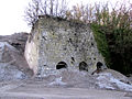
Ancient lime kiln at the foot of the spur (east side).


- Former municipalities of Liège (province)
- Neanderthal sites