Řikonín
Řikonín | |
|---|---|
Municipality | |
 | |
 Flag  Coat of arms | |
 Řikonín | |
| Coordinates: 49°21′46″N 16°18′20″E / 49.36278°N 16.30556°ECoordinates: 49°21′46″N 16°18′20″E / 49.36278°N 16.30556°E | |
| Country | |
| Region | South Moravian |
| District | Brno-Country |
| Area | |
| • Total | 2.61 km2 (1.01 sq mi) |
| Elevation | 355 m (1,165 ft) |
| Population (2006) | |
| • Total | 35 |
| • Density | 13/km2 (35/sq mi) |
| Postal code | 594 51 |

Řikonín is a village and municipality (obec) in Brno-Country District in the South Moravian Region of the Czech Republic.
The municipality covers an area of 2.61 square kilometres (1.01 sq mi), and has a population of 35 (as at 2 October 2006).
Řikonín lies approximately 29 kilometres (18 mi) north-west of Brno and 158 km (98 mi) south-east of Prague.
Gallery[]
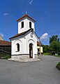
The Chapel
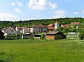
Overal view


References[]
| Wikimedia Commons has media related to Řikonín. |
This South Moravian Region location article is a stub. You can help Wikipedia by . |
Categories:
- Villages in Brno-Country District
- South Moravian Region geography stubs