Rudka (Brno-Country District)
Rudka | |
|---|---|
Municipality | |
 | |
 Flag  Coat of arms | |
 Rudka | |
| Coordinates: 49°14′26″N 16°19′54″E / 49.24056°N 16.33167°ECoordinates: 49°14′26″N 16°19′54″E / 49.24056°N 16.33167°E | |
| Country | |
| Region | South Moravian |
| District | Brno-Country |
| Area | |
| • Total | 4.14 km2 (1.60 sq mi) |
| Elevation | 445 m (1,460 ft) |
| Population (1.1.2012) | |
| • Total | 355 |
| • Density | 86/km2 (220/sq mi) |
| Postal code | 664 83 |
| Website | http://www.obecrudka.cz |

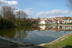
Rudka is a village and municipality (obec) in Brno-Country District in the South Moravian Region of the Czech Republic.
The municipality covers an area of 4.14 square kilometres (1.60 sq mi), and has a population of 352 (as at 3 July 2006).
Rudka lies approximately 22 kilometres (14 mi) west of Brno and 167 km (104 mi) south-east of Prague.
References[]
| Wikimedia Commons has media related to Rudka (Brno-Country District). |
| Authority control: National libraries |
|---|
This South Moravian Region location article is a stub. You can help Wikipedia by . |
Categories:
- Villages in Brno-Country District
- South Moravian Region geography stubs