Tetčice
Tetčice | |
|---|---|
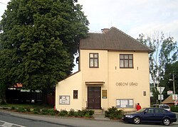 Municipal office | |
 Flag  Coat of arms | |
 Tetčice Location in the Czech Republic | |
| Coordinates: 49°10′13″N 16°24′20″E / 49.17028°N 16.40556°ECoordinates: 49°10′13″N 16°24′20″E / 49.17028°N 16.40556°E | |
| Country | |
| Region | South Moravian |
| District | Brno-Country |
| First mentioned | 1240 |
| Area | |
| • Total | 15.12 km2 (5.84 sq mi) |
| Elevation | 326 m (1,070 ft) |
| Population (2020-01-01[1]) | |
| • Total | 1,167 |
| • Density | 77/km2 (200/sq mi) |
| Time zone | UTC+1 (CET) |
| • Summer (DST) | UTC+2 (CEST) |
| Postal code | 664 17 |
| Website | tetcice |

Tetčice is a municipality and village in Brno-Country District in the South Moravian Region of the Czech Republic. It has about 1,200 inhabitants.
Tetčice lies approximately 16 kilometres (10 mi) west of Brno and 177 km (110 mi) south-east of Prague.
History[]
The first written mention of Tetčice is from 1240.[2]
References[]
- ^ "Population of Municipalities – 1 January 2020". Czech Statistical Office. 2020-04-30.
- ^ "Historie obce" (in Czech). Obec Tetčice. Retrieved 2020-11-27.
| Wikimedia Commons has media related to Tetčice. |
| Authority control: National libraries |
|---|
This South Moravian Region location article is a stub. You can help Wikipedia by . |
Categories:
- Villages in Brno-Country District
- South Moravian Region geography stubs