2014 Pacific typhoon season
| 2014 Pacific typhoon season | |
|---|---|
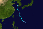
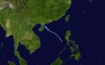
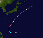
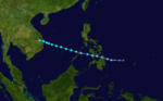
 Season summary map | |
| Seasonal boundaries | |
| First system formed | January 10, 2014 |
| Last system dissipated | January 1, 2015 |
| Strongest storm | |
| Name | Vongfong |
| • Maximum winds | 215 km/h (130 mph) (10-minute sustained) |
| • Lowest pressure | 900 hPa (mbar) |
| Seasonal statistics | |
| Total depressions | 32 |
| Total storms | 23 |
| Typhoons | 11 |
| Super typhoons | 8 (unofficial) |
| Total fatalities | 572 total |
| Total damage | $12.92 billion (2014 USD) |
| Related articles | |
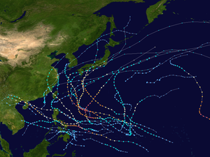
The 2014 Pacific typhoon season was a slightly below average season, featuring 23 tropical storms, 11 typhoons, 8 super typhoons, and 7 Category 5 typhoons. The season's peak months August and September saw minimal activity caused by an unusually strong and a persistent suppressing phase of the Madden–Julian oscillation (MJO). The season ran throughout 2014, though most tropical cyclones typically develop between May and October. The season began with the development of Tropical Storm Lingling on January 18, and ended after Tropical Storm Jangmi which dissipated on January 1 of the next year.
The season was not as active, deadly and costly as the previous typhoon season, but was notable for producing a series of powerful super typhoons. In fact, this season saw the most storms reaching Category 5 intensity on the Saffir–Simpson scale (seven–Neoguri, Rammasun, Halong, Genevieve, Vongfong, Nuri and Hagupit) since 1997. Two of those were notable; Rammasun became one of only three Category 5 typhoons recorded in the South China Sea with the others being Typhoon Pamela in 1954 and Meranti in 2016. The typhoon killed about 200 people and caused roughly US$8 billion worth of damage in China and the Philippines. Genevieve, a long-lasting system, was the first since 1999 for a system to exist in all three Northern Pacific basins.[1]
The scope of this article is limited to the Pacific Ocean to the north of the equator between 100°E and 180th meridian. Within the northwestern Pacific Ocean, there are two separate agencies that assign names to tropical cyclones which can often result in a cyclone having two names. The Japan Meteorological Agency (JMA) will name a tropical cyclone should it be judged to have 10-minute sustained wind speeds of at least 65 kilometres per hour (40 mph) anywhere in the basin, whilst the Philippine Atmospheric, Geophysical and Astronomical Services Administration (PAGASA) assigns names to tropical cyclones which move into or form as a tropical depression in their area of responsibility located between 135°E–115°E and between 5°N–25°N regardless of whether or not a tropical cyclone has already been given a name by the JMA. Tropical depressions that are monitored by the United States' Joint Typhoon Warning Center (JTWC) are given a number with a "W" suffix.
Seasonal forecasts[]
| TSR forecasts Date |
Tropical storms |
Total Typhoons |
Intense TCs |
ACE | Ref |
|---|---|---|---|---|---|
| Average (1965–2013) | 26 | 16 | 8 | 295 | [1] |
| May 6, 2014 | 27 | 17 | 11 | 375 | [1] |
| July 3, 2014 | 26 | 16 | 9 | 335 | [1] |
| August 5, 2014 | 26 | 16 | 9 | 328 | [1] |
| Other forecasts Date |
Forecast Center |
Period | Systems | Ref | |
| January 10, 2014 | PAGASA | January — March | 1–2 tropical cyclones | [2] | |
| January 10, 2014 | PAGASA | April — June | 3–6 tropical cyclones | [2] | |
| June 30, 2014 | CWB | January 1 — December 31 | 29–32 tropical storms | [3] | |
| July 7, 2014 | PAGASA | July — September | 8–10 tropical cyclones | [4] | |
| July 7, 2014 | PAGASA | October — December | 5–7 tropical cyclones | [4] | |
| Forecast Center |
Tropical cyclones |
Tropical storms |
Typhoons | Ref | |
| Actual activity: | JMA | 32 | 23 | 11 | [5] |
| Actual activity: | JTWC | 24 | 22 | 13 | [6] |
| Actual activity: | PAGASA | 19 | 16 | 9 | |
Every year several national meteorological services and scientific agencies forecast how many tropical cyclones, tropical storms, and typhoons will form during a season and/or how many tropical cyclones will affect a particular country.[1] These agencies include the Tropical Storm Risk (TSR) Consortium of the University College London, Philippine Atmospheric, Geophysical and Astronomical Services Administration (PAGASA) and the Taiwan's Central Weather Bureau.[1][2][3] During October 2013, the Vietnamese National Center for Hydro Meteorological Forecasts (VNCHMF) predicted that one to two tropical cyclones would develop and possibly affect Vietnam between November 2013 and April 2014.[7] Within its January — June seasonal climate outlook, PAGASA predicted that one to two tropical cyclones were likely to develop and/or enter the Philippine area of responsibility between January and March while three to six were predicted for the April to June period.[2] During March the Hong Kong Observatory predicted that the typhoon season in Hong Kong, would be near normal with four to seven tropical cyclones passing within 500 km (310 mi) of the territory compared to an average of 6.[8]
On May 5 and 6, China Meteorological Administration's Shanghai Typhoon Institute (CMA-STI) predicted that 26-28 tropical storms would develop over the basin, while Tropical Storm Risk issued their first forecast for the season and predicted an active typhoon season.[1] As a result 27 tropical storms, 17 typhoons and 11 intense typhoons were predicted to occur, while an ACE Index of 375 was also predicted by TSR.[1] In late June Taiwan's Central Weather Bureau predicted that 29-32 tropical storms would develop over the basin, while three-five systems were expected to affect Taiwan itself.[3] Within its July — December seasonal climate outlook, PAGASA predicted that eight to ten tropical cyclones were likely to develop and/or enter the Philippine area of responsibility between July and September, while five to seven were predicted for the October–December period.[4] Within its two final forecasts for 2014, Tropical Storm Risk predicted that 26 tropical storms, 16 typhoons and 9 intense typhoons would develop over the basin.[1]
Season summary[]

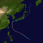
A total of 32 systems developed throughout 2014, of which 23 reached tropical storm strength. Of the eleven typhoons, eight peaked at Category 5-equivalent intensity. Although the season featured below-normal activity overall, the season's first half was unusually active[citation needed] with eight named storms developing. Two of those storms, Lingling and Kajiki, both affected the Philippines during January, which is the first time since 1986 where two systems have developed during the month of January. In July, tropical activity increased, with most of the storms developing that month strengthening into typhoons. Moreover, all storms that developed during that month impacted land and caused significant damage and many casualties. In August, Genevieve, from the Eastern and Central Pacific basins, entered the West Pacific basin. However, no other tropical cyclones exceeded tropical storm intensity that month. This was largely due to a very strong, but unfavorable phase of the Madden–Julian oscillation (MJO), which hindered tropical cyclone formation.[1]
Conditions for tropical cyclogenesis became more favorable during September with the formation of Tropical Depression Karding and Severe Tropical Storm Fengshen, although activity was still below-normal. During the same month, Kalmaegi and Fung-wong both impacted the Philippines, bringing torrential rainfall, causing flash flooding in many provinces. Typhoons Phanfone and Vongfong both became intense typhoons and affected Japan during October. Later that month, Typhoon Nuri developed and resulted in the formation of the 2014 Bering Sea bomb cyclone. Towards the end of the season, Typhoon Hagupit intensified into a Category 5-equivalent super typhoon before weakening and affecting the Philippines as a Category 3-equivalent typhoon. Hagupit caused much fewer impacts than Typhoon Haiyan of the previous year. The season's last named storm, Tropical Storm Jangmi, developed in December 28. Jangmi affected the southern Philippines and dissipated during January 1, 2015, making it the first storm in the Western Pacific to span two calendar years since Typhoon Soulik in 2000.[1]
Systems[]
Tropical Storm Lingling (Agaton)[]
| Tropical storm (JMA) | |
| Tropical depression (SSHWS) | |
  | |
| Duration | January 10 – January 20 |
|---|---|
| Peak intensity | 65 km/h (40 mph) (10-min) 1002 hPa (mbar) |
On January 10, the JMA reported that a tropical depression had developed, about 1,800 km (1,120 mi) to the southeast of Manila, Philippines.[9][10] The JMA expected the system to develop into a tropical storm within 24 hours, despite it being located in an area of marginal conditions for further development.[9][11] The JMA downgraded it back to a weak tropical disturbance on January 12, when convection became more disorganized.[12][13] Although its remnants crossed Mindanao, Philippines on January 13 and emerged into the area off the northeast coast of Mindanao on the next day.[14][15]
The system intensified into a tropical depression again on January 15 with the poor structure under high vertical wind shear and strong northeasterly surges, and the JTWC issued a TCFA on the system on the next day, for the consolidating structure and more favorable conditions.[16] On January 17, PAGASA upgraded the system to a tropical depression and gave the local name Agaton.[17] During the next day the JMA reported that the system had intensified into a tropical storm and named it Lingling.[16] Six hours later, the JTWC upgraded Lingling to a tropical storm, based on the scatterometer data and Dvorak estimates; though post-analysis revealed that the system never strengthened into a tropical storm by the JTWC.[18] Half a day later, however, the JTWC downgraded Lingling to a tropical depression, for significantly diminishing convection.[18] The system was last noted by the JMA, during January 20, as it dissipated to the southeast of the Philippines.[16]
Despite not making landfall as a tropical cyclone on the Philippines, the system brought considerable rainfall over several days to southern Mindanao that caused six flooding and sixteen landslide incidents.[19][20] As a result the majority of the 70 deaths caused by the system in the Philippines, were as a result of landslides or people drowning.[19][20] Other impacts caused by Lingling (Agaton) included damage to 3482 houses and flooding to the irrigation dams in Cateel, Davao Oriental.[20] Overall the total cost of damages was estimated at PHP567 million (US$12.6 million).[19][20]
Tropical Storm Kajiki (Basyang)[]
| Tropical storm (JMA) | |
| Tropical storm (SSHWS) | |
  | |
| Duration | January 29 – February 1 |
|---|---|
| Peak intensity | 65 km/h (40 mph) (10-min) 1000 hPa (mbar) |
On January 29, the JMA reported that a tropical depression had developed about 475 km (295 mi) to the south-southeast of Hagåtña, Guam.[21] Over the next day the system moved westwards within an area that was marginal for further development, with low to moderate vertical wind shear and moved into the Philippine area of responsibility.[19][21][22] As a result PAGASA named the system Basyang during January 30, while the JTWC initiated advisories and designated the system as Tropical Depression 02W.[19][23] The system subsequently continued to move westwards under the influence of the subtropical ridge of high pressure, before it reached its peak intensity as a tropical storm with wind speeds of 65 kilometres per hour (40 mph) during January 31.[19][23] According to PAGASA, the storm made landfall over Siargao Island on January 31.[24] Due to the unfavorable conditions in the South China Sea, Kajiki dissipated late on February 1.[25][26]
Kajiki impacted the Philippines between January 30 and February 1, where a total of 13 landslides and 4 flooding incidents, were recorded in the provinces of Cebu and Southern Leyte.[27] Overall six people were killed in the island nation while total damages were estimated at Php9.14 million (US$202,000).[27]
Typhoon Faxai[]
| Typhoon (JMA) | |
| Category 1 typhoon (SSHWS) | |
  | |
| Duration | February 27 – March 5 |
|---|---|
| Peak intensity | 120 km/h (75 mph) (10-min) 975 hPa (mbar) |
On February 27, the JMA started to monitor a tropical disturbance, that had developed, about 630 km (390 mi) to the south-southeast of Hagåtña, Guam.[28] During the following day, it was upgraded by the JTWC to a tropical depression, and designated as 03W.[29][30] Several hours later, the JMA upgraded the system to a tropical storm and named it Faxai.[31][32] Faxai began to rapidly intensify into a severe tropical storm, and then typhoon, for a short period of time on March 4.[33][34][35] The system transitioned into an extratropical cyclone during March 6, before it dissipated during March 8, while located around 800 km (495 mi) to the northeast of Wake Island.[28]
Despite passing well to the east of Guam, Faxai's wind and an enhanced wind flow to the north of the typhoon generated large swells, which claimed the life of a woman.[36]
Tropical Depression 04W (Caloy)[]
| Tropical depression (JMA) | |
| Tropical depression (SSHWS) | |
  | |
| Duration | March 17 – March 24 |
|---|---|
| Peak intensity | 35 km/h (25 mph) (10-min) 1004 hPa (mbar) |
On March 17, the JMA reported that a tropical depression had developed about 375 mi (605 km) to the east of Melekeok, Palau.[37] Over the next few days, the system became more organised and it was named Caloy by PAGASA on March 21.[38] During March 22, the JTWC started warning on the depression, giving the designation of 04W with winds of only 45 kilometres per hour (28 mph),[39] while in the same time, Caloy made landfall over in Mindanao. Though, the JTWC issued its final warning as the system started to deteriorate later that same day.[39] Caloy dissipated two days later as it emerged in the Sulu Sea.
Tropical Storm Peipah (Domeng)[]
| Tropical storm (JMA) | |
| Tropical storm (SSHWS) | |
  | |
| Duration | April 2 – April 15 |
|---|---|
| Peak intensity | 65 km/h (40 mph) (10-min) 998 hPa (mbar) |
On March 30, a cluster of thunderstorms formed near the equator and Papua New Guinea, where the large cluster separated into two systems, with the other strengthening into Cyclone Ita.[40] It intensified into a tropical depression on April 2[41] and strengthened into 05W by the JTWC the next day.[42] On April 4, convection built up and the system intensified into a tropical storm, prompting the JMA to name it Peipah.[41] Though during the next day, both agencies downgraded Peipah to a tropical depression, where the JTWC issued its final advisory.[41][42] By April 6, the system entered into the Philippine Area of Responsibility, and was named Domeng by PAGASA, however they also issued their final advisory few hours later.[43][44] The JMA continued to track the system until April 8 as it was located over eastern Philippines and had weakened into a low-pressure area.[41]
Late on April 13, the remnants of Peipah regenerated into a tropical depression to the east of the Philippines, while slowly continuing to approach the island nation.[45] On April 15, the depression became disorganized and the system's convection was displaced from its center of circulation, prompting the JTWC to issue its final advisory on the system.[46] During the next several hours, the remnants of the depression turned towards the southwest, until it dissipated late on April 15, just off the northeastern coast of the island of Mindanao.[46]
Severe Tropical Storm Tapah[]
| Severe tropical storm (JMA) | |
| Category 1 typhoon (SSHWS) | |
  | |
| Duration | April 27 – May 2 |
|---|---|
| Peak intensity | 95 km/h (60 mph) (10-min) 985 hPa (mbar) |
Early on April 27, the JMA reported that a tropical depression had formed about 420 km (260 mi) to the south-southeast of Hagåtña, Guam.[47] Later that day, the JTWC upgraded it to Tropical Depression 06W as it moved north.[48] Due to warm waters, the system rapidly intensified into a tropical storm with the JMA naming it Tapah on April 28.[49][50] Later that day, convection occurred and the system was upgraded to a severe tropical storm.[51] Early on April 29, the JTWC upgraded Tapah into a minimal typhoon.[52] It weakened back to a tropical storm during April 30.[47] During May 1, the system weakened into a tropical depression because of the effects of strong vertical windshear and a decrease in sea surface temperatures, before the JTWC issued their final advisory on the system.[47][53] The system was subsequently last noted by the JMA during the next day, as it dissipated over 1,300 km (810 mi) to the south-east of Tokyo, Japan.[47]
Tropical Storm Mitag (Ester)[]
| Tropical storm (JMA) | |
| Subtropical storm (SSHWS) | |
  | |
| Duration | June 9 – June 12 |
|---|---|
| Peak intensity | 75 km/h (45 mph) (10-min) 994 hPa (mbar) |
On June 9, the JMA reported that a tropical depression had developed about 115 km (71 mi) to the south-southeast of Hengchun, Taiwan.[54] During the net day, PAGASA named the system Ester, as it brought flooding to the Philippines.[55] By June 11, convection increased near the system's center as the JMA upgraded the system to a tropical storm, naming it Mitag.[54] The JTWC did not track the storm, however in their advisory, they have classified Mitag as "subtropical".[56] Mitag peaked with 10-minute sustained winds of 75 kilometres per hour (47 mph) later that day until it was last noted by the JMA early on June 12, as the system was absorbed by a developing extratropical cyclone located north of Japan.[54]
There was no damage reported in association with Tropical Storm Mitag (Ester) in the Philippines, however, it did prompt PAGASA to declare the official start of the rainy season on June 10, 2014.[19][57][58]
Tropical Storm Hagibis[]
| Tropical storm (JMA) | |
| Tropical storm (SSHWS) | |
  | |
| Duration | June 13 – June 18 |
|---|---|
| Peak intensity | 75 km/h (45 mph) (10-min) 996 hPa (mbar) |
Similar to the formation of Mitag, the JMA started to track a tropical depression over in the South China Sea on June 13.[59] Later that day, the JTWC upgraded the system to Tropical Depression 07W, and at the same time, the JMA upgraded it to a tropical storm, naming it Hagibis.[59][60] Early on June 15, Hagibis made landfall over southern China.[61] During the next day, both agencies stopped issuing warnings on the system, as it rapidly weakened to a tropical depression over land.[59][60] Its remnants still continued to move northward, qand on June 17, the remnants of Hagibis curved eastwards, as it re-generated into a tropical storm. As a result, both agencies re-initiated advisories on Hagibis.[59][60] Late on June 17, Hagibis transitioned into an extratropical cyclone.[60] The system moved out of the basin on June 23.[59] Hagibis made landfall over southern China at 04:50 UTC on June 15. Torrential rain continued to bring flooding until June 22, as the southwest monsoon weakened. No people were killed, and total economic losses in Mainland China were counted to be CNY 1.23 billion (US$198 million).[62]
Typhoon Neoguri (Florita)[]
| Typhoon (JMA) | |
| Category 5 super typhoon (SSHWS) | |
  | |
| Duration | July 2 – July 11 |
|---|---|
| Peak intensity | 185 km/h (115 mph) (10-min) 930 hPa (mbar) |
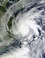
During July 2, the JMA started to track a tropical depression about 220 km (140 mi) east of Chuuk State.[63] The JTWC followed suit early on July 3, with the designation of 08W.[64] Early on July 4, it was upgraded to a tropical storm by the both agencies, with the latter naming it as Neoguri.[63][64] Later that day, Neoguri rapidly intensified into a Category 2 typhoon. By the next day, rapid intensification ensued and was upgraded to Category 4 typhoon status by the JTWC as an eye developed clearly.[64] At the same time, the storm entered the PAR, with PAGASA giving it the local name Florita.[65] Late the next day, Neoguri entered an area of very warm sea temperatures and intensified into a super typhoon. The storm reached peak intensity early on July 7, which the JTWC operationally assessed as 1-minute winds of 250 kilometres per hour (160 mph), with a minimum pressure of 930 hPa by the JMA,[66] though in post-analysis Neoguri reached Category 5 intensity.[63][64] Early on July 8, Neoguri weakened to a Category 3 typhoon and PAGASA stated that the storm had exited their area later that day.[67] Late the next day, Neoguri further weakened to a severe tropical storm by the JMA.[63] Due to the strong jet stream, Neoguri moved in an eastward direction instead of moving towards Korea. On July 10, JMA downgraded the system to a tropical storm and the JTWC issued its final advisory a few hours later as it started to become extratropical.[64] At the same time, Neoguri's circulation became totally exposed as it was affecting southern Japan.[68] The JMA made their final warning early on July 11, as Neoguri became extratropical. Its extratropical remnants of Neoguri collided with another weak, developing system north of it late on July 13.[63]
Throughout its path, Neoguri only caused three fatalities from Japan.[69] A total of 670,000 people were forced to evacuate and about 40 flights were canceled throughout the country where 580,000 of them in Okinawa Prefecture and 90,000 in Kyushu from the period of July 7–9.[70][71] Total damage in Japan were standing at ¥64 billion (US$632 million).[72] On July 12, a few days after the typhoon, a heat wave swept across parts of Honshu and Hokkaido, killing one person.[73]
Typhoon Rammasun (Glenda)[]
| Typhoon (JMA) | |
| Category 5 super typhoon (SSHWS) | |
  | |
| Duration | July 9 – July 20 |
|---|---|
| Peak intensity | 165 km/h (105 mph) (10-min) 935 hPa (mbar) |
On July 9, the JMA started to track a tropical depression roughly 280 km (175 mi) east of Chuuk State.[74] The JTWC followed suit a few hours later with the designation of 09W.[75] Subsequent convective deepening and enhancement of banding features resulted in the system's classification as a tropical storm on July 12 with the JMA assigning the name of Rammasun.[74][75] Acquiring a slight southerly component to its track, Rammasun gradually intensified over the following days.[citation needed] Owing to its proximity to the Philippines, PAGASA began monitoring the storm on July 13 and assigned it the local name Glenda.[76] The system achieved typhoon strength on July 14 after a 27 km (17 mi) wide eye formed.[74] Rapid intensification ensued on the next day as Rammasun struck the Bicol Region of the Philippines as a Category 4 typhoon with 1-minute winds of 215 kilometres per hour (134 mph).[75]
Turning back to the west-northwest, Rammasun weakened significantly as it traversed the Philippines.[74][75] The system emerged over the South China Sea on July 16 with its eye no longer visible on satellite imagery. After briefly weakening to a severe tropical storm, favorable environmental conditions allowed for reorganization and Rammasun reached its peak intensity on July 18 as it approached southern China with a minimum pressure of 935 hPa.[74] Featuring a well-defined eye surrounded by deep convection and prominent outflow, the JMA estimated the typhoon's winds at 165 kilometres per hour (103 mph). Similar to Neoguri, operationally, the JTWC considered the system with peak winds equivalent to a high-end of Category 4 typhoon status, though its post-analysis showed that Rammasun briefly intensified into a Category 5.[75] Weakening took place thereafter with the storm clipping Hainan Island and later striking Guangxi Province. Rammasun degraded to a tropical storm after moving ashore and ultimately dissipated on July 20 over Yunnan Province.[74][75]
As of July 17, it is reported from NDRRMC that the death toll has reached 40 and the total amount of damages were amounted to 1 billion pesos ($27 million USD).[77] In China, 18 persons were killed due to the storm.[78] Total damages amounted to US$8 billion. Rammasun killed over 200 people.
Typhoon Matmo (Henry)[]
| Typhoon (JMA) | |
| Category 2 typhoon (SSHWS) | |
  | |
| Duration | July 16 – July 25 |
|---|---|
| Peak intensity | 130 km/h (80 mph) (10-min) 965 hPa (mbar) |
On July 16, the JMA started to monitor a weak tropical depression to the northeast of Palau.[79] The JTWC followed suit early on the next day.[80] At the same day, the depression had intensified into a tropical storm, assigning the name Matmo.[79] Early on July 18, Matmo entered the PAR, with PAGASA giving it the name Henry.[81] By July 19, Matmo further intensified into a severe tropical storm while the JTWC had already considered it as a Category 1 typhoon as it started tracking northwestward.[79][80] Gradually intensifying, Matmo reached Category 2 typhoon intensity on July 21, and peak early on July 22 with 1-minute sustained winds of 165 kilometres per hour (103 mph).[80] Later that day, the storm made landfall over in Hualien City. Matmo rapidly weakened throughout most of the next day when it made its second landfall in China as a tropical storm; the JTWC issued their final advisory later that day.[80] The JTWC, however, tracked the system until July 25 when it became an extratropical system. Its remnants fully dissipated on July 26 near the Korean Peninsula.[79]
One person was reported dead and there was some damage reported.[82] At least 48 people died in a plane crash in the Taiwan strait; the crash may have been caused by the typhoon.[83] As of July 24, according to the Yilan County Government, the agricultural damage in the county was estimated at about NT$44 million ($1.5 million USD).[84]
Typhoon Halong (Jose)[]
| Typhoon (JMA) | |
| Category 5 super typhoon (SSHWS) | |
  | |
| Duration | July 27 – August 11 |
|---|---|
| Peak intensity | 195 km/h (120 mph) (10-min) 920 hPa (mbar) |
During July 27, the JMA started to track a tropical depression to the southeast of the Mariana Islands.[85] The JTWC followed suit early the next day, giving the designation of 11W.[86] Early on July 29, the system had intensified into Tropical Storm Halong.[85] After two days of steady organization, Halong started to intensify into a severe tropical storm. By August 1, both agencies upgraded the storm to a typhoon.[85][86] After a period of rapid deepening, Halong developed a clearer eye, and the JTWC further upgraded Halong to a Category 3, then to a Category 5 super typhoon. Halong peaked early on August 3 when it had sustained winds of 195 kilometres per hour (121 mph) and a pressure of 920 hPa.[85][86] At the same time, PAGASA had reported that Halong had entered their area of responsibility, and assigned the local name Jose.[87] On August 4, Halong underwent an eyewall replacement cycle and consequently, it weakened to a Category 4 typhoon as it curved northwards, and by August 5, Halong was further downgraded to a minimal typhoon.[86] Halong maintained that intensity until made landfall over to the east of Tokyo, Japan on August 9, where the typhoon weakened to a severe tropical storm. By August 10, the JTWC stopped warning on Halong as it was already considered as "extratropical".[86] The JMA tracked the system until early on August 11, though its remnants continued for over the next couple of days where the system had moved westwards into the Sea of Okhotsk, before it was last noted during August 15, as it moved into the Pacific Ocean.[85]
Severe Tropical Storm Nakri (Inday)[]
| Severe tropical storm (JMA) | |
| Tropical storm (SSHWS) | |
  | |
| Duration | July 28 – August 4 |
|---|---|
| Peak intensity | 100 km/h (65 mph) (10-min) 980 hPa (mbar) |
On July 28, the JMA and the PAGASA started to track a tropical depression well east of the Babuyan Islands, with PAGASA naming it as Inday.[88] Gradually intensifying, the JMA upgraded the system to Tropical Storm Nakri the next day. After passing through the Ryukyu Islands, on July 31, Nakri further deepened into a severe tropical storm.[88] The JTWC, although, had only classified this as a "monsoonal disturbance" with winds packing at 40 knots.[89] As Nakri neared the Korean Peninsula, the JTWC had begun warning on the system, although the JMA had already downgraded it to a tropical storm. Six hours later, the JTWC downgraded the system to a depression and stopped warning on Nakri.[89] The JMA continued tracking the system as a tropical depression until it dissipated on August 4.[88]
Despite Nakri did not cause direct impacts on the Philippines, the storm caused damages of Php5.13 million (US$118,000).[90] Over 3,500 hectares of farmland were flooded and uprooted about 130 trees over in South Korea and killed a total of ten people.[91] Damage in Haenam County reached ₩1.573 billion (US$1.52 million).[92] In Japan, Nakri brought flash flooding in many prefectures, especially when the city of Iwakuni broke its record for receiving the most amount of rainfall in 1 hour and 3 hours, with 2.79 inches and 6.14 inches, respectively. The city of Anan also received about 26 inches of rainfall, making it the wettest August since reliable records began in August 1978. Nakri also caused landslides, causing two deaths. An additional one person were killed.[93] Total loss from Nakri, along with Typhoon Halong, were up to ¥89 billion (US$870 million).[94]
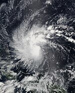
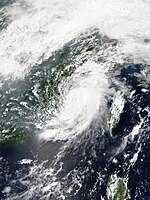
Typhoon Genevieve[]
| Typhoon (JMA) | |
| Category 5 super typhoon (SSHWS) | |
  | |
| Duration | August 7 (Entered basin) – August 14 |
|---|---|
| Peak intensity | 205 km/h (125 mph) (10-min) 915 hPa (mbar) |
On August 7, Hurricane Genevieve entered the West Pacific basin at Category 4 super typhoon status.[95] Later that day, the Joint Typhoon Warning Center (JTWC) upgraded the system to a Category 5 super typhoon.[96] Genevieve entered an area of favorable conditions and low vertical windshear, as it continued to intensify. Later on August 7, Genevieve reached its peak intensity, with winds of 110 knots (205 km/h; 125 mph), and with this, it became the third strongest storm within the Northwest Pacific in 2014.[97] On August 9, Genevieve started to move in a northward direction, towards low to moderate vertical windshear.[98] Later that day, the JTWC downgraded the system to a category 3 typhoon.[99] Later that day, Genevieve rapidly weakened to a strong Category 2 typhoon, as it began to encounter increasing windshear and drier inflow, to the south of the system. At the same time, the eye of the typhoon began to shrink.[100][101] On August 10, Genevieve weakened to a minimal typhoon, as it began to develop a secondary eye, but the secondary eye soon disappeared, due to the storm moving over cooler waters.[102] Both agencies downgraded the system to a severe tropical storm later that day, and rapidly weakening to a minimal tropical storm on August 11.[103] Later that day, Genevieve started to lose its identity, and showed a bit of subtropical characteristics. With this, JTWC issued their final advisory on the storm.[104] However, JMA tracked Genevieve until August 14, as it interacted with a high-pressure area. The remnant energy of Genevieve continued and was absorbed by a developing low-pressure area north of it on August 15.[105][106]
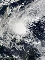
Severe Tropical Storm Fengshen[]
| Severe tropical storm (JMA) | |
| Category 1 typhoon (SSHWS) | |
  | |
| Duration | September 5 – September 10 |
|---|---|
| Peak intensity | 110 km/h (70 mph) (10-min) 975 hPa (mbar) |
After nearly a month of tropical inactivity, the JMA started to track a tropical depression over to the southeast of Okinawa during September 5.[107] During September 6, the depression rapidly organized into a tropical storm, assigning the name Fengshen.[107][108] During the next day, Fengshen strengthened into a severe tropical storm as it started to move northeastwards. By September 9, Fengshen briefly reached its peak intensity as a severe tropical storm, with the JTWC considering it as a typhoon, with 1-minute sustained winds of 120 kilometres per hour (75 mph) as it made a ragged eye.[107][108] Fengshen collided with a developing front and started to weaken east of Japan, and was downgraded to a tropical storm. Both agencies issued their final warning on Fengshen later that day during September 10.[107][108]
Tropical Depression 14W (Karding)[]
| Tropical depression (JMA) | |
| Tropical depression (SSHWS) | |
  | |
| Duration | September 5 – September 8 |
|---|---|
| Peak intensity | 55 km/h (35 mph) (10-min) 1004 hPa (mbar) |
Late on September 5, the JMA reported that a tropical depression had developed out of an area of low pressure that had crossed central Luzon and was now located about 430 km (265 mi) to the south-west of Manila.[19][109] During the next day, JTWC issued a TCFA while PAGASA named the depression Karding. JTWC classified it as Tropical Depression 14W on September 7, due to strong banding clouds surrounding the center. Although this did not continue as JMA made their final warning due to the large amount of disorganization.[110][111]
Typhoon Kalmaegi (Luis)[]
| Typhoon (JMA) | |
| Category 1 typhoon (SSHWS) | |
  | |
| Duration | September 11 – September 17 |
|---|---|
| Peak intensity | 140 km/h (85 mph) (10-min) 960 hPa (mbar) |
Tropical Depression 15W developed about 332 km (206 mi) to the east of Yap during September 11.[112][113] At the same time, PAGASA had issued their first advisories on the storm, naming the system as Luis.[114] During the next day, the system steadily intensified into a tropical storm and was named Kalmaegi by the JMA.[112] By September 13, Kalmaegi intensified into a Category 1 typhoon,[113] where it made landfall over in Cagayan early the next day, as it start to interact with land and the JMA downgraded Kalmaegi to a severe tropical storm.[112] On September 15, Kalmaegi entered the South China Sea and intensified to a typhoon again, where it reached its peak intensity with sustained winds of 140 kilometres per hour (87 mph) while making its second landfall over Hainan Island.[112][113] Kalmaegi rapidly weakened to a large tropical storm as it continued to move in a westward direction. Both agencies classified Kalmaegi as a tropical depression and the system fully dissipated on September 17.[112][113]
About 200 homes were destroyed with 600 damaged in the Philippines.[115] The province of Pangasinan was under a "state of calamity" due to flash floods and Cagayan province experienced many landslides after the storm during September 16–17.[116] According to the NDRRMC on September 19, 12 people have been killed while damages were reported up to ₱1.2 billion (US$27.3 million).[117] Over in southern China, a total of 90,000 people evacuated during September 16 over in Hainan. Kalmaegi killed a total of 11 people and caused about CN¥17.74 billion (US$2.89 billion) in damages. The typhoon also affected Vietnam, killing about 13 people, with damage losses of about ₫20 billion (US$944 thousand).[118] Moreover, the remnants of Kalmaegi moved over parts of East India bringing landslides, where it also destroyed several roads during September 21–23. An additional 12 people were killed over in the city of Meghalaya.[119]
Tropical Storm Fung-wong (Mario)[]
| Tropical storm (JMA) | |
| Tropical storm (SSHWS) | |
  | |
| Duration | September 17 – September 24 |
|---|---|
| Peak intensity | 85 km/h (50 mph) (10-min) 985 hPa (mbar) |
During September 17, the JMA started to track a tropical depression as it had entered the Philippine Area of Responsibility and PAGASA subsequently named it, Mario.[120][121] The JTWC also classified it as Tropical Depression 16W in the same time it was named.[122] Mario later intensified into a tropical storm, with JMA assigning the name Fung-wong as it neared Luzon.[120] By September 19, Fung-wong made landfall over in the northern tip of Cagayan.[123] Early on September 20, JMA upgraded it to severe tropical storm strength, although in post-analysis, Fung-wong only reached tropical storm strength at its maximum intensity.[120] Moving northward, the storm made landfall on the shores of the southeastern part of Taiwan during the next day. Fung-wong later weakened due to land reaction. Both agencies downgraded Fung-wong to a tropical depression, just as it was making landfall over Shanghai on September 23.[124][120][122] On September 24, Fung-wong started to interact with a frontal system and both the JMA and the JTWC issued their final advisory on the system, stating that it had become extratropical. Its remnants dissipated over in the Korean Peninsula on September 25.[120][122]
During September 19, Fung-wong combined with the southwest monsoon brought extensive rainfall and flooding throughout most of the Philippines, and many say that Metro Manila had its worst flooding since 2009. Quezon City had a precipitation total of 268 mm in less than six hours and the Marikina River reached the level of 20 meters, causing many people to evacuate within the area.[125][126] 21 flights have been delayed over in Clark International Airport and many power outages occurred in many provinces.[127][128] Total damage loss recorded from the NDRRMC had reached to ₱3.4 billion (US$76.4 million), and a total of 18 people were killed with an additional 16 missing.[129] In addition to those, similar to Karding, hail was reported over in Makati on September 18.[130] Moreover, rainfall in Taiwan also canceled many flights and killed three people.[131] Fung-wong also killed a person in mainland China, and total economic losses were counted to be CNY 950 million (US$155 million).[132]
Severe Tropical Storm Kammuri[]
| Severe tropical storm (JMA) | |
| Tropical storm (SSHWS) | |
  | |
| Duration | September 23 – September 30 |
|---|---|
| Peak intensity | 95 km/h (60 mph) (10-min) 985 hPa (mbar) |
On September 23, a tropical depression had developed near the Mariana Islands and during the next day, the JTWC designated the system as 17W.[133][134] At the same time, 17W had strengthened into Tropical Storm Kammuri.[133] As the low-level circulation improved, Kammuri became more organized. With this, a large eye started to develop.[135] On September 26, the JMA upgraded the system to a severe tropical storm and reached peak intensity with sustained winds of 95 kilometres per hour (59 mph).[133] By September 27, Kammuri started to interact with a frontal system as it started to weaken back into a tropical storm. The JTWC issued its final advisory on September 29 as they stated it had become extratropical.[134] Though, the JMA tracked Kammuri until early the next day. Kammuri's remnants exited the basin and was last monitored late on October 1.[133]
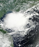
Typhoon Phanfone (Neneng)[]
| Typhoon (JMA) | |
| Category 4 super typhoon (SSHWS) | |
  | |
| Duration | September 28 – October 6 |
|---|---|
| Peak intensity | 175 km/h (110 mph) (10-min) 935 hPa (mbar) |
On September 26, a large area of convection persisted well west of the International Date Line.[136] At the same time, JTWC had classified it as a tropical disturbance.[137] The JMA classified this to a tropical depression on September 28, while the JTWC designated it as 18W the next day. On September 29, 18W intensified into Tropical Storm Phanfone, due to very favorable conditions and intense thunderstorms rich with convection surrounding the storm's center. Due to these factors, Phanfone continued displaying signs of intensification later that day.[138][139] Phanfone strengthened into a minimal typhoon late on September 30. But due to warm sea-surface temperatures and very favorable environments, Phanfone underwent rapid deepening on October 1.[140] The next day, Phanfone strengthened into a category 4 typhoon. However, the storm then weakened to a category 3. This is due to its eye replacing the old one and undergoing a minor eyewall replacement cycle,[141] although the JTWC upgraded Phanfone to a category 4 again late on October 3. At the same time, Phanfone entered the PAR, with PAGASA assigning the name Neneng,[142] although the storm exited the basin several hours later.[143] On October 4, Phanfone reached its peak intensity, with the JTWC classifying it as a super typhoon.[144] The storm steadily weaked as it approached Japan, and after it affected Japan, the JTWC issued its last advisory on the system on October 6, as it tracked northeastwards and extremely affected by strong vertical wind shear.[145]
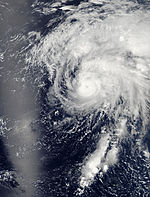
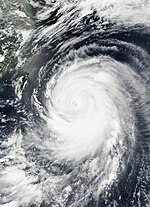
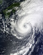
Typhoon Vongfong (Ompong)[]
| Typhoon (JMA) | |
| Category 5 super typhoon (SSHWS) | |
  | |
| Duration | October 2 – October 14 |
|---|---|
| Peak intensity | 215 km/h (130 mph) (10-min) 900 hPa (mbar) |
On October 2, the JMA started to monitor a tropical depression that had developed over in the Marshall Islands.[146] During the next day, it was deemed as 19W by the JTWC,[147] and was upgraded to Tropical Storm Vongfong a few hours later. Due to a strong outflow, Vongfong intensified into a minimal typhoon as it affected the Mariana Islands. During the next day, Vongfong entered an area of favorable environments where it allowed the system to undergo a phase of rapid deepening, and as a result, it was upgraded to a Category 3 typhoon by the JTWC later that day on October 7.[147] Late on October 7, PAGASA declared that Vongfong had entered their area of responsibility, and named it Ompong.[148] On October 8, Vongfong explosively intensified from a Category 3 to a Category 5 super typhoon, where it peaked with winds of 215 kilometres per hour (134 mph) and a minimum pressure of 900 hPa, making Vongfong the most powerful tropical cyclone of 2014,[149][146][147] and the most intense since Typhoon Haiyan.[150] Although Vongfong maintained its intensity, the typhoon undergo an eyewall replacement cycle and this made Vongfong to weaken late the next day.[146] On October 10, the JTWC downgraded Vongfong to a category 3 typhoon, as its convection started to weakened slightly. This also made the system weakened to a category 2 typhoon early on October 11, and passed by the island of Okinawa.[147] Vongfong made landfall over southwestern Japan on October 13, just as both agencies downgraded it to a strong tropical storm, though the JTWC issued its final warning a few hours later.[146][147] Dry air surrounded to southern periphery of Vongfong as the JMA issued its final advisory early on October 14. Vongfong's extratropical remnants exited basin early on October 16, and fully dissipated a day later.[146]
Typhoon Nuri (Paeng)[]
| Typhoon (JMA) | |
| Category 5 super typhoon (SSHWS) | |
  | |
| Duration | October 30 – November 6 |
|---|---|
| Peak intensity | 205 km/h (125 mph) (10-min) 910 hPa (mbar) |
The JMA started to track tropical depression on October 30 in the Philippine Sea.[151] On the following day, the JTWC issued warnings on the tropical depression, which was designated as 20W.[152] Later that day, both agencies upgraded 20W to a tropical storm, with the name Nuri.[151] Early on November 1, Nuri gradually intensified as it entered the PAR, with PAGASA naming it Paeng.[153] Later that day, the JMA upgraded the storm to a severe tropical storm.[151] Due to an increase of convective activity, Nuri had rapidly intensified into a typhoon by both agencies.[152] On November 2, Nuri had undergone a phase of rapid deepening from a minimal typhoon to a super typhoon in a period of 24 hours.[152] Late on November 2, Nuri had attained its peak intensity, with maximum sustained winds of 285 kilometres per hour (177 mph), tied with Vongfong, though its minimum pressure was recorded at 910 hPa.[151] Some shear and cool sea-surface temperatures caused Nuri to weaken later that day as it rapidly moved northeastward.[152] Both the JMA and the JTWC downgraded Nuri to a Category 3 typhoon on November 5. Around that time, the storm underwent an eyewall replacement cycle and Nuri quickly weakened, due to vertical wind shear.[152] During November 6, Nuri had transitioned into an extratropical cyclone, as both agencies stopped issuing advisories on the system. Nuri's extratropical remnant split into two low-pressure systems on November 7, and Nuri's original low was later absorbed by the new, more powerful extratropical cyclone on the same day.[151]
Tropical Storm Sinlaku (Queenie)[]
| Tropical storm (JMA) | |
| Tropical storm (SSHWS) | |
  | |
| Duration | November 26 – November 30 |
|---|---|
| Peak intensity | 85 km/h (50 mph) (10-min) 990 hPa (mbar) |
On November 23, a cluster of thunderstorms was located near the equator. Late on November 24, a broad area of low-pressure develops well east of Mindanao, Philippines. On November 26, the area gradually developed convection near its center and PAGASA had upgraded it to Tropical Depression Queenie.[154] Later the same day, both the JMA and the JTWC classified Queenie as a tropical depression, with the JTWC also designating it as 21W.[155][156] On November 28, the JMA upgraded the system to a tropical storm, assigning the name Sinlaku,[157] while the JTWC followed suit. Due to low vertical windshear, Sinlaku gathered strength while it was on the South China Sea. The next day, convective activity increased near the storm's center. At the same time, the JMA upgraded Sinlaku to a severe tropical storm, however according to its best track, the JMA peaked its intensity as a strong tropical storm. Later that day, Sinlaku made landfall over Vietnam as it started to weaken. Both agencies downgraded the system to a tropical depression early on November 30 and made their final advisories later that day.
As a tropical depression, Sinlaku lashed the Visayas, killed 4 people and the infrastructural damage were at Php2.66 million (US$60,000).[158] Damage in Vietnam were standing at VND 90 billion (US$4.2 million).[159]
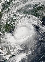
Typhoon Hagupit (Ruby)[]
| Typhoon (JMA) | |
| Category 5 super typhoon (SSHWS) | |
  | |
| Duration | November 30 – December 12 |
|---|---|
| Peak intensity | 215 km/h (130 mph) (10-min) 905 hPa (mbar) |
On November 30, the JMA started to track a tropical depression about 530 km (330 mi) south-southwest of Kosrae,[160] however operationally it was tracked early the next day. By December 1, the JTWC started issuing advisories as the system has intensified into a tropical storm, assigning the name Hagupit.[160][161] Hagupit intensified into a typhoon the next day. During December 3, Hagupit started to undergo a phase of explosive intensification from a Category 2 typhoon to a Category 5 super typhoon, as a clear and well-defined eye developed.[161] Later the same day, Hagupit entered the PAR, with PAGASA giving the name Ruby. Early on December 4, Hagupit reached its peak intensity with 10-minute sustained winds of 215 kilometres per hour (134 mph) and a minimum barometric pressure of 905 hPa.[160][161] Thereafter, the typhoon encountered moderate vertical windshear from the east and started an eyewall replacement cycle as it weakened to a Category 4 super typhoon. The JTWC downgraded Hagupit to a Category 3 typhoon just before December 7.[161] Hagupit made landfall over Eastern Samar and encountered land reaction, as it further weakened to a Category 2 typhoon.[162][161] Hours later, the system moved in a northwestward direction and made its second landfall over Masbate.[163] The next day, both agencies downgraded Hagupit to a severe tropical storm, due to its continued slow movement and land reaction as it made its third landfall over the island of Marinduque.[160][161] During its fourth landfall over Batangas, the JMA downgraded it to a tropical storm.[164] On December 9, Hagupit emerged to the South China Sea, retaining its tropical storm intensity.[161] Although due to an increase of deep convection near the center, Hagupit slightly strengthened, though its intensity remained at tropical storm strength.[160] By December 12, Hagupit weakened to a tropical depression until both agencies issued their final advisory on the storm.[161] The JMA tracked it until it dissipated just southeast of Ho Chi Minh City, Vietnam later the same day.[160]
Tropical Storm Jangmi (Seniang)[]
| Tropical storm (JMA) | |
| Tropical storm (SSHWS) | |
  | |
| Duration | December 28, 2014 – January 1, 2015 |
|---|---|
| Peak intensity | 75 km/h (45 mph) (10-min) 996 hPa (mbar) |
On December 28, Tropical Depression 23W developed about 630 km (390 mi) to the west of the island of Palau.[165][166] PAGASA also named the system as Seniang.[167] A few hours later, the system had rapidly organized and was considered as a tropical storm, with the name Jangmi.[165][166] By December 29, Jangmi made landfall over the town of Hinatuan in the province of Surigao del Sur and briefly reached its peak strength packing maximum winds of 85 kilometres per hour (53 mph).[166] The storm traversed the Caraga region, and exited the landmass of Mindanao as the system had slowly weakened.[165] During the next day, Jangmi made landfall over Cebu and southern Negros, right before the JTWC downgraded it to a tropical depression.[166] Both agencies made their final warning on Jangmi on January 1, 2015, as the 2015 Pacific typhoon season started.[165][166]
Other systems[]
During March 11, the JMA monitored a tropical depression that had developed about 195 km (120 mi) to the east of Mati City, Philippines.[168] Over the next day the system moved westwards, before it was last noted within the Celebes Sea on March 12.[168] On April 19, the JMA reported that a tropical depression had developed about 490 km (300 mi) southwest of Hagåtña, Guam.[169] Due to less convection and cool waters on April 21, the depression weakened to a disturbance while still moving west. The remnants of the depression affected the northern Philippines and dissipated on April 23, due to land interaction.[170][171] On July 19, a tropical depression formed to the southeast of Guam.[172] It slowly moved in a northwest direction over the next few days.[173] Early on July 22, the JTWC issued a TCFA Alert, but later that day, the system lost its organization, and was downgraded to a low-pressure area.[174][175] On August 19, the JMA briefly monitored a tropical depression, that had developed along the coast of China to the northeast of Hong Kong.[176][177]
During August 24, from a post-analysis by the JMA, a tropical depression had developed well to the southeast of Tokyo, Japan.[178] The system dissipated on August 26 as it was absorbed by a cold front associated with an extratropical system to its north.[179] Convectional cloudiness persisted over the Philippines, contributing to bring heavy rainfall on August 25. The area intensified into a low-pressure area as it moved to the South China Sea the next day.[180][181] It was classified as a tropical depression on August 27 by the JMA. The depression affected Hainan Island, Southern China and northern Vietnam by heavy rainfall and flash floods as it was moving in a westward direction.[182] On August 29, the system weakened to an remnant low just east of the 100th meridian east.[183] A low-pressure area formed from an upper-level low several kilometers east-southeast of Japan on August 31.[184] It started to organize and the southern part of the system has winds of tropical depression strength. On September 4, JMA upgraded it to a tropical depression. Although the system moved into an area of moderate vertical wind shear. With this, the system became extratropical late on September 5.[185]
Storm names[]
Within the North-western Pacific Ocean, both the Japan Meteorological Agency (JMA) and the Philippine Atmospheric, Geophysical and Astronomical Services Administration assign names to tropical cyclones that develop in the Western Pacific, which can result in a tropical cyclone having two names.[186] The Japan Meteorological Agency's RSMC Tokyo — Typhoon Center assigns international names to tropical cyclones on behalf of the World Meteorological Organization's Typhoon Committee, should they be judged to have 10-minute sustained windspeeds of 65 km/h (40 mph).[187] While the Philippine Atmospheric, Geophysical and Astronomical Services Administration assigns names to tropical cyclones which move into or form as a tropical depression in their area of responsibility located between 135°E and 115°E and between 5°N-25°N even if the cyclone has had an international name assigned to it.[186] The names of significant tropical cyclones are retired, by both PAGASA and the Typhoon Committee.[187] Should the list of names for the Philippine region be exhausted then names will be taken from an auxiliary list of which the first ten are published each season. Unused names are marked in gray.
International names[]
During the season 22 tropical storms developed in the Western Pacific and each one was named by the JMA, when the system was judged to have 10-minute sustained windspeeds of 65 km/h (40 mph). The JMA selected the names from a list of 140 names, that had been developed by the 14 members nations and territories of the ESCAP/WMO Typhoon Committee.
| Lingling | Kajiki | Faxai | Peipah | Tapah | Mitag | Hagibis | Neoguri | Rammasun | Matmo | Halong |
| Nakri | Fengshen | Kalmaegi | Fung-wong | Kammuri | Phanfone | Vongfong | Nuri | Sinlaku | Hagupit | Jangmi |
Philippines[]
| Agaton | Basyang | Caloy | Domeng | Ester |
| Florita | Glenda | Henry | Inday | Jose |
| Karding | Luis | Mario | Neneng | Ompong |
| Paeng | Queenie | Ruby | Seniang | Tomas (unused) |
| Usman (unused) | Venus (unused) | Waldo (unused) | Yayang (unused) | Zeny (unused) |
| Auxiliary list | ||||
|---|---|---|---|---|
| Agila (unused) | Bagwis (unused) | Chito (unused) | Diego (unused) | Elena (unused) |
| Felino (unused) | Gunding (unused) | Harriet (unused) | Indang (unused) | Jessa (unused) |
During the season PAGASA used its own naming scheme for the 19 tropical cyclones, that either developed within or moved into their self-defined area of responsibility.[188] The names were taken from a list of names, that had been last used during 2010 and are scheduled to be used again during 2018.[188] The names Jose, Karding, Mario and Ruby were used for the first (and only, in cases of Jose, Mario and Ruby) time during the year after the names Juan, Katring, Milenyo and Reming were retired.[188]
Retirement[]
International[]
After the season the Typhoon Committee retired the name Rammasun, and in February 2016, it was subsequently replaced with Bualoi for future seasons.[189]
Philippines[]
At the start of 2014 the name Kanor was originally scheduled to replace Katring, however, PAGASA replaced it with the name Karding during September, after obtaining negative feedback from the public.[190][191]
After the season, the names Glenda, Jose, Mario, Ruby and Seniang were retired by PAGASA, as they had caused over PhP1 billion in damages. They were subsequently replaced on the list with the names Gardo, Josie, Maymay, Rosita and Samuel.[192][193]
Season effects[]
This table will list all the storms that developed in the northwestern Pacific Ocean west of the International Date Line and north of the equator during 2014. It will include their intensity, duration, name, areas affected, deaths, and damage totals. Classification and intensity values will be based on estimations conducted by the JMA. All damage figures will be in 2014 USD. Damages and deaths from a storm will include when the storm was a precursor wave or an extratropical low.
| Name | Dates active | Peak classification | Sustained wind speeds |
Pressure | Areas affected | Damage (USD) |
Deaths | Refs |
|---|---|---|---|---|---|---|---|---|
| Lingling (Agaton) | January 10–20 | Tropical storm | 65 kilometres per hour (40 mph) | 1,002 hPa (29.59 inHg) | Philippines | $12.6 million | 70 | [19] |
| Kajiki (Basyang) | January 29 – February 1 | Tropical storm | 65 kilometres per hour (40 mph) | 1,000 hPa (29.53 inHg) | Philippines | $202,000 | 6 | [19][27] |
| Faxai | February 27 – March 5 | Typhoon | 120 kilometres per hour (75 mph) | 975 hPa (28.79 inHg) | Caroline Islands, Mariana Islands | Minimal | 1 | [36] |
| TD | March 11–12 | Tropical depression | Not specified | 1,008 hPa (29.77 inHg) | Sulawesi | None | None | |
| 04W (Caloy) | March 17–24 | Tropical depression | Not specified | 1,004 hPa (29.65 inHg) | Philippines | None | None | [19] |
| Peipah (Domeng) | April 2–15 | Tropical storm | 65 kilometres per hour (40 mph) | 998 hPa (29.47 inHg) | Caroline Islands | None | None | |
| TD | April 19–21 | Tropical depression | Not specified | 1,004 hPa (29.65 inHg) | Caroline Islands, Philippines | None | None | |
| Tapah | April 27 – May 2 | Severe tropical storm | 95 kilometres per hour (59 mph) | 985 hPa (29.09 inHg) | None | None | None | |
| Mitag (Ester) | June 9–12 | Tropical storm | 75 kilometres per hour (47 mph) | 994 hPa (29.35 inHg) | Philippines, Taiwan, Japan | None | None | |
| Hagibis | June 13–17 | Tropical storm | 75 kilometres per hour (47 mph) | 996 hPa (29.41 inHg) | Philippines, China, Taiwan, Japan | $198 million | None | [62] |
| Neoguri (Florita) | July 2–11 | Typhoon | 185 kilometres per hour (115 mph) | 930 hPa (27.46 inHg) | Caroline Islands, Guam, Japan | $632 million | 3 | [194] |
| Rammasun (Glenda) | July 9–20 | Typhoon | 165 kilometres per hour (103 mph) | 935 hPa (27.61 inHg) | Caroline Islands, Guam, Philippines, China, Vietnam | $8.03 billion | 222 | [195][196][62] |
| Matmo (Henry) | July 16–25 | Typhoon | 130 kilometres per hour (81 mph) | 965 hPa (28.50 inHg) | Palau, Philippines, Taiwan, China, Korea | $418 million | 65 | [83][197][198][62] |
| TD | July 19–22 | Tropical depression | Not specified | 1,008 hPa (29.77 inHg) | Caroline Islands, Mariana Islands | None | None | |
| Halong (Jose) | July 27 – August 11 | Typhoon | 195 kilometres per hour (121 mph) | 920 hPa (27.17 inHg) | Caroline Islands, Mariana Islands, Philippines, Japan, Siberia | $72.8 million | 12 | [199][200] |
| Nakri (Inday) | July 28 – August 4 | Severe tropical storm | 100 kilometres per hour (62 mph) | 980 hPa (28.94 inHg) | Japan, Korea | $114,000 | 15 | [90][91][93] |
| Genevieve | August 7–14 | Typhoon | 205 kilometres per hour (127 mph) | 915 hPa (27.02 inHg) | None | None | None | |
| TD | August 19 | Tropical depression | Not specified | 1,006 hPa (29.71 inHg) | Taiwan, China | None | None | |
| TD | August 24–26 | Tropical depression | Not specified | 1,006 hPa (29.71 inHg) | None | None | None | |
| TD | August 27–29 | Tropical depression | Not specified | 1,004 hPa (29.65 inHg) | China, Vietnam, Laos | None | None | |
| TD | September 4–5 | Tropical depression | Not specified | 1,006 hPa (29.71 inHg) | None | None | None | |
| Fengshen | September 5–10 | Severe tropical storm | 110 kilometres per hour (68 mph) | 975 hPa (28.79 inHg) | Japan | None | None | |
| 14W (Karding) | September 5–8 | Tropical depression | 55 kilometres per hour (34 mph) | 1,004 hPa (29.65 inHg) | Philippines, China, Vietnam | None | None | |
| Kalmaegi (Luis) | September 11–18 | Typhoon | 140 kilometres per hour (87 mph) | 960 hPa (28.35 inHg) | Caroline Islands, Philippines, China, Indochina, India | $2.92 billion | 48 | [117][118][119][62] |
| Fung-wong (Mario) | September 17–24 | Tropical storm | 85 kilometres per hour (53 mph) | 985 hPa (29.09 inHg) | Philippines, Taiwan, Japan, China, South Korea | $231 million | 22 | [129][131][132] |
| Kammuri | September 23–30 | Severe tropical storm | 95 kilometres per hour (59 mph) | 985 hPa (29.09 inHg) | Mariana Islands, Japan | None | None | |
| Phanfone (Neneng) | September 28 – October 6 | Typhoon | 175 kilometres per hour (109 mph) | 935 hPa (27.61 inHg) | Caroline Islands, Mariana Islands, Japan | $100 million | 11 | [201] |
| Vongfong (Ompong) | October 2–14 | Typhoon | 215 kilometres per hour (134 mph) | 900 hPa (26.58 inHg) | Caroline Islands, Mariana Islands, Taiwan, Japan, South Korea, Kamchatka Peninsula, Alaska | $161 million | 9 | [202][203][204][205][206] |
| Nuri (Paeng) | October 30 – November 6 | Typhoon | 205 kilometres per hour (127 mph) | 910 hPa (26.87 inHg) | Japan | Minimal | None | |
| Sinlaku (Queenie) | November 26–30 | Tropical storm | 85 kilometres per hour (53 mph) | 990 hPa (29.23 inHg) | Palau, Philippines, Vietnam, Laos, Cambodia | $4.26 million | 4 | [207][208] |
| Hagupit (Ruby) | November 30 – December 12 | Typhoon | 215 kilometres per hour (134 mph) | 905 hPa (26.72 inHg) | Caroline Islands, Palau, Philippines, Vietnam | $114 million | 18 | [209] |
| Jangmi (Seniang) | December 28 – January 1 | Tropical storm | 75 kilometres per hour (47 mph) | 996 hPa (29.41 inHg) | Philippines, Borneo | $28.4 million | 66 | [210] |
| Season aggregates | ||||||||
| 32 systems | January 10, 2014 – January 1, 2015 | 215 kilometres per hour (134 mph) | 900 hPa (26.58 inHg) | $12.9 billion | 572 | |||
See also[]
- Tropical cyclones in 2014
- List of Pacific typhoon seasons
- List of wettest tropical cyclones
- 2014 Pacific hurricane season
- 2014 Atlantic hurricane season
- 2014 North Indian Ocean cyclone season
- South-West Indian Ocean cyclone seasons: 2013–14, 2014–15
- Australian region cyclone seasons: 2013–14, 2014–15
- South Pacific cyclone seasons: 2013–14, 2014–15
References[]
- ^ Jump up to: a b c d e f g h i j k l Saunders, Mark; Lea, Adam (January 27, 2015). Summary of 2014 NW Pacific Typhoon Season and Verification of Author's Seasonal Forecasts (PDF) (Report). Tropical Storm Risk Consortium. Archived (PDF) from the original on April 6, 2015. Retrieved April 7, 2015.
- ^ Jump up to: a b c d Malano, Vicente B (January 10, 2014). January — June 2014 (Seasonal Climate Outlook). Philippine Atmospheric, Geophysical and Astronomical Services Administration. Archived from the original on May 7, 2014. Retrieved May 7, 2014.
- ^ Jump up to: a b c Three to Five Typhoons Tend to Impinge upon Taiwan during 2014 (Doc) (Report). Taiwan Central Weather Bureau. June 27, 2014. Retrieved July 7, 2014.
- ^ Jump up to: a b c Malano, Vicente B (July 7, 2015). July – December 2014 (Seasonal Climate Outlook). Philippine Atmospheric, Geophysical and Astronomical Services Administration. Archived from the original on February 2, 2015. Retrieved April 18, 2015.
- ^ Annual Report on the Activities of the RSMC Tokyo - Typhoon Center 2014 (PDF) (Report). Japan Meteorological Agency. October 28, 2015. Archived from the original (PDF) on July 27, 2017. Retrieved July 27, 2017.
- ^ Annual Tropical Cyclone Report 2014 (PDF) (Report). United States Joint Typhoon Warning Center. October 9, 2015. Archived from the original (PDF) on July 27, 2017. Retrieved July 27, 2017.
- ^ "Winter — Spring Season Outlook (From November 2013 to April 2014)". Vietnamese National Center for Hydro Meteorological forecasts. October 4, 2013. Archived from the original on October 14, 2013. Retrieved October 14, 2013.
- ^ Chi-ming, Shun (March 17, 2014). "Speech by Mr Shun Chi-ming, Director of the Hong Kong Observatory March 17, 2014" (PDF). Hong Kong Observatory. Archived (PDF) from the original on April 6, 2015. Retrieved April 6, 2015.
- ^ Jump up to: a b "RSMC Tropical Cyclone Advisory 101200". Japan Meteorological Agency. Archived from the original on January 11, 2014. Retrieved April 5, 2015.
- ^ Young, Steve (February 20, 2014). "Monthly Global Tropical Cyclone Tracks: January 2014". Australian Severe Weather. Archived from the original on October 26, 2014. Retrieved October 26, 2014.
- ^ "Significant Tropical Weather Advisory for the Western and South Pacific Oceans January 10, 2014 18z". Joint Typhoon Warning Center. Archived from the original on January 11, 2014. Retrieved August 23, 2014.
- ^ "Marine Weather Warning for GMDSS Metarea XI 2014-01-12T18:00:00Z". WIS Portal – GISC Tokyo. Japan Meteorological Agency. Retrieved August 25, 2014.
- ^ "Significant Tropical Weather Advisory for the Western and South Pacific Oceans 120600Z-130600Z Jan 2014". Joint Typhoon Warning Center. Archived from the original on August 25, 2014. Retrieved August 25, 2014.
- ^ "Marine Weather Warning for GMDSS Metarea XI 2014-01-13T12:00:00Z". WIS Portal – GISC Tokyo. Japan Meteorological Agency. Retrieved August 25, 2014.
- ^ "Marine Weather Warning for GMDSS Metarea XI 2014-01-14T06:00:00Z". WIS Portal – GISC Tokyo. Japan Meteorological Agency. Retrieved August 25, 2014.
- ^ Jump up to: a b c "Tropical Cyclone Best Track 1401 Lingling (1401)". Japan Meteorological Agency. Archived from the original on February 17, 2014.CS1 maint: bot: original URL status unknown (link)
- ^ "Tropical Depression "AGATON" Weather Bulletin Number ONE". Philippine Atmospheric, Geophysical and Astronomical Services Administration. Archived from the original on January 17, 2014. Retrieved August 25, 2014.
- ^ Jump up to: a b "JTWC Best Track Data for Tropical Depression 01W (Lingling)".
- ^ Jump up to: a b c d e f g h i j k PAGASA, Philippines (PDF). ESCAP/WMO Typhoon Committee 9th Integrated Workshop October 20–23, 2014 (Member Report). January 4, 2015. Archived (PDF) from the original on April 5, 2015. Retrieved April 5, 2015.
- ^ Jump up to: a b c d "NDRRMC Updates Sitrep No. 33 re: Effects of Tropical Depression "Agaton"" (PDF). National Disaster Risk Reduction and Management Council. February 1, 2014. Archived from the original (PDF) on November 30, 2014. Retrieved November 30, 2014.
- ^ Jump up to: a b RSMC Tokyo — Typhoon Center (February 17, 2014). Tropical Storm Kajiki (RSMC Tropical Cyclone Best Track). Japan Meteorological Agency. Archived from the original on February 20, 2014. Retrieved November 2, 2014.
- ^ "PROGNOSTIC REASONING FOR TROPICAL DEPRESSION 02W (TWO) WARNING". Archived from the original on January 29, 2014.
- ^ Jump up to: a b "PROGNOSTIC REASONING FOR TROPICAL DEPRESSION 02W (TWO) WARNING". Archived from the original on January 31, 2014.
- ^ "Tropical Storm Basyang – Weather Bulletin Number Five-A". PAGASA. January 31, 2014. Archived from the original on January 31, 2014. Retrieved February 2, 2014.
- ^ "Tropical Cyclone Advisory – February 1, 2014 1200 UTC". Japan Meteorological Agency. February 1, 2014. Archived from the original on February 1, 2014. Retrieved February 2, 2014.
- ^ "Tropical Depression 02W (Kajiki) Warning Number 009". Joint Typhoon Warning Center. February 1, 2014. Archived from the original on February 1, 2014. Retrieved February 2, 2014.
- ^ Jump up to: a b c "Final Report: Re: Effects of Tropical Storm Basyang (IN: Kajiki)" (PDF). National Disaster Risk Reduction and Management Council. February 6, 2014. Archived from the original (PDF) on August 1, 2016. Retrieved August 1, 2016.
- ^ Jump up to: a b RSMC Tokyo — Typhoon Center (March 18, 2014). Typhoon Faxai (RSMC Tropical Cyclone Best Track). Japan Meteorological Agency. Archived from the original on March 18, 2014. Retrieved June 14, 2014.
- ^ "Tropical Depression 03W (Three) Warning Nr 001". Joint Typhoon Warning Center. Archived from the original on February 28, 2014. Retrieved September 28, 2014.
- ^ "Tropical Depression 03W Develops in West Pacific Basin". Retrieved February 28, 2014.
- ^ "WTPQ20 RJTD 281200 - RSMC TROPICAL CYCLONE ADVISORY". Japan Meteorological Agency. Archived from the original on February 28, 2014. Retrieved September 28, 2014.
- ^ "Tropical Storm Faxai southeast of Guam, moving northwest". Archived from the original on July 7, 2014. Retrieved February 28, 2014.
- ^ "WTPQ20 RJTD 041800 - RSMC TROPICAL CYCLONE ADVISORY". Japan Meteorological Agency. Archived from the original on March 5, 2014. Retrieved September 28, 2014.
- ^ "Prognostic Reasoning For Typhoon 03W (Faxai) Warning Nr 20". Joint Typhoon Warning Center. Archived from the original on March 5, 2014. Retrieved September 28, 2014.
- ^ "NASA Satellite Sees Faxai Hit Typhoon Strength". NASA, Rob Gutro. Retrieved March 4, 2014.
- ^ Jump up to: a b Event Details: Rip Current: Guam (Storm Events Database). National Oceanic and Atmospheric Administration's National Climatic Data Center. Archived from the original on November 30, 2014. Retrieved November 30, 2014.
- ^ "JMA WWJP25 Warning and Summary March 18, 2014 0600 UTC". Japan Meteorological Agency. March 18, 2014. Archived from the original on March 18, 2014. Retrieved October 7, 2016.
- ^ "WTPH20 RPMM 201800 T T T — WARNING 01". Philippine Atmospheric, Geophysical and Astronomical Services Administration. Archived from the original on March 22, 2014. Retrieved September 28, 2014.
- ^ Jump up to: a b "JTWC Best Track for Tropical Depression 04W (Four)". Joint Typhoon Warning Center. April 6, 2015.
- ^ "Significant Tropical Weather Advisory For The Western And South Pacific Oceans 010600Z-020600ZApr2014". Joint Typhoon Warning Center. Archived from the original on April 1, 2014. Retrieved September 28, 2014.
- ^ Jump up to: a b c d "Tropical Cyclone Best Track 1404 Peipah (1404)". Japan Meteorological Agency. Archived from the original on May 19, 2014.CS1 maint: bot: original URL status unknown (link)
- ^ Jump up to: a b "JTWC Best Track Data for Tropical Storm 05W (Peipah)". Joint Typhoon Warning Center.
- ^ "WTPH20 RPMM 060600 – TTT WARNING 01". Philippine Atmospheric, Geophysical and Astronomical Services Administration. Archived from the original on April 7, 2014. Retrieved September 28, 2014.
- ^ "WTPH20 RPMM 091800 TTT - WARNING (FINAL)". Philippine Atmospheric, Geophysical and Astronomical Services Administration. Archived from the original on April 15, 2014. Retrieved September 28, 2014.
- ^ "Significant Tropical Weather Advisory For The Western And South Pacific Oceans 120200Z-120600ZApr2014". Joint Typhoon Warning Center. Archived from the original on April 12, 2014. Retrieved September 28, 2014.
- ^ Jump up to: a b "Significant Tropical Weather Advisory For The Western And South Pacific Oceans 150600Z-160600ZApr2014". Joint Typhoon Warning Center. Archived from the original on April 15, 2014. Retrieved September 28, 2014.
- ^ Jump up to: a b c d RSMC Tokyo — Typhoon Center (May 21, 2014). Severe Tropical Storm Tapah (RSMC Tropical Cyclone Best Track). Japan Meteorological Agency. Archived from the original on May 23, 2014. Retrieved April 18, 2015.
- ^ "Tropical Depression 06W (Six) Warning Number 001". Joint Typhoon Warning Center. April 27, 2014. Archived from the original on April 27, 2014. Retrieved April 27, 2014.
- ^ "Tropical Cyclone Advisory – April 28, 2014 0000 UTC". Japan Meteorological Agency. April 28, 2014. Archived from the original on April 28, 2014. Retrieved April 28, 2014.
- ^ "Prognostic Reasoning For Tropical Storm 06W (Tapah) Warning Nr 05". Joint Typhoon Warning Center. Archived from the original on April 29, 2014. Retrieved September 28, 2014.
- ^ "Tropical Cyclone Advisory – April 29, 2014 0000 UTC". Japan Meteorological Agency. April 29, 2014. Archived from the original on April 29, 2014. Retrieved April 29, 2014.
- ^ "Typhoon 06W (Tapah) Warning Number 007". Joint Typhoon Warning Center. April 29, 2014. Archived from the original on April 29, 2014. Retrieved April 29, 2014.
- ^ Joint Typhoon Warning Center (May 2, 2014). "Tropical Depression 06W (Tapah) Warning 16". United States Navy, United States Airforce. Archived from the original on May 2, 2014. Retrieved June 14, 2014.
- ^ Jump up to: a b c "Tropical Cyclone Best Track 1406 Mitag (1406)". Japan Meteorological Agency. June 25, 2014. Archived from the original on June 27, 2014.CS1 maint: bot: original URL status unknown (link)
- ^ "Severe Weather Bulletin Number One – Tropical Cyclone Warning: Tropical Depression "Ester"". Philippine Atmospheric, Geophysical and Astronomical Services Administration. Archived from the original on June 11, 2014. Retrieved September 28, 2014.
- ^ "Significant Tropical Weather Outlook for the Western and South Pacific Ocean 112300Z-120600ZJun2014". Joint Typhoon Warning Center. June 11, 2014. Archived from the original on June 12, 2014. Retrieved June 12, 2014.
- ^ Andrade, Jeannette. "It's official: Wet season is here". Inquirer. Retrieved June 10, 2014.
- ^ Placido, Dharel. "Rainy season is here; Signal No. 1 in 3 areas". ABS-CBN News. Retrieved June 10, 2014.
- ^ Jump up to: a b c d e "Tropical Cyclone Best Track 1407 Hagibis (1407)". Japan Meteorological Agency. July 17, 2014. Archived from the original on July 17, 2014.CS1 maint: bot: original URL status unknown (link)
- ^ Jump up to: a b c d "JTWC Best Track Data for Tropical Storm 07W (Hagibis)". Joint Typhoon Warning Center. May 6, 2015.
- ^ "Tropical storm Hagibis hits Guandong – China". Retrieved June 15, 2014.
- ^ Jump up to: a b c d e "Member Report: China" (PDF). CMA. China Meterelogical Agency. Retrieved October 18, 2014.
- ^ Jump up to: a b c d e "Tropical Cyclone Best Track 1408 Neoguri (1408)". Japan Meteorological Agency. August 18, 2014. Archived from the original on August 18, 2014.CS1 maint: bot: original URL status unknown (link)
- ^ Jump up to: a b c d e "JTWC Best Track Data for Super Typhoon 08W (Neoguri)". Joint Typhoon Warning Center. June 10, 2015.
- ^ "Severe Weather Bulletin Number One – Tropical Cyclone Alert: Typhoon "Florita" (Neoguri)". Philippine Atmospheric, Geophysical and Astronomical Services Administration. Archived from the original on July 6, 2014. Retrieved October 6, 2014.
- ^ "Prognostic Reasoning For Super Typhoon 08W (Neoguri) Warning Nr 16". Joint Typhoon Warning Center. Archived from the original on July 7, 2014. Retrieved October 6, 2014.
- ^ "Typhoon Florita exits Philippines". Retrieved July 8, 2014.
- ^ "Typhoon Neoguri weakens to tropical storm as Japan evacuates 90,000". July 10, 2014.
- ^ "Archived copy" 台風第8号及び梅雨前線の影響に伴う7月6日からの大雨等による被害状況等について(第15報) (PDF) (in Japanese). Fire and Disaster Management Agency. July 16, 2014. Archived from the original (PDF) on August 8, 2014. Retrieved July 30, 2014.CS1 maint: archived copy as title (link)
- ^ 沖縄 18市町村の約54万人に避難勧告 [Evacuation of about 540,000 people in 18 municipalities in Okinawa Prefecture]. NHK NEWSWeb (in Japanese). Japan Broadcasting Corporation. July 8, 2014. Archived from the original on July 13, 2014. Retrieved July 9, 2014.
- ^ Jacob Adelman (July 9, 2014). "Japan City Evacuates 90,000 as Typhoon Nears Kyushu". Bloomberg. Retrieved July 9, 2014.
- ^ 平成26年発生災害について (PDF) (Report). 全国防災協会. 2015. Retrieved July 8, 2015.
- ^ "<熱中症>8都県で150人超搬送". 毎日新聞. Yahoo! News. July 12, 2014. Archived from the original on July 13, 2014. Retrieved July 12, 2014.
- ^ Jump up to: a b c d e f "Tropical Cyclone Best Track 1409 Rammasun (1409)". Japan Meteorological Agency. August 19, 2014. Archived from the original on August 19, 2014.CS1 maint: bot: original URL status unknown (link)
- ^ Jump up to: a b c d e f "JTWC Best Track Data for Super Typhoon 09W (Rammasun)". Joint Typhoon Warning Center. July 6, 2015.
- ^ "Severe Weather Bulletin Number One Tropical Cyclone Alert: Tropical Storm "Glenda" (Rammasun)". Philippine Atmospheric, Geophysical and Astronomical Services Administration. July 13, 2014. Archived from the original on July 14, 2014. Retrieved May 4, 2015.
- ^ "Glenda death toll now at 40, agri damage breaches P1B". Retrieved July 17, 2014.
- ^ "Typhoon Rammasun kills 18 in China". Retrieved July 20, 2014.
- ^ Jump up to: a b c d "Tropical Cyclone Best Track 1410 Matmo (1410)". Japan Meteorological Agency. August 19, 2014. Archived from the original on August 20, 2014.CS1 maint: bot: original URL status unknown (link)
- ^ Jump up to: a b c d "JTWC Best Track Data for Typhoon 10W (Matmo)". Joint Typhoon Warning Center. June 13, 2015.
- ^ "Tropical storm enters PAR, codenamed Henry". Joel Locsin, LBG GMA News. Retrieved July 18, 2014.
- ^ "Typhoon Matmo slams into Taiwan, one killed". Retrieved July 23, 2014.
- ^ Jump up to: a b "Taiwan: 48 dead in TransAsia Airways plane crash". The Guardian. Taipei, Taiwan. July 24, 2014. Retrieved July 24, 2014.
- ^ "Typhoon Matmo leaves 13 injuries, no fatalities". Joy Lee. Retrieved July 24, 2014.
- ^ Jump up to: a b c d e "Tropical Cyclone Best Track 1411 Halong (1411)". Japan Meteorological Agency. September 3, 2014. Archived from the original on September 3, 2014.CS1 maint: bot: original URL status unknown (link)
- ^ Jump up to: a b c d e "JTWC Best Track Data for Super Typhoon 11W (Halong)". Joint Typhoon Warning Center. June 6, 2015.
- ^ "Typhoon 'Jose' enters PAR". Retrieved August 2, 2014.
- ^ Jump up to: a b c "Tropical Cyclone Best Track 1412 Nakri (1412)". Japan Meteorological Agency. September 17, 2014. Archived from the original on September 17, 2014.CS1 maint: bot: original URL status unknown (link)
- ^ Jump up to: a b "JTWC Best Track Data for Tropical Storm 12W (Nakri)". Joint Typhoon Warning Center. June 17, 2015.
- ^ Jump up to: a b Mario C. Manlupig Jr. (August 1, 2014). "LPA leaves over P5-M damages in MisOr". Sun Star. Retrieved August 4, 2014.
- ^ Jump up to: a b "10 killed as typhoon Nakri lashes South Korea". Retrieved August 4, 2014.
- ^ 태풍 나크리 해남 15억7300만원 피해 (in Korean). Sun Star. August 16, 2014. Retrieved August 20, 2014.
- ^ Jump up to: a b Sean Breslin (August 6, 2014). "Japan Landslide in Anan, Tokushima Prefecture, Leaves Cars Dangling, 1 Dead". The Weather Channel. Retrieved August 6, 2014.
- ^ 平成 26 年の水害被害額(確報値)を公表 (PDF) (Report) (in Japanese). Ministry of Land, Infrastructure, Transport and Tourism. March 25, 2016. Retrieved August 7, 2016.
- ^ "NASA sees Genevieve cross International Date Line as a Super-Typhoon". NASA. Retrieved August 7, 2014.
- ^ "Prognostic Reasoning for Super Typhoon 11W [sic] (Genevieve) Warning Nr 42". Joint Typhoon Warning Center. Archived from the original on August 8, 2014. Retrieved August 15, 2014.
- ^ "RSMC Tropical Cyclone Advisory 071800". Japan Meteorological Agency. Archived from the original on August 8, 2014. Retrieved August 15, 2014.
- ^ "Prognostic Reasoning for Super Typhoon 07E (Genevieve) Warning Nr 46". Joint Typhoon Warning Center. Archived from the original on August 10, 2014. Retrieved August 15, 2014.
- ^ "Prognostic Reasoning for Typhoon 07E (Genevieve) Warning Nr 46". Joint Typhoon Warning Center. Archived from the original on August 10, 2014. Retrieved August 15, 2014.
- ^ "Prognostic Reasoning for Typhoon 07E (Genevieve) Warning Nr 49". Joint Typhoon Warning Center. Archived from the original on August 10, 2014. Retrieved August 15, 2014.
- ^ "Prognostic Reasoning for Typhoon 07E (Genevieve) Warning Nr 51". Joint Typhoon Warning Center. Archived from the original on August 10, 2014. Retrieved August 15, 2014.
- ^ "Prognostic Reasoning for Typhoon 07E (Genevieve) Warning Nr 52". Joint Typhoon Warning Center. Archived from the original on August 10, 2014. Retrieved August 15, 2014.
- ^ "RSMC Tropical Cyclone Advisory 111200". Japan Meteorological Agency. Archived from the original on August 12, 2014. Retrieved August 15, 2014.
- ^ "Tropical Depression 07E (Genevieve) Warning Nr 59". Joint Typhoon Warning Center. United States Navy. Archived from the original on August 12, 2014. Retrieved August 15, 2014.
- ^ "High Seas Forecast for METAREA XII 1145 UTC Fri Aug 15 2014". Ocean Prediction Center. Archived from the original on August 15, 2014. Retrieved August 15, 2014.
- ^ "High Seas Forecast for METAREA XII 1745 UTC Fri Aug 15 2014". Ocean Prediction Center. Archived from the original on August 15, 2014. Retrieved August 15, 2014.
- ^ Jump up to: a b c d "Tropical Cyclone Best Track 1414 Fengshen (1414)". October 17, 2014. Archived from the original on January 9, 2015.CS1 maint: bot: original URL status unknown (link)
- ^ Jump up to: a b c "JTWC Best Track for Typhoon 13W (Fengshen)". Joint Typhoon Warning Center. April 10, 2015.
- ^ "JMA WWJP25 Warning and Summary September 5, 2014 18z". Japan Meteorological Agency. September 5, 2014. Archived from the original on September 9, 2014. Retrieved October 7, 2016.
- ^ "Tropical Depression "Karding" Flooding parts of Hainan". Robert Speta. Archived from the original on September 8, 2014. Retrieved September 7, 2014.
- ^ "NASA catches the end of Tropical Depression 14W". Rob Gutro, NASA. Retrieved September 9, 2014.
- ^ Jump up to: a b c d e "Tropical Cyclone Best Track 1415 Kalmaegi (1415)". Japan Meteorological Agency. October 17, 2014. Archived from the original on October 18, 2014.CS1 maint: bot: original URL status unknown (link)
- ^ Jump up to: a b c d "JTWC Best Track Data for Typhoon 15W (Kalmaegi)". June 4, 2015.
- ^ "Tropical depression Luis enters PHL, may bring rain this weekend". Joel Locsin. Retrieved September 12, 2014.
- ^ "NDRRMC: Pangasinan town in state of calamity due to Luis, revised death toll up to 4". Joel Locsin, GMA News. Retrieved September 17, 2014.
- ^ "Ilang bahagi ng Pangasinan, lubog pa rin sa baha; bayan ng Calasiao, isinailalim sa state of calamity". FRJ, GMA News. Retrieved September 16, 2014.
- ^ Jump up to: a b "Final Report re Effects of Typhoon "LUIS" (KALMAEGI)" (PDF). NDRRMC. Retrieved September 19, 2014.
- ^ Jump up to: a b "13 dead, 15 injured by Typhoon Kalmaegi". Retrieved September 19, 2014.
- ^ Jump up to: a b "Landslides, flash floods in Meghalaya kill 7". Retrieved September 22, 2014.
- ^ Jump up to: a b c d e "Tropical Cyclone Best Track 1416 Fung-wong (1416)". Japan Meteorological Agency. October 27, 2014. Archived from the original on October 27, 2014.CS1 maint: bot: original URL status unknown (link)
- ^ "Tropical depression 'Mario' enters PAR, expected to exit Saturday". Bong Lozada. Retrieved September 17, 2014.
- ^ Jump up to: a b c "JTWC Best Track Data for Tropical Storm 16W (Fung-wong)". Joint Typhoon Warning Center. June 14, 2014.
- ^ "'Mario' makes landfall over Cagayan". Retrieved September 19, 2014.
- ^ "Typhoon Fung-Wong Drenches Shanghai, Interrupts Traffic". Fu Yu. Retrieved September 23, 2014.
- ^ "Marikina placed under state of calamity". Retrieved September 19, 2014.
- ^ "Still more flooding expected as red rainfall warning remains up in NCR, 7 provinces". Retrieved September 19, 2014.
- ^ "Cancelled flights: Friday, September 19". Retrieved September 19, 2014.
- ^ "Meralco widens power shut-offs in Metro Manila, nearby provinces". Retrieved September 19, 2014.
- ^ Jump up to: a b "SitRep No. 17 re Effects of Tropical Storm "MARIO" (FUNG-WONG)" (PDF). Archived from the original (PDF) on October 6, 2014. Retrieved September 30, 2014.
- ^ "Bagyong Mario, lalong lumakas habang papalapit ng bansa". GMA News. Retrieved September 18, 2014.
- ^ Jump up to: a b "Three deaths reported as tropical storm Fung-Wong lashes Taiwan". September 21, 2014. Retrieved September 22, 2014.
- ^ Jump up to: a b "台风"凤凰"致浙江百余万人受灾". Archived from the original on December 6, 2017. Retrieved September 24, 2014.
- ^ Jump up to: a b c d "Tropical Cyclone Best Track 1417 Kammuri (1417)". October 27, 2014. Archived from the original on October 27, 2014.CS1 maint: bot: original URL status unknown (link)
- ^ Jump up to: a b "JTWC Best Track for Tropical Storm 17W (Kammuri)". Joint Typhoon Warning Center. May 6, 2015.
- ^ "NASA-NOAA's Suomi NPP satellite sees Tropical Storm Kammuri coming together". NASA. September 26, 2014.
- ^ "Tropical Storm Kammuri And Weekend Weather Outlook". Robert Speta. September 25, 2014. Archived from the original on October 1, 2014. Retrieved September 26, 2014.
- ^ "Kammuri skirts Japan and whats next for the tropics?". Robert Speta. September 28, 2014. Archived from the original on October 6, 2014.
- ^ "Newborn Tropical Storm Phanfone triggers warnings in Northwestern Pacific". NASA. Retrieved September 29, 2014.
- ^ "Phanfone nears Saipan, Typhoon Watches in place & long range forecast". Robert Speta. Archived from the original on October 6, 2014. Retrieved September 29, 2014.
- ^ "Rapidly Intensifying Typhoon Phanfone Threatens Japan". Robert Speta. October 1, 2014. Archived from the original on October 6, 2014. Retrieved October 2, 2014.
- ^ "Tropical Depression 19W Forms as Typhoon Phanfone Threatens Japan". rpweather. Retrieved October 3, 2014.
- ^ "Typhoon 'Neneng' inside PAR, but won't affect country". October 3, 2014. Archived from the original on October 5, 2014.
- ^ "Typhoon Neneng exits PAR; gale warnings up over north Luzon". GMA News. October 4, 2014.
- ^ "Phanfone reaches super typhoon status". Chillymanjaro. Retrieved October 4, 2014.
- ^ "Tropical Storm 18W (Phanfone) Warning Nr 031". Joint Typhoon Warning Center. Archived from the original on October 6, 2014. Retrieved October 6, 2014.
- ^ Jump up to: a b c d e "Tropical Cyclone Best Track 1419 Vongfong (1419)". Japan Meteorological Agenncy. November 21, 2014. Archived from the original on November 21, 2014.CS1 maint: bot: original URL status unknown (link)
- ^ Jump up to: a b c d e "JTWC Best Track Data for Super Typhoon 19W (Vongfong)". Joint Typhoon Warning Center. June 27, 2015.
- ^ "Typhoon Owlette enters PAR". October 7, 2014.
- ^ "Super Typhoon Vongfong Turns Into 2014's Strongest Storm". October 8, 2014.
- ^ "Super Typhoon Vongfong: Most Powerful Cyclone Since Haiyan Producing 50ft Waves". Hanna Osborne. October 9, 2014.
- ^ Jump up to: a b c d e "Tropical Cyclone Best Track 1420 Nuri (1420)". Japan Meteorological Agency. November 26, 2014. Archived from the original on November 26, 2014.CS1 maint: bot: original URL status unknown (link)
- ^ Jump up to: a b c d e "JTWC Best Track Data for Super Typhoon 20W (Nuri)". Joint Typhoon Warning Center. June 5, 2015.
- ^ "Weather Bulletin Number One". PAGASA. Archived from the original on November 5, 2014. Retrieved November 5, 2014.
- ^ "LPA intensifies into TD Queenie; signal 1 over parts of Vis-Min". Joel Locsin, GMA News. Retrieved November 26, 2014.
- ^ "Guidance – Forecast Track by Numerical Weather Prediction 2014-11-26T18:00:00Z". Japan Meteorological Agency. Archived from the original on December 2, 2014. Retrieved November 26, 2014.
- ^ "Tropical Depression QUEENIE (21W) Update Number 001". Archived from the original on December 5, 2014. Retrieved November 27, 2014.
- ^ "Guidance – Forecast Track by Numerical Weather Prediction 2014-11-28T18:00:00Z". Japan Meteorological Agency. Archived from the original on December 2, 2014. Retrieved November 28, 2014.
- ^ "SitRep No. 13 re Effects of Tropical Storm "QUEENIE"" (PDF). NDRRMC. December 5, 2014. Retrieved December 11, 2014.
- ^ "Bão số 4 gây thiệt hại gần 90 tỷ đồng" (in Vietnamese). Vietnam Government's Newspaper. December 2, 2014. Retrieved December 12, 2014.
- ^ Jump up to: a b c d e f "Tropical Cyclone Best Track 1422 Hagupit (1422)". Japan Meteorological Agency. January 9, 2015. Archived from the original on January 9, 2015.CS1 maint: bot: original URL status unknown (link)
- ^ Jump up to: a b c d e f g h "JTWC Best Track Data for Super Typhoon 22W (Hagupit)". Joint Typhoon Warning Center. June 24, 2015.
- ^ "RubyPH Update: as of 09:15 PM, December 6, 2014". PAGASA. Retrieved December 8, 2014.
- ^ "Severe Weather Bulletin No. 14". PAGASA. Retrieved December 8, 2014.
- ^ "RubyPH Update: as of 05:45 PM, December 8, 2014". PAGASA. Retrieved December 8, 2014.
- ^ Jump up to: a b c d "Tropical Cyclone Best Track 1423 Jangmi (1423)". Japan Meteorological Agency. January 19, 2015. Archived from the original on January 19, 2015.CS1 maint: bot: original URL status unknown (link)
- ^ Jump up to: a b c d e "JTWC Best Track Data for Tropical Storm 23W (Jangmi)". Joint Typhoon Warning Center. May 2, 2015.
- ^ "Severe Weather Bulletin Number One Tropical Cyclone Warning: Tropical Depression "Seniang", December 27, 2014 21z". Philippine Atmospheric, Geophysical and Astronomical Services Administration. July 5, 2014. Archived from the original on January 2, 2015. Retrieved January 2, 2015.
- ^ Jump up to: a b Young, Steve (April 23, 2014). "Global Tropical System Tracks — March 2014". Australian Severe Weather. Archived from the original on May 10, 2014. Retrieved May 10, 2014.
- ^ "Warning and Summary – April 19, 2014 1200 UTC". Japan Meteorological Agency. April 19, 2014. Archived from the original on April 19, 2014. Retrieved April 19, 2014.
- ^ "Warning and Summary – April 21, 2014 0000 UTC". Japan Meteorological Agency. April 21, 2014. Archived from the original on April 21, 2014. Retrieved April 21, 2014.
- ^ "Warning and Summary – April 21, 2014 0600 UTC". Japan Meteorological Agency. April 21, 2014. Archived from the original on April 21, 2014. Retrieved April 21, 2014.
- ^ "WWJP25 RJTD 190600 WARNING AND SUMMARY 190600". Japan Meteorological Agency. Archived from the original on July 20, 2014. Retrieved August 24, 2014.
- ^ "SIGNIFICANT TROPICAL WEATHER ADVISORY FOR THE WESTERN AND /SOUTH PACIFIC OCEANS REISSUED 191400Z-200600ZJUL2014". Joint Typhoon Warning Center. Archived from the original on July 20, 2014. Retrieved August 24, 2014.
- ^ "Tropical Cyclone Formation Alert". Joint Typhoon Warning Center. Archived from the original on July 22, 2014. Retrieved August 24, 2014.
- ^ "WWJP25 RJTD 220600 WARNING AND SUMMARY 220600". Japan Meteorological Agency. Archived from the original on July 23, 2014. Retrieved August 24, 2014.
- ^ "JMA WWJP25 Warning and Summary August 19, 2014 00z". Japan Meteorological Agency. August 19, 2014. Archived from the original on July 11, 2014. Retrieved October 4, 2014.
- ^ Young, Steve (September 16, 2014). "Monthly Global Tropical Cyclone Tracks: August 2014". Australian Severe Weather. Archived from the original on October 4, 2014. Retrieved October 4, 2014.
- ^ "List of weather charts on August 24, 2014 (Sun)". Digital Typhoon. August 24, 2014.
- ^ "List of weather charts on August 26, 2014 (Tue)". Digital Typhoon. August 26, 2014.
- ^ "One LPA after the other over the Philippines, Mid-Week Tropical Outlook". Robert Speta. Archived from the original on August 29, 2014. Retrieved August 26, 2014.
- ^ "LPA na nagpaulan sa malaking bahagi ng Luzon kahapon, nakalabas na ng PAR". GMA News. Retrieved August 27, 2014.
- ^ "New Tropical Depression and LPA in the Philippines". Robert Speta. Archived from the original on August 29, 2014. Retrieved August 27, 2014.
- ^ "List of weather charts on August 29, 2014 (Fri)". Digital Typhoon. August 29, 2014.
- ^ "List of weather charts on August 31, 2014 (Sun)". Digital Typhoon. August 31, 2014.
- ^ "Marine Weather Warning for GMDSS Metarea XI 2014-09-06T00:00:00Z". Japan Meteorological Agency. September 6, 2014. Retrieved September 6, 2014.
- ^ Jump up to: a b Padgett, Gary. "Monthly Tropical Cyclone Summary December 1999". Australian Severe Weather. Archived from the original on August 28, 2012. Retrieved October 1, 2013.
- ^ Jump up to: a b The Typhoon Committee (February 21, 2013). "Typhoon Committee Operational Manual 2013" (PDF). World Meteorological Organization. pp. 37–38. Archived (PDF) from the original on August 28, 2012. Retrieved October 1, 2013.
- ^ Jump up to: a b c "Philippine Tropical Cyclone Names". Philippine Atmospheric, Geophysical and Astronomical Services Administration. Archived from the original on December 28, 2016. Retrieved January 20, 2016.
- ^ "Replacement Name of Rammasun in the Tropical Cyclone Naming List" (PDF). ESCAP/WMO Typhoon Committee. Retrieved February 17, 2016.
- ^ Flores, Helen (September 4, 2014). "Kanor to Karding: Pagasa censors name of cyclone". The Philippine Star. Archived from the original on January 24, 2015. Retrieved January 26, 2013.
- ^ Speta, Robert (September 2, 2014). "What is a Typhoon Name? PAGASA Censors "Kanor"". Western Pacific Weather. Archived from the original on April 10, 2015. Retrieved January 24, 2015.
- ^ "PAGASA replaces names of 2014 destructive typhoons" (Press release). Philippine Atmospheric, Geophysical and Astronomical Services Administration. February 5, 2015. Archived from the original on February 15, 2015. Retrieved March 30, 2015.
- ^ "PAGASA kills names of killer typhoons". Philippine Daily Inquirer. February 8, 2015. Archived from the original on February 9, 2015. Retrieved February 9, 2015.
- ^ 平成26年発生災害について (PDF) (Report). 全国防災協会. 2015. Retrieved July 8, 2015.
- ^ Effects of Tropical Storm Glenda (PDF) (Final Report). National Disaster Risk Reduction and Management Council. October 23, 2014. pp. 12, 13, 43, 44, 45. Archived (PDF) from the original on April 6, 2015. Retrieved April 6, 2015.
- ^ Typhoon Rammasun kills 27 in Vietnam
- ^ "Typhoon Matmo slams into Taiwan, one killed, some damage reported". Retrieved July 23, 2014.
- ^ "Agricultural losses from Typhoon Matmo reach nearly US$20 million". Taiwan News. July 28, 2014. Retrieved July 28, 2014.
- ^ "Typhoon Halong leaves up to 10 dead after battering Japan: reports". Retrieved August 12, 2014.
- ^ "Typhoon Halong loss could be similar to Roke's estimated $1.1 billion". Retrieved August 13, 2014.
- ^ "Typhoon Vongfong heads towards Japan's main islands as death toll rises to 23". October 12, 2014. Retrieved October 12, 2014.
- ^ "2 dead, 43 rescued after research ship sinks off Penghu". Focus Taiwan. Central News Agency. October 10, 2014. Retrieved October 14, 2014.
- ^ "Typhoon Vongfong leaves two dead, nearly 100 injured in Japan". Reuters. October 14, 2014. Retrieved October 14, 2014.
- ^ "Effects of Intertropical Convergence Zone (ITCZ) in Visayas and Mindanao" (PDF). Retrieved October 18, 2014.
- ^ "Agricultural damage from typhoon Vongfong reaches 865 million yen". Retrieved October 15, 2014.
- ^ "No federal disaster aid for NMI". Mark Rabago. Retrieved October 24, 2014.
- ^ "SitRep No. 13 re Effects of Tropical Storm "QUEENIE"" (PDF). NDRRMC. December 5, 2014. Retrieved December 11, 2014.
- ^ "Bão số 4 gây thiệt hại gần 90 tỷ đồng (The damage caused by the storm 4th of nearly VND90 billion)" (in Vietnamese). Vietnam Government's Newspaper. December 2, 2014. Retrieved December 12, 2014.
- ^ SitRep No. 27 re Effects of Typhoon "Ruby" (Hagupit) (PDF) (Report). National Disaster Risk Reduction and Management Council. December 19, 2014. Archived from the original (PDF) on January 1, 2015. Retrieved April 6, 2015.
- ^ SitRep No. 22 re Effects of Tropical Storm Seniang (PDF) (Report). National Disaster Risk Reduction and Management Council. January 10, 2015. Archived from the original (PDF) on February 27, 2015. Retrieved April 6, 2015.
External links[]
| Wikimedia Commons has media related to 2014 Pacific typhoon season. |
- China Meteorological Agency
- Digital Typhoon
- Hong Kong Observatory
- Japan Meteorological Agency
- Joint Typhoon Warning Center
- Korea Meteorological Administration
- Malaysian Meteorological Department
- National Weather Service Guam
- Philippine Atmospheric, Geophysical and Astronomical Services Administration
- Taiwan Central Weather Bureau
- TCWC Jakarta (in Indonesian)
- Thai Meteorological Department (in Thai)
- Typhoon2000
- Vietnam's National Hydro-Meteorological Service
| show Tropical cyclones of the 2014 Pacific typhoon season |
|---|
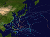
- 2014 Pacific typhoon season
- Pacific typhoon seasons
- Tropical cyclones in 2014