Assé-le-Riboul
Assé-le-Riboul | |
|---|---|
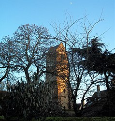 The bell tower of the church | |
show Location of Assé-le-Riboul | |
 Assé-le-Riboul | |
| Coordinates: 48°11′41″N 0°05′14″E / 48.1947°N 0.0873°ECoordinates: 48°11′41″N 0°05′14″E / 48.1947°N 0.0873°E | |
| Country | France |
| Region | Pays de la Loire |
| Department | Sarthe |
| Arrondissement | Mamers |
| Canton | Sillé-le-Guillaume |
| Intercommunality | |
| Government | |
| • Mayor (2014-2020) | Philippe Habert |
| Area 1 | 16.77 km2 (6.47 sq mi) |
| Population (Jan. 2018)[1] | 504 |
| • Density | 30/km2 (78/sq mi) |
| Demonym(s) | Asséen, Asséenne |
| Time zone | UTC+01:00 (CET) |
| • Summer (DST) | UTC+02:00 (CEST) |
| INSEE/Postal code | 72011 /72170 |
| Elevation | 57–138 m (187–453 ft) |
| 1 French Land Register data, which excludes lakes, ponds, glaciers > 1 km2 (0.386 sq mi or 247 acres) and river estuaries. | |


Assé-le-Riboul is a commune in the Sarthe department in the region of Pays de la Loire in north-western France.
See also[]
- Communes of the Sarthe department
References[]
- ^ "Populations légales 2018". INSEE. 28 December 2020.
| Wikimedia Commons has media related to Assé-le-Riboul. |
| show Communes of the Sarthe department |
|---|
This Sarthe geographical article is a stub. You can help Wikipedia by . |
Categories:
- Communes of Sarthe
- Sarthe geography stubs