Bartın
Bartın | |
|---|---|
Municipality | |
 Location of Bartın District in Bartın Province | |
 Bartın | |
| Coordinates: 41°38′04″N 32°20′15″E / 41.63444°N 32.33750°ECoordinates: 41°38′04″N 32°20′15″E / 41.63444°N 32.33750°E | |
| Country | Turkey |
| Province | Bartın |
| Government | |
| • Mayor | Cemal Akın (MHP) |
| Area | |
| • District | 1,027.76 km2 (396.82 sq mi) |
| Population (2012)[2] | |
| • Urban | 56,557 |
| • District | 143,262 |
| • District density | 140/km2 (360/sq mi) |
| Climate | Cfb |
| Website | www.bartin.bel.tr |

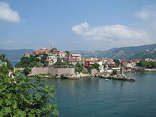
Bartın is a city in northern Turkey and the central district of the province of Bartın.
Formerly a district of Zonguldak Province, Bartın was made into a province seat in 1991 with the constitution of its province, including four districts: Central Bartın, Amasra, Kurucaşile, and Ulus). The city, with a population of c. 48,000,[3] is situated 14 kilometres (8.7 mi) inland on the Bartın River (Bartın Çayı) that is navigable for vessels between the city and the Black Sea coast. Bartın River is the only navigable river for vessels in Turkey.
History[]
The history of the antique Parthenios city (Παρθένιος in Greek), or Parthenia,[4] dates back to 1200 BC, when its area was inhabited by the Kaskian tribe. In the following centuries, the region had entered under the dominance of Hittites, Phrygians, Cimmerians, Lydians, Greeks, Persians and Macedonians. Later, it was part of the Roman Empire and then of the Byzantine Empire, until it fell to the Seljuk Turks and the Candaroğulları State between the 11th and the 13th centuries AD. Bartın was conquered by the Ottoman sultan Bayezid I in 1392.[5][6] In the late 19th and early 20th century, Bartın was part of the Kastamonu Vilayet of the Ottoman Empire.
Main sights[]
Bartın is a member of the Norwich-based European Association of Historic Towns and Regions (EAHTR).[7]
Main sights include the castle, two churches, bedesten, the Kuşkayası Road Monument and İnziva (seclusion) Cave in the city center. Sections of the ancient city like the forum, the council palace, the road of honor, the theatre, the acropolis, and a necropolis are now below the ground.
The wooden Bartın houses display the architectural characteristics of the art movements after the Tanzimat Fermanı (Reforms Decree).
Climate[]
Bartın has an humid subtropical (Cfa) climate under the Köppen classification, or an oceanic climate (Do) under the Trewartha classification. Summers are very warm, the average temperature is around 23 °C in July and August. Winters are cool and damp, and the average temperature is around 4 °C in January and February.
Precipitation is heaviest in autumn and early winter and lightest in spring. Snowfall is somewhat common between the months of December and March, snowing for a week or two, and it can be heavy once it snows.
| hideClimate data for Bartın (1991–2020, extremes 1961–2020) | |||||||||||||
|---|---|---|---|---|---|---|---|---|---|---|---|---|---|
| Month | Jan | Feb | Mar | Apr | May | Jun | Jul | Aug | Sep | Oct | Nov | Dec | Year |
| Record high °C (°F) | 23.2 (73.8) |
27.2 (81.0) |
31.6 (88.9) |
34.1 (93.4) |
39.1 (102.4) |
38.0 (100.4) |
42.8 (109.0) |
41.3 (106.3) |
40.5 (104.9) |
37.1 (98.8) |
29.0 (84.2) |
27.7 (81.9) |
42.8 (109.0) |
| Average high °C (°F) | 9.3 (48.7) |
10.8 (51.4) |
13.6 (56.5) |
18.1 (64.6) |
22.5 (72.5) |
26.4 (79.5) |
28.8 (83.8) |
29.2 (84.6) |
25.6 (78.1) |
21.1 (70.0) |
16.1 (61.0) |
11.3 (52.3) |
19.4 (66.9) |
| Daily mean °C (°F) | 4.1 (39.4) |
4.9 (40.8) |
7.4 (45.3) |
11.4 (52.5) |
15.9 (60.6) |
20.2 (68.4) |
22.6 (72.7) |
22.6 (72.7) |
18.5 (65.3) |
14.4 (57.9) |
9.1 (48.4) |
5.7 (42.3) |
13.1 (55.6) |
| Average low °C (°F) | 0.5 (32.9) |
0.7 (33.3) |
2.6 (36.7) |
5.8 (42.4) |
10.2 (50.4) |
14.1 (57.4) |
16.3 (61.3) |
16.4 (61.5) |
12.8 (55.0) |
9.5 (49.1) |
4.5 (40.1) |
1.9 (35.4) |
7.9 (46.2) |
| Record low °C (°F) | −15.4 (4.3) |
−18.6 (−1.5) |
−13.1 (8.4) |
−4.5 (23.9) |
−1.3 (29.7) |
5.3 (41.5) |
8.0 (46.4) |
6.7 (44.1) |
1.5 (34.7) |
−3.2 (26.2) |
−5.6 (21.9) |
−10.6 (12.9) |
−18.6 (−1.5) |
| Average precipitation mm (inches) | 112.8 (4.44) |
87.1 (3.43) |
82.9 (3.26) |
54.1 (2.13) |
55.5 (2.19) |
82.4 (3.24) |
60.6 (2.39) |
78.7 (3.10) |
99.7 (3.93) |
123.9 (4.88) |
108.9 (4.29) |
125.8 (4.95) |
1,072.4 (42.22) |
| Average precipitation days | 17.53 | 15.30 | 15.23 | 12.93 | 11.57 | 9.77 | 6.93 | 6.50 | 10.53 | 12.57 | 13.30 | 17.77 | 149.9 |
| Mean monthly sunshine hours | 68.2 | 93.2 | 130.2 | 180.0 | 229.4 | 267.0 | 306.9 | 291.4 | 222.0 | 161.2 | 114.0 | 74.4 | 2,137.9 |
| Mean daily sunshine hours | 2.2 | 3.3 | 4.2 | 6.0 | 7.4 | 8.9 | 9.9 | 9.4 | 7.4 | 5.2 | 3.8 | 2.4 | 5.8 |
| Source: Turkish State Meteorological Service[8] | |||||||||||||
Culture[]
The city hosts strawberry festivals in spring. The city also has beaches of good quality.
Notes[]
- ^ "Area of regions (including lakes), km²". Regional Statistics Database. Turkish Statistical Institute. 2002. Retrieved 2013-03-05.
- ^ "Population of province/district centers and towns/villages by districts - 2012". Address Based Population Registration System (ABPRS) Database. Turkish Statistical Institute. Retrieved 2013-02-27.
- ^ tuikapp.tuik.gov.tr Archived 2015-09-20 at the Wayback Machine
- ^ Richard Talbert, ed. (2000). Barrington Atlas of the Greek and Roman World. Princeton University Press. p. 86, and directory notes accompanying.
- ^ Bartın Archived May 11, 2012, at the Wayback Machine
- ^ [1] Bartın history(tr)
- ^ See historic-towns.org Archived 2008-09-10 at the Wayback Machine.
- ^ "Resmi İstatistikler: İllerimize Ait Mevism Normalleri (1991–2020)" (in Turkish). Turkish State Meteorological Service. Retrieved 24 April 2021.
External links[]
- English Information of Bartın
- Bartın Şehir ve Firma Rehberi Archived 2021-01-22 at the Wayback Machine
- Chisholm, Hugh, ed. (1911). . Encyclopædia Britannica. 3 (11th ed.). Cambridge University Press.
| show Bartın in Bartın Province of Turkey |
|---|

| show |
|---|
| show Authority control |
|---|
- Bartın
- Districts of Bartın Province
- Populated places in Bartın Province
- Black Sea port cities and towns in Turkey
- Bartın Central District