Chamaloc
Chamaloc | |
|---|---|
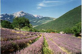 Fields of lavander at Chamaloc | |
show Location of Chamaloc | |
 Chamaloc | |
| Coordinates: 44°47′59″N 5°23′05″E / 44.7997°N 5.3847°ECoordinates: 44°47′59″N 5°23′05″E / 44.7997°N 5.3847°E | |
| Country | France |
| Region | Auvergne-Rhône-Alpes |
| Department | Drôme |
| Arrondissement | Die |
| Canton | Le Diois |
| Intercommunality | Diois |
| Government | |
| • Mayor (2020–2026) | Michel Vartanian[1] |
| Area 1 | 21.89 km2 (8.45 sq mi) |
| Population (Jan. 2018)[2] | 130 |
| • Density | 5.9/km2 (15/sq mi) |
| Time zone | UTC+01:00 (CET) |
| • Summer (DST) | UTC+02:00 (CEST) |
| INSEE/Postal code | 26069 /26150 |
| Elevation | 471–1,654 m (1,545–5,427 ft) |
| 1 French Land Register data, which excludes lakes, ponds, glaciers > 1 km2 (0.386 sq mi or 247 acres) and river estuaries. | |


Chamaloc is a commune of the Drôme department in southeastern France.
Population[]
| Year | Pop. | ±% |
|---|---|---|
| 1911 | 190 | — |
| 1962 | 89 | −53.2% |
| 1968 | 75 | −15.7% |
| 1975 | 52 | −30.7% |
| 1982 | 85 | +63.5% |
| 1990 | 93 | +9.4% |
| 1999 | 101 | +8.6% |
| 2008 | 115 | +13.9% |
See also[]
References[]
- ^ "Répertoire national des élus: les maires". data.gouv.fr, Plateforme ouverte des données publiques françaises (in French). 2 December 2020.
- ^ "Populations légales 2018". INSEE. 28 December 2020.
| Wikimedia Commons has media related to Chamaloc. |
This Drôme geographical article is a stub. You can help Wikipedia by . |
Categories:
- Communes of Drôme
- Drôme geography stubs