Vercheny
Vercheny | |
|---|---|
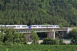 The Vercheny viaduct | |
show Location of Vercheny | |
 Vercheny | |
| Coordinates: 44°42′40″N 5°15′00″E / 44.711°N 5.250°ECoordinates: 44°42′40″N 5°15′00″E / 44.711°N 5.250°E | |
| Country | France |
| Region | Auvergne-Rhône-Alpes |
| Department | Drôme |
| Arrondissement | Die |
| Canton | Le Diois |
| Government | |
| • Mayor (2020–2026) | Franck Monge[1] |
| Area 1 | 11.19 km2 (4.32 sq mi) |
| Population (Jan. 2018)[2] | 466 |
| • Density | 42/km2 (110/sq mi) |
| Time zone | UTC+01:00 (CET) |
| • Summer (DST) | UTC+02:00 (CEST) |
| INSEE/Postal code | 26368 /26340 |
| Elevation | 280–1,109 m (919–3,638 ft) (avg. 306 m or 1,004 ft) |
| 1 French Land Register data, which excludes lakes, ponds, glaciers > 1 km2 (0.386 sq mi or 247 acres) and river estuaries. | |


Vercheny is a commune in the Drôme department in southeastern France.
Population[]
| Year | Pop. | ±% |
|---|---|---|
| 1911 | 345 | — |
| 1962 | 253 | −26.7% |
| 1968 | 268 | +5.9% |
| 1975 | 415 | +54.9% |
| 1982 | 421 | +1.4% |
| 1990 | 427 | +1.4% |
| 1999 | 387 | −9.4% |
| 2008 | 437 | +12.9% |
See also[]
References[]
- ^ "Répertoire national des élus: les maires". data.gouv.fr, Plateforme ouverte des données publiques françaises (in French). 2 December 2020.
- ^ "Populations légales 2018". INSEE. 28 December 2020.
| Wikimedia Commons has media related to Vercheny. |
This Drôme geographical article is a stub. You can help Wikipedia by . |
Categories:
- Communes of Drôme
- Drôme geography stubs