Rémuzat
Rémuzat | |
|---|---|
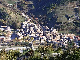 A view of Rémuzat from the nearby hillside | |
 Coat of arms | |
show Location of Rémuzat | |
 Rémuzat | |
| Coordinates: 44°24′51″N 5°21′25″E / 44.4142°N 5.3569°ECoordinates: 44°24′51″N 5°21′25″E / 44.4142°N 5.3569°E | |
| Country | France |
| Region | Auvergne-Rhône-Alpes |
| Department | Drôme |
| Arrondissement | Nyons |
| Canton | Nyons et Baronnies |
| Government | |
| • Mayor (2020–2026) | Olivier Salin |
| Area 1 | 16.78 km2 (6.48 sq mi) |
| Population (Jan. 2018)[1] | 334 |
| • Density | 20/km2 (52/sq mi) |
| Time zone | UTC+01:00 (CET) |
| • Summer (DST) | UTC+02:00 (CEST) |
| INSEE/Postal code | 26264 /26510 |
| Elevation | 425–1,201 m (1,394–3,940 ft) |
| 1 French Land Register data, which excludes lakes, ponds, glaciers > 1 km2 (0.386 sq mi or 247 acres) and river estuaries. | |


Rémuzat (French pronunciation: [ʁemyza]; Vivaro-Alpine: Remusat) is a commune in the Drôme department in southeastern France.
Population[]
| Year | Pop. | ±% |
|---|---|---|
| 1911 | 517 | — |
| 1962 | 288 | −44.3% |
| 1968 | 301 | +4.5% |
| 1975 | 332 | +10.3% |
| 1982 | 364 | +9.6% |
| 1990 | 364 | +0.0% |
| 1999 | 283 | −22.3% |
| 2008 | 317 | +12.0% |
Sights[]
- The Rocher du Caire, a large cliff inhabited by griffon vultures.
See also[]
References[]
- ^ "Populations légales 2018". INSEE. 28 December 2020.
| Wikimedia Commons has media related to Rémuzat. |
| show Authority control |
|---|
This Drôme geographical article is a stub. You can help Wikipedia by . |
Categories:
- Communes of Drôme
- Drôme geography stubs