Montferrand-la-Fare
Montferrand-la-Fare | |
|---|---|
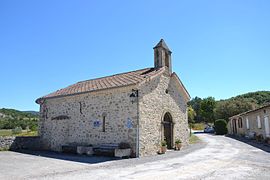 The church in Montferrand-la-Fare | |
show Location of Montferrand-la-Fare | |
 Montferrand-la-Fare | |
| Coordinates: 44°21′39″N 5°27′01″E / 44.3608°N 5.4503°ECoordinates: 44°21′39″N 5°27′01″E / 44.3608°N 5.4503°E | |
| Country | France |
| Region | Auvergne-Rhône-Alpes |
| Department | Drôme |
| Arrondissement | Nyons |
| Canton | Nyons et Baronnies |
| Government | |
| • Mayor (2020–2026) | Sylvie Garnero |
| Area 1 | 11.24 km2 (4.34 sq mi) |
| Population (Jan. 2018)[1] | 29 |
| • Density | 2.6/km2 (6.7/sq mi) |
| Time zone | UTC+01:00 (CET) |
| • Summer (DST) | UTC+02:00 (CEST) |
| INSEE/Postal code | 26199 /26510 |
| Elevation | 546–1,392 m (1,791–4,567 ft) |
| 1 French Land Register data, which excludes lakes, ponds, glaciers > 1 km2 (0.386 sq mi or 247 acres) and river estuaries. | |


Montferrand-la-Fare (French pronunciation: [mɔ̃fɛʁɑ̃ la faʁ]; Occitan: Montferrand e La Fara) is a commune in the Drôme department in southeastern France.
Population[]
| Year | Pop. | ±% |
|---|---|---|
| 1911 | 96 | — |
| 1962 | 41 | −57.3% |
| 1968 | 43 | +4.9% |
| 1975 | 46 | +7.0% |
| 1982 | 35 | −23.9% |
| 1990 | 32 | −8.6% |
| 1999 | 46 | +43.8% |
| 2008 | 54 | +17.4% |
See also[]
References[]
- ^ "Populations légales 2018". INSEE. 28 December 2020.
| Wikimedia Commons has media related to Montferrand-la-Fare. |
This Drôme geographical article is a stub. You can help Wikipedia by . |
Categories:
- Communes of Drôme
- Drôme geography stubs