Montchenu
Montchenu | |
|---|---|
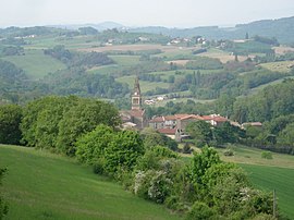 A general view of Montchenu | |
show Location of Montchenu | |
 Montchenu | |
| Coordinates: 45°11′47″N 5°01′57″E / 45.1964°N 5.0325°ECoordinates: 45°11′47″N 5°01′57″E / 45.1964°N 5.0325°E | |
| Country | France |
| Region | Auvergne-Rhône-Alpes |
| Department | Drôme |
| Arrondissement | Valence |
| Canton | Drôme des collines |
| Government | |
| • Mayor (2020–2026) | Roger Vossier[1] |
| Area 1 | 16.15 km2 (6.24 sq mi) |
| Population (Jan. 2018)[2] | 582 |
| • Density | 36/km2 (93/sq mi) |
| Time zone | UTC+01:00 (CET) |
| • Summer (DST) | UTC+02:00 (CEST) |
| INSEE/Postal code | 26194 /26350 |
| Elevation | 263–489 m (863–1,604 ft) (avg. 175 m or 574 ft) |
| 1 French Land Register data, which excludes lakes, ponds, glaciers > 1 km2 (0.386 sq mi or 247 acres) and river estuaries. | |


Montchenu (French pronunciation: [mɔ̃ʃəny]) is a commune in the Drôme department in southeastern France.
Population[]
| Year | Pop. | ±% |
|---|---|---|
| 1911 | 804 | — |
| 1962 | 399 | −50.4% |
| 1968 | 455 | +14.0% |
| 1975 | 386 | −15.2% |
| 1982 | 381 | −1.3% |
| 1990 | 389 | +2.1% |
| 1999 | 456 | +17.2% |
| 2008 | 564 | +23.7% |
See also[]
References[]
- ^ "Répertoire national des élus: les maires". data.gouv.fr, Plateforme ouverte des données publiques françaises (in French). 2 December 2020.
- ^ "Populations légales 2018". INSEE. 28 December 2020.
| Wikimedia Commons has media related to Montchenu. |
This Drôme geographical article is a stub. You can help Wikipedia by . |
Categories:
- Communes of Drôme
- Drôme geography stubs