Chamborigaud
Chamborigaud | |
|---|---|
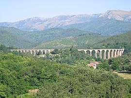 Viaduct of Chamborigaud, with Mont Lozère in the background | |
 Coat of arms | |
show Location of Chamborigaud | |
 Chamborigaud | |
| Coordinates: 44°18′07″N 3°58′43″E / 44.302°N 3.9786°ECoordinates: 44°18′07″N 3°58′43″E / 44.302°N 3.9786°E | |
| Country | France |
| Region | Occitanie |
| Department | Gard |
| Arrondissement | Alès |
| Canton | La Grand-Combe |
| Intercommunality | Alès Agglomération |
| Government | |
| • Mayor (2020–2026) | Émile Corbier[1] |
| Area 1 | 17.86 km2 (6.90 sq mi) |
| Population (Jan. 2018)[2] | 863 |
| • Density | 48/km2 (130/sq mi) |
| Time zone | UTC+01:00 (CET) |
| • Summer (DST) | UTC+02:00 (CEST) |
| INSEE/Postal code | 30080 /30530 |
| Elevation | 259–887 m (850–2,910 ft) (avg. 329 m or 1,079 ft) |
| 1 French Land Register data, which excludes lakes, ponds, glaciers > 1 km2 (0.386 sq mi or 247 acres) and river estuaries. | |


Chamborigaud is a commune in the Gard department in southern France.
The village is known for its stunning viaduct, designed by Charles Dombre, the construction of which ended in 1867. Unlike most other bridges of this type, the curve of the Viaduct of Chamborigaud faces upstream.
Population[]
| Year | Pop. | ±% |
|---|---|---|
| 1793 | 695 | — |
| 1821 | 923 | +32.8% |
| 1846 | 844 | −8.6% |
| 1872 | 1,363 | +61.5% |
| 1901 | 1,455 | +6.7% |
| 1926 | 1,513 | +4.0% |
| 1946 | 1,281 | −15.3% |
| 1962 | 1,313 | +2.5% |
| 1968 | 1,083 | −17.5% |
| 1975 | 869 | −19.8% |
| 1982 | 872 | +0.3% |
| 1990 | 716 | −17.9% |
| 1999 | 731 | +2.1% |
| 2008 | 782 | +7.0% |
See also[]
- Communes of the Gard department
References[]
- ^ "Répertoire national des élus: les maires". data.gouv.fr, Plateforme ouverte des données publiques françaises (in French). 2 December 2020.
- ^ "Populations légales 2018". INSEE. 28 December 2020.
External links[]
| Wikimedia Commons has media related to Chamborigaud. |
| show Communes of the Gard department |
|---|
This Gard geographical article is a stub. You can help Wikipedia by . |
Categories:
- Communes of Gard
- Gard geography stubs