Gaujac, Gard
Gaujac | |
|---|---|
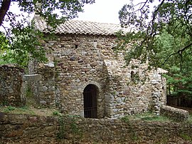 Saint-Saturnin chapel | |
 Coat of arms | |
show Location of Gaujac | |
 Gaujac | |
| Coordinates: 44°04′47″N 4°34′45″E / 44.0797°N 4.5792°ECoordinates: 44°04′47″N 4°34′45″E / 44.0797°N 4.5792°E | |
| Country | France |
| Region | Occitanie |
| Department | Gard |
| Arrondissement | Nîmes |
| Canton | Bagnols-sur-Cèze |
| Government | |
| • Mayor (2008–2014) | Daniel Viala |
| Area 1 | 10.28 km2 (3.97 sq mi) |
| Population (Jan. 2018)[1] | 1,087 |
| • Density | 110/km2 (270/sq mi) |
| Time zone | UTC+01:00 (CET) |
| • Summer (DST) | UTC+02:00 (CEST) |
| INSEE/Postal code | 30127 /30330 |
| Elevation | 85–264 m (279–866 ft) (avg. 144 m or 472 ft) |
| 1 French Land Register data, which excludes lakes, ponds, glaciers > 1 km2 (0.386 sq mi or 247 acres) and river estuaries. | |


Gaujac is a commune in the Gard department in southern France.
Population[]
| Year | Pop. | ±% |
|---|---|---|
| 1962 | 278 | — |
| 1968 | 280 | +0.7% |
| 1975 | 278 | −0.7% |
| 1982 | 433 | +55.8% |
| 1990 | 596 | +37.6% |
| 1999 | 643 | +7.9% |
| 2008 | 939 | +46.0% |
See also[]
- Communes of the Gard department
References[]
- ^ "Populations légales 2018". INSEE. 28 December 2020.
| Wikimedia Commons has media related to Gaujac (Gard). |
| show Communes of the Gard department |
|---|
This Gard geographical article is a stub. You can help Wikipedia by . |
Categories:
- Communes of Gard
- Gard geography stubs