Saint-André-d'Olérargues
Saint-André-d'Olérargues | |
|---|---|
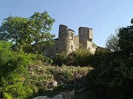 The chateau of Saint-André-d'Olérargues | |
 Coat of arms | |
show Location of Saint-André-d'Olérargues | |
 Saint-André-d'Olérargues | |
| Coordinates: 44°09′46″N 4°29′10″E / 44.1628°N 4.4861°ECoordinates: 44°09′46″N 4°29′10″E / 44.1628°N 4.4861°E | |
| Country | France |
| Region | Occitanie |
| Department | Gard |
| Arrondissement | Nîmes |
| Canton | Pont-Saint-Esprit |
| Government | |
| • Mayor (2014–2020) | Florent Gandi |
| Area 1 | 9.75 km2 (3.76 sq mi) |
| Population (Jan. 2018)[1] | 428 |
| • Density | 44/km2 (110/sq mi) |
| Time zone | UTC+01:00 (CET) |
| • Summer (DST) | UTC+02:00 (CEST) |
| INSEE/Postal code | 30232 /30330 |
| Elevation | 86–263 m (282–863 ft) (avg. 217 m or 712 ft) |
| 1 French Land Register data, which excludes lakes, ponds, glaciers > 1 km2 (0.386 sq mi or 247 acres) and river estuaries. | |


Saint-André-d'Olérargues is a commune in the Gard department in southern France.
Population[]
| Year | Pop. | ±% |
|---|---|---|
| 1962 | 144 | — |
| 1968 | 153 | +6.2% |
| 1975 | 145 | −5.2% |
| 1982 | 192 | +32.4% |
| 1990 | 268 | +39.6% |
| 1999 | 289 | +7.8% |
| 2006 | 393 | +36.0% |
| 2011 | 406 | +3.3% |
See also[]
- Communes of the Gard department
References[]
- ^ "Populations légales 2018". INSEE. 28 December 2020.
| Wikimedia Commons has media related to Saint-André-d'Olérargues. |
| show Communes of the Gard department |
|---|
| show Authority control |
|---|
This Gard geographical article is a stub. You can help Wikipedia by . |
Categories:
- Communes of Gard
- Gard geography stubs