Creveney
Creveney | |
|---|---|
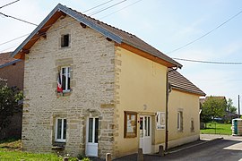 The town hall in Creveney | |
 Coat of arms | |
show Location of Creveney | |
 Creveney | |
| Coordinates: 47°41′05″N 6°17′33″E / 47.6847°N 6.2925°ECoordinates: 47°41′05″N 6°17′33″E / 47.6847°N 6.2925°E | |
| Country | France |
| Region | Bourgogne-Franche-Comté |
| Department | Haute-Saône |
| Arrondissement | Lure |
| Canton | Lure-1 |
| Area 1 | 2.44 km2 (0.94 sq mi) |
| Population (Jan. 2018)[1] | 55 |
| • Density | 23/km2 (58/sq mi) |
| Time zone | UTC+01:00 (CET) |
| • Summer (DST) | UTC+02:00 (CEST) |
| INSEE/Postal code | 70188 /70240 |
| Elevation | 249–331 m (817–1,086 ft) |
| 1 French Land Register data, which excludes lakes, ponds, glaciers > 1 km2 (0.386 sq mi or 247 acres) and river estuaries. | |


Creveney is a commune in the Haute-Saône department in the region of Bourgogne-Franche-Comté in eastern France.
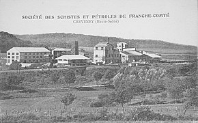
Creveney bituminous shale distillation plant, a rare operation in France between the two world wars
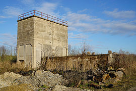
The ruins in 2015.


See also[]
References[]
- ^ "Populations légales 2018". INSEE. 28 December 2020.
| Wikimedia Commons has media related to Creveney. |
This Haute-Saône geographical article is a stub. You can help Wikipedia by . |
Categories:
- Communes of Haute-Saône
- Haute-Saône geography stubs