Fontaine-Française
From Wikipedia, the free encyclopedia
show This article may be expanded with text translated from the corresponding article in French. (January 2009) Click [show] for important translation instructions.
|
Commune in Bourgogne-Franche-Comté, France
Fontaine-Française | |
|---|---|
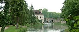 A general view of Fontaine-Française | |
 Coat of arms | |
 Fontaine-Française  Fontaine-Française | |
Coordinates:  47°31′34″N 5°22′14″E / 47.5261°N 5.3706°E / 47.5261; 5.3706Coordinates: 47°31′34″N 5°22′14″E / 47.5261°N 5.3706°E / 47.5261; 5.3706 47°31′34″N 5°22′14″E / 47.5261°N 5.3706°E / 47.5261; 5.3706Coordinates: 47°31′34″N 5°22′14″E / 47.5261°N 5.3706°E / 47.5261; 5.3706 | |
| Country | France |
| Region | Bourgogne-Franche-Comté |
| Department | Côte-d'Or |
| Arrondissement | Dijon |
| Canton | Saint-Apollinaire |
| Government | |
| • Mayor (2020–2026) | Nicolas Urbano[1] |
| Area 1 | 30.66 km2 (11.84 sq mi) |
| Population (Jan. 2018)[2] | 890 |
| • Density | 29/km2 (75/sq mi) |
| Time zone | UTC+01:00 (CET) |
| • Summer (DST) | UTC+02:00 (CEST) |
| INSEE/Postal code | 21277 /21610 |
| Elevation | 215–287 m (705–942 ft) (avg. 230 m or 750 ft) |
| 1 French Land Register data, which excludes lakes, ponds, glaciers > 1 km2 (0.386 sq mi or 247 acres) and river estuaries. | |

Fontaine-Française is a commune in the Côte-d'Or department in eastern France.
Population[]
| Year | Pop. | ±% |
|---|---|---|
| 1962 | 585 | — |
| 1968 | 658 | +12.5% |
| 1975 | 816 | +24.0% |
| 1982 | 857 | +5.0% |
| 1990 | 798 | −6.9% |
| 1999 | 916 | +14.8% |
| 2008 | 944 | +3.1% |
See also[]
References[]
- ^ "Répertoire national des élus: les maires". data.gouv.fr, Plateforme ouverte des données publiques françaises (in French). 2 December 2020.
- ^ "Populations légales 2018". INSEE. 28 December 2020.
| Wikimedia Commons has media related to Fontaine-Française. |
| show | |
|---|---|
|
| show Authority control | |
|---|---|
| General | |
| National libraries | |
Retrieved from ""
Categories:
- Communes of Côte-d'Or
- Côte-d'Or geography stubs
Hidden categories:
- CS1 French-language sources (fr)
- Articles to be expanded from January 2009
- All articles to be expanded
- Geography articles needing translation from French Wikipedia
- Articles with short description
- Short description is different from Wikidata
- Infobox mapframe without OSM relation ID on Wikidata
- Coordinates on Wikidata
- Pages using infobox settlement with image map1 but not image map
- Commons category link from Wikidata
- Articles with GND identifiers
- Articles with VIAF identifiers
- Articles with BNF identifiers
- Articles with WorldCat-VIAF identifiers
- Côte-d'Or communes articles needing translation from French Wikipedia
- All stub articles
- Pages using the Kartographer extension