Tart, Côte-d'Or
From Wikipedia, the free encyclopedia
Commune in Bourgogne-Franche-Comté, France
Tart | |
|---|---|
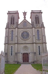 The church in Tart-le-Haut | |
Location of Tart  | |
 Tart  Tart | |
Coordinates:  47°12′18″N 5°12′24″E / 47.205°N 5.2067°E / 47.205; 5.2067Coordinates: 47°12′18″N 5°12′24″E / 47.205°N 5.2067°E / 47.205; 5.2067 47°12′18″N 5°12′24″E / 47.205°N 5.2067°E / 47.205; 5.2067Coordinates: 47°12′18″N 5°12′24″E / 47.205°N 5.2067°E / 47.205; 5.2067 | |
| Country | France |
| Region | Bourgogne-Franche-Comté |
| Department | Côte-d'Or |
| Arrondissement | Dijon |
| Canton | Genlis |
| Intercommunality | Plaine Dijonnaise |
| Area 1 | 13.68 km2 (5.28 sq mi) |
| Population (Jan. 2018)[1] | 1,579 |
| • Density | 120/km2 (300/sq mi) |
| Time zone | UTC+01:00 (CET) |
| • Summer (DST) | UTC+02:00 (CEST) |
| INSEE/Postal code | 21623 /21110 |
| Elevation | 187–238 m (614–781 ft) |
| 1 French Land Register data, which excludes lakes, ponds, glaciers > 1 km2 (0.386 sq mi or 247 acres) and river estuaries. | |
Tart is a commune in the Côte-d'Or department in eastern France. It was established on 1 January 2019 by merger of the former communes of Tart-le-Haut (the seat) and Tart-l'Abbaye.[2]
See also[]
References[]
- ^ "Populations légales 2018". The National Institute of Statistics and Economic Studies. 28 December 2020.
- ^ Arrêté préfectoral 26 December 2018 (in French)
| Wikimedia Commons has media related to Tart. |
|
Retrieved from ""
Categories:
- Communes of Côte-d'Or
- Populated places established in 2019
- 2019 establishments in France
- Côte-d'Or geography stubs
Hidden categories:
- Articles with French-language sources (fr)
- Articles with short description
- Short description is different from Wikidata
- Coordinates on Wikidata
- Pages using infobox settlement with image map1 but not image map
- Commons category link from Wikidata
- AC with 0 elements
- All stub articles
- Pages using the Kartographer extension