Lucey, Côte-d'Or
From Wikipedia, the free encyclopedia
Commune in Bourgogne-Franche-Comté, France
Lucey | |
|---|---|
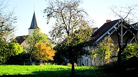 A general view of Lucey | |
 Coat of arms | |
 Lucey  Lucey | |
| Coordinates: 47°51′12″N 4°51′45″E / 47.8533°N 4.8625°E��� / 47.8533; 4.8625Coordinates: 47°51′12″N 4°51′45″E / 47.8533°N 4.8625°E / 47.8533; 4.8625 | |
| Country | France |
| Region | Bourgogne-Franche-Comté |
| Department | Côte-d'Or |
| Arrondissement | Montbard |
| Canton | Châtillon-sur-Seine |
| Intercommunality | Pays Châtillonnais |
| Government | |
| • Mayor (2020–2026) | Alain Trexon |
| Area 1 | 18.68 km2 (7.21 sq mi) |
| Population (Jan. 2018)[1] | 59 |
| • Density | 3.2/km2 (8.2/sq mi) |
| Time zone | UTC+01:00 (CET) |
| • Summer (DST) | UTC+02:00 (CEST) |
| INSEE/Postal code | 21359 /21290 |
| Elevation | 293–417 m (961–1,368 ft) (avg. 372 m or 1,220 ft) |
| 1 French Land Register data, which excludes lakes, ponds, glaciers > 1 km2 (0.386 sq mi or 247 acres) and river estuaries. | |

Lucey (French pronunciation: [lysɛ]) is a commune in the Côte-d'Or department in eastern France.
Population[]
| Year | Pop. | ±% |
|---|---|---|
| 1962 | 65 | — |
| 1968 | 78 | +20.0% |
| 1975 | 80 | +2.6% |
| 1982 | 73 | −8.8% |
| 1990 | 55 | −24.7% |
| 1999 | 61 | +10.9% |
| 2008 | 58 | −4.9% |
See also[]
References[]
- ^ "Populations légales 2018". INSEE. 28 December 2020.
| Wikimedia Commons has media related to Lucey (Côte-d'Or). |
| show | |
|---|---|
|
| show Authority control | |
|---|---|
| General |
|
| National libraries | |
| Other | |
Retrieved from ""
Categories:
- Communes of Côte-d'Or
- Côte-d'Or geography stubs
Hidden categories:
- Articles with short description
- Short description is different from Wikidata
- Infobox mapframe without OSM relation ID on Wikidata
- Coordinates on Wikidata
- Pages using infobox settlement with image map1 but not image map
- Commons category link is on Wikidata
- Articles with VIAF identifiers
- Articles with BNF identifiers
- Articles with NARA identifiers
- Articles with WorldCat-VIAF identifiers
- All stub articles
- Pages using the Kartographer extension