Montagny-lès-Seurre
Montagny-lès-Seurre | |
|---|---|
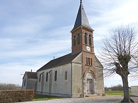 The church in Montagny-lès-Seurre | |
Location of Montagny-lès-Seurre  | |
 Montagny-lès-Seurre | |
| Coordinates: 47°01′27″N 5°15′16″E / 47.0242°N 5.2544°ECoordinates: 47°01′27″N 5°15′16″E / 47.0242°N 5.2544°E | |
| Country | France |
| Region | Bourgogne-Franche-Comté |
| Department | Côte-d'Or |
| Arrondissement | Beaune |
| Canton | Brazey-en-Plaine |
| Intercommunality | Rives de Saône |
| Government | |
| • Mayor (2020–2026) | Lucie Bonnin |
| Area 1 | 7.16 km2 (2.76 sq mi) |
| Population (Jan. 2018)[1] | 108 |
| • Density | 15/km2 (39/sq mi) |
| Time zone | UTC+01:00 (CET) |
| • Summer (DST) | UTC+02:00 (CEST) |
| INSEE/Postal code | 21424 /21250 |
| Elevation | 181–193 m (594–633 ft) (avg. 187 m or 614 ft) |
| 1 French Land Register data, which excludes lakes, ponds, glaciers > 1 km2 (0.386 sq mi or 247 acres) and river estuaries. | |


Montagny-lès-Seurre (French pronunciation: [mɔ̃taɲi lɛ sœʁ], literally Montagny near Seurre) is a commune in the Côte-d'Or department in eastern France.
Population[]
| Year | Pop. | ±% |
|---|---|---|
| 1962 | 109 | — |
| 1968 | 111 | +1.8% |
| 1975 | 112 | +0.9% |
| 1982 | 107 | −4.5% |
| 1990 | 119 | +11.2% |
| 1999 | 112 | −5.9% |
| 2008 | 107 | −4.5% |
See also[]
References[]
- ^ "Populations légales 2018". The National Institute of Statistics and Economic Studies. 28 December 2020.
Gallery[]

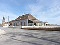
City Council

First World War Memorial
The old school

Rue de l'Église


| Wikimedia Commons has media related to Montagny-lès-Seurre. |
This Côte-d'Or geographical article is a stub. You can help Wikipedia by . |
Categories:
- Communes of Côte-d'Or
- Côte-d'Or geography stubs